

| Date: | Friday 26 July 2019 |
| Time: | 11:02 |
| Type: |  Cessna 208 Caravan 675 |
| Owner/operator: | Seair Seaplanes |
| Registration: | C-GURL |
| MSN: | 20800501 |
| Year of manufacture: | 2008 |
| Total airframe hrs: | 4576 hours |
| Engine model: | Pratt & Whitney Canada PT6A-114A |
| Fatalities: | Fatalities: 4 / Occupants: 9 |
| Aircraft damage: | Destroyed, written off |
| Category: | Accident |
| Location: | Addenbroke Island, BC -
 Canada Canada
|
| Phase: | En route |
| Nature: | Passenger - Non-Scheduled/charter/Air Taxi |
| Departure airport: | Vancouver International Water Airport, BC |
| Hakai Pass Seaplane Base, BC (YHC) | |
| Investigating agency: | TSB |
| Confidence Rating: |
Seair Seaplanes was contracted by a remote fishing lodge on the central coast of British Columbia, Canada to provide seasonal transport of guests and supplies between Vancouver International Water Airport (CAM9), BC, and the lodge, which is located about 66 nautical miles north-northwest of Port Hardy Airport (CYZT), BC.
On the morning of the occurrence, four Seair visual flight rules (VFR) flights were scheduled to fly to the central coast of BC, all on float-equipped Cessna Caravan aircraft. The first 3 flights were direct flights to the fishing lodge. Because of poor weather conditions in the central coast region, however, all of the flights were delayed.
After the crews referred to weather cameras along the central coast region, the flights began to depart, but in a different order than originally scheduled. One of Seairs senior operational staff (operations manager) departed CAM9 at 08:50 aboard C-FLAC. The occurrence aircraft departed at 09:32.
The pilot originally scheduled to fly C-GSAS declined the flight. This pilot had recently upgraded to the Caravan, had never flown to this destination before, and was concerned about the weather at the destination. When Seairs chief pilot returned to CAM9 at 09:53 after a series of scheduled flights on a different type of aircraft, he assumed the last remaining flight to the lodge and C-GSAS departed CAM9 at 10:24.
After departing the Vancouver terminal control area, the occurrence aircraft climbed to 4500 feet above sea level (ASL) and remained at this altitude until 10:23, when a slow descent was initiated. The aircraft levelled off at approximately 1300 feet ASL at 10:44, when it was approximately 18 NM northeast of Port Hardy Airport (CYZT), BC, and 57 NM southeast of the destination.
At 10:50, the occurrence aircraft slowly descended again as the flight continued northbound. During this descent, the aircrafts flaps were extended to the 10° position. At this point, the occurrence aircraft was 37 NM south-southeast of the fishing lodge. The aircraft continued to descend until it reached an altitude of approximately 330 feet ASL, at 10:56. By this point, the occurrence aircraft was being operated along the coastline, but over the ocean.
C-FLAC departed from the fishing lodge at 10:56 on the return flight to CAM9. C-FLAC flew into the Fitz Hugh Sound and proceeded southbound along the western shoreline. At approximately 11:00, it flew through an area of heavy rain where visibility was reduced to about 1 statute mile (SM). C-FLAC descended to about 170 feet ASL and maintained this altitude for the next 5 minutes before climbing to about 300 feet ASL.
As the southbound C-FLAC entered Fitz Hugh Sound from the north at Hecate Island, the occurrence aircraft entered Fitz Hugh Sound from the south, near the southern tip of Calvert Island. The occurrence aircraft then changed course from the western to the eastern shoreline, and descended again to about 230 feet ASL, while maintaining an airspeed of approximately 125 knots.
The two aircraft established 2-way radio contact. The pilot of C-FLAC indicated that Addenbroke Island was visible when he flew past it, and described the weather conditions in the Fitz Hugh Sound to the occurrence pilot as heavy rain showers and visibility of approximately 1 SM around Kelpie Point. The occurrence pilot then indicated that he would maintain a course along the eastern shoreline of the sound.
At 11:03, the two aircraft were separated by 2 NM and passed each other on reciprocal tracks, approximately 4 NM south of the accident site. The occurrence aircraft maintained a consistent track and altitude for the next 54 seconds, then slowly began a 25° change in track to the west (0.35 NM from the Addenbroke Island shoreline). Seven seconds after the turn started (0.12 NM from the islands shoreline), the aircraft entered a shallow climb averaging 665 fpm.
At 11:04:55, the occurrence aircraft struck trees on Addenbroke Island at an altitude of approximately 490 feet ASL, at an airspeed of 114 knots, and in a relatively straight and level attitude. The aircraft then continued through the heavily forested hillside for approximately 450 feet, coming to rest at an elevation of 425 feet ASL, 9.7 NM east-southeast of the destination fishing lodge.
The aircraft was destroyed by the impact forces and the pilot and three of the eight passengers were killed.
Findings as to causes and contributing factors:
1. The flight departed Vancouver International Water Aerodrome even though the reported and forecast weather conditions in the vicinity of the destination were below visual flight rules minima; the decision to depart may have been influenced by the group dynamics of Seair pilots and senior staff at the flight planning stage.
2. The pilot continued flight in reduced visibility, without recognizing the proximity to terrain, and subsequently impacted the rising terrain of Addenbroke Island.
3. The configuration of the visual and aural alerting systems and the colouration ambiguity in the primary flight display of the Garmin G1000 was ineffective at alerting the occurrence pilot to the rising terrain ahead.
4. The occurrence pilots attention, vigilance, and general cognitive function were most likely influenced to some degree by fatigue.
Accident investigation:
 |
|
Sources:
vancouverisland.ctvnews.ca
thestar.com
Location
Images:
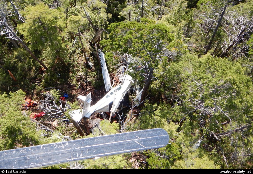
photo (c) TSB Canada; Addenbroke Island, BC; July 2019
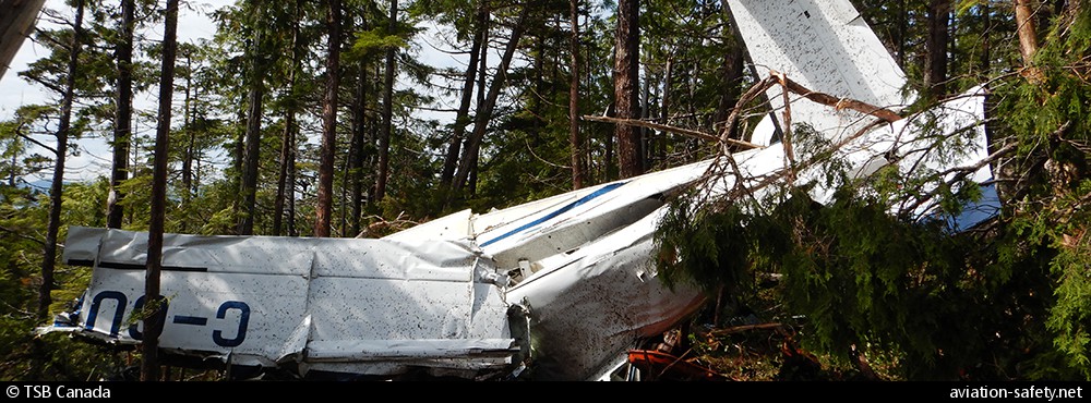
photo (c) TSB Canada; Addenbroke Island, BC; July 2019
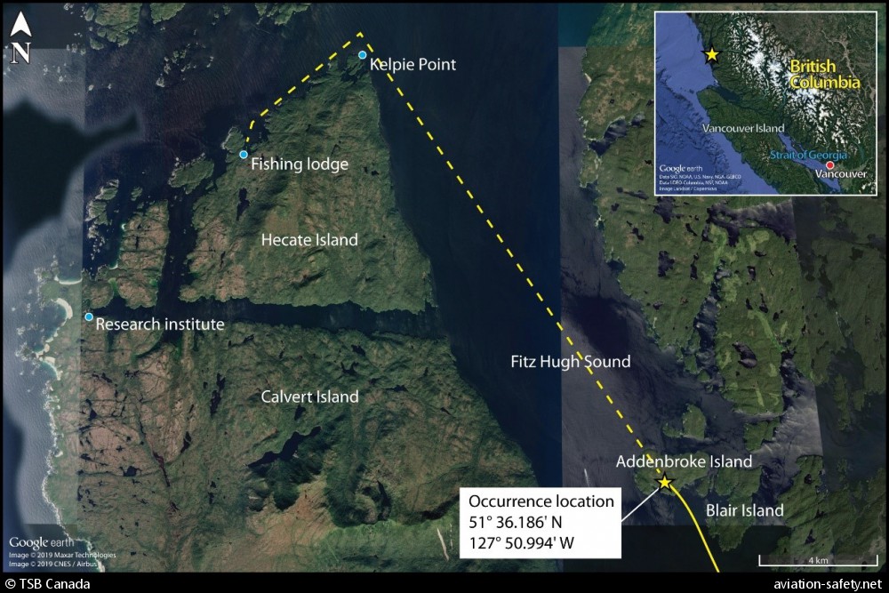
photo (c) TSB Canada; 27 July 2019; (CC:by-sa)
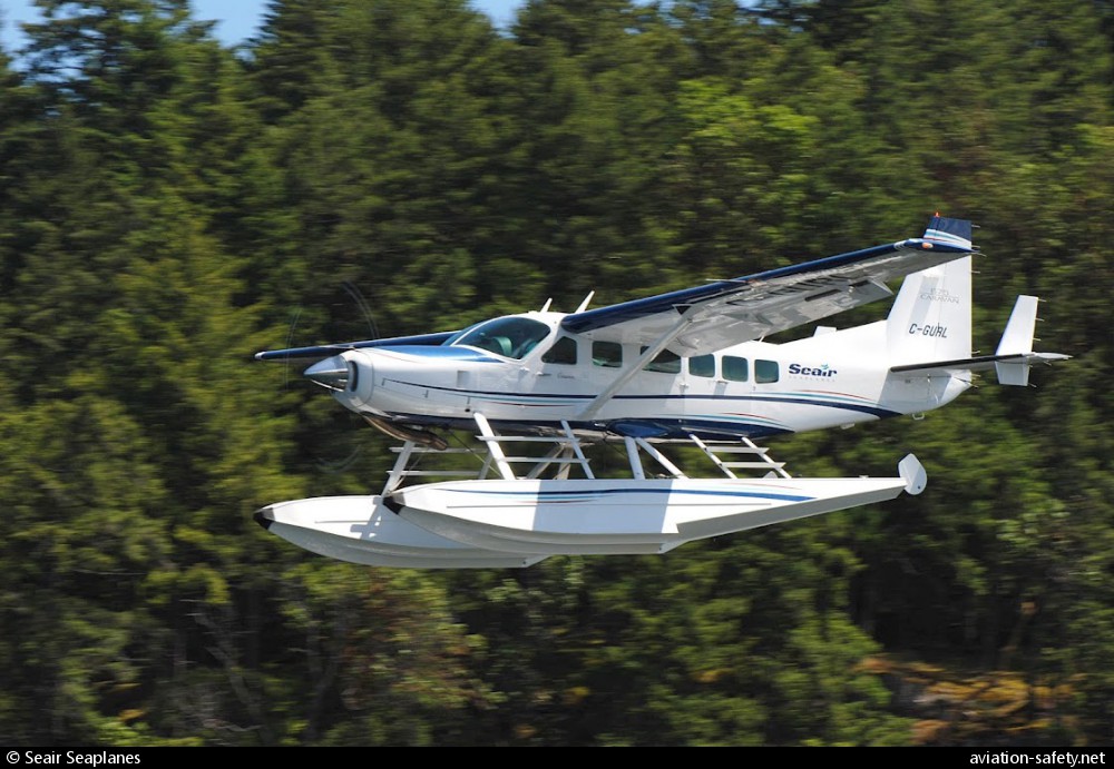
photo (c) Seair Seaplanes; February 2012; (CC:by-sa)
Revision history:
| Date/time | Contributor | Updates |
|---|
The Aviation Safety Network is an exclusive service provided by:
Quick Links:
| ASN Home | Send Correction / Feedback |
| FSF Home | Disclaimer | Copyright |
| Contact Us | Privacy Policy |
| Press / Media |
 ©2024 Flight Safety Foundation