

ASN Wikibase Occurrence # 163381
This information is added by users of ASN. Neither ASN nor the Flight Safety Foundation are responsible for the completeness or correctness of this information.
If you feel this information is incomplete or incorrect, you can submit corrected information.
| Date: | Sunday 19 January 2014 |
| Time: | 12:10 LT |
| Type: |  Piper PA-31-350 Navajo Chieftain |
| Owner/operator: | PT Intan Angkasa Air Service |
| Registration: | PK-IWT |
| MSN: | 31-7752090 |
| Year of manufacture: | 1977 |
| Fatalities: | Fatalities: 4 / Occupants: 4 |
| Aircraft damage: | Destroyed |
| Category: | Accident |
| Location: | 1.6 Nm NE of Langgur-Dumatubin Airport, Tual, Maluku -
 Indonesia Indonesia
|
| Phase: | Approach |
| Nature: | Ferry/positioning |
| Departure airport: | Sentani Airport, Jayapura, Papua (DJJ/WAJJ) |
| Dumatubin Airport, Tual, Maluku (WAPL) | |
| Investigating agency: | NTSC |
| Confidence Rating: |
On 19 January 2014, a Piper PA-31-350 Chieftain, registered PK-IWT, was being operated by PT. Intan Angkasa Air Service, on positioning flight from Sentani Airport, Jayapura with intended destination of Juanda Airport, Surabaya for aircraft maintenance. The positioning flight was planned to transit at Dumatubun Airport Langgur of Tual, Maluku and Haluoleo Airport, Kendari at South East Sulawesi for refuelling.
On the first sector, the aircraft departed Sentani Airport at 23:51 UTC (08:51 WIT) and estimated arrival at Langgur was 03:20 UTC. On board on this flight was one pilot, two company engineers and one ground staff.
At 02:40 UTC the pilot contacted to the Langgur FISO, reported that the aircraft position was 85 Nm to Langgur Airport at altitude 10,000 feet and requested weather information. Langgur FISO acknowledged and informed that the weather was rain and thunderstorm and the runway in use was 09.
When the aircraft was passing 5,000 feet, the pilot contacted the Langgur FISO and reported that the aircraft position was 50 Nm from Langgur and informed the estimated time of arrival was 03:20 UTC. The Langgur FISO acknowledged and advised the pilot to contact when the aircraft was at long final runway 09.
At 03:18 UTC, the pilot contacted Langgur FISO, reported the position was 25 Nm to Langgur at altitude of 2,500 feet and requested to use runway 27. The Langgur FISO advised the pilot to contact on final runway 27. Nothing more was heard from the flight.
The aircraft was found at approximately 1.6 Nm north east of Langgur Airport. All occupants fatally injured and the aircraft destroyed by impact force and post impact fire.
The aircraft was destroyed by impact forces and post impact fire, several parts of the remaining wreckage such as cockpit could not be examined due to the level of damage. The aircraft was not equipped with flight recorders and the communication between ATC and the pilot was not recorded. No eye witness saw the aircraft prior to impact. Information available for the investigation was limited. The analysis utilizes available information mainly on the wreckage information including the information of the wings, engines and propellers.
Based on the available evidences, the investigation concluded that the left engine failed during approach. The propeller did not set to feather resulted in significant asymmetric forces on the left and right side of the aircraft. The asymmetric forces created yaw and roll tendency and the aircraft became uncontrolled, subsequently led the aircraft to impact to the terrain.
Accident investigation:
 |
|
Sources:
NTSB
2. https://www.kaskus.co.id/thread/52db59ab5ccb17d0310002c5/another-tni-au-plane-crash-19-january-2014/
3. https://bali.antaranews.com/berita/47861/four-killed-in-plane-crash
4. http://www.thejakartapost.com/news/2014/01/19/victims-tual-plane-crash-identified.html
Images:
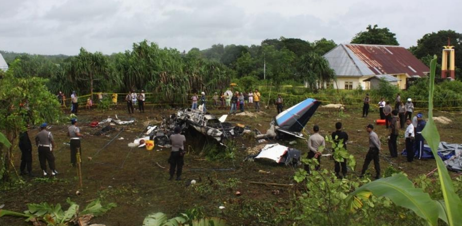
Photo: NTSC
Revision history:
| Date/time | Contributor | Updates |
|---|---|---|
| 19-Jan-2014 07:30 | gerard57 | Added |
| 19-Jan-2014 08:28 | gerard57 | Updated [Operator, Source] |
| 19-Jan-2014 08:30 | harro | Updated [Aircraft type, Cn] |
| 19-Jan-2014 20:32 | gerard57 | Updated [Source, Narrative] |
| 27-Jan-2014 07:44 | sigit jakarta | Updated [Nature, Narrative] |
| 20-Feb-2014 03:12 | Geno | Updated [Time, Operator, Location, Phase, Departure airport, Destination airport, Source, Narrative] |
| 02-Sep-2014 20:27 | Aerossurance | Updated [Source] |
| 22-Oct-2017 16:29 | Dr. John Smith | Updated [Source, Narrative] |
| 22-Oct-2017 16:36 | Dr. John Smith | Updated [Time, Location, Departure airport, Destination airport, Source, Narrative] |
| 22-Oct-2017 16:37 | Dr. John Smith | Updated [Source] |
| 19-Sep-2018 12:38 | harro | Updated [Location, Source, Narrative, Photo, Accident report, ] |
Corrections or additions? ... Edit this accident description
The Aviation Safety Network is an exclusive service provided by:
Quick Links:
| ASN Home | Send Correction / Feedback |
| FSF Home | Disclaimer | Copyright |
| Contact Us | Privacy Policy |
| Press / Media |
 ©2024 Flight Safety Foundation