

ASN Wikibase Occurrence # 175173
This information is added by users of ASN. Neither ASN nor the Flight Safety Foundation are responsible for the completeness or correctness of this information.
If you feel this information is incomplete or incorrect, you can submit corrected information.
| Date: | Tuesday 7 April 2015 |
| Time: | 00:06 |
| Type: |  Cessna 414A Chancellor |
| Owner/operator: | Make It Happen Aviation, LLC |
| Registration: | N789UP |
| MSN: | 414A0495 |
| Year of manufacture: | 1980 |
| Total airframe hrs: | 8390 hours |
| Engine model: | Continental TSIO-520-NB |
| Fatalities: | Fatalities: 7 / Occupants: 7 |
| Aircraft damage: | Destroyed |
| Category: | Accident |
| Location: | ENE of Central Illinois Regional Airport at Bloomington-Normal, IL -
 United States of America United States of America
|
| Phase: | Approach |
| Nature: | Private |
| Departure airport: | Indianapolis International Airport, IN (IND) |
| Central Illinois Regional Airport at Bloomington-Normal, IL (BMI) | |
| Investigating agency: | NTSB |
| Confidence Rating: |
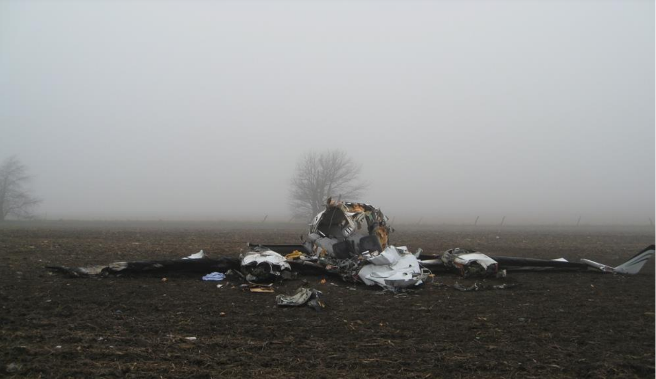
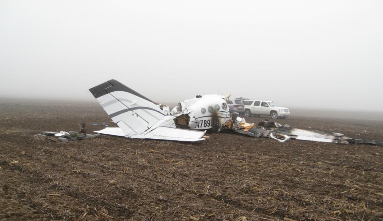
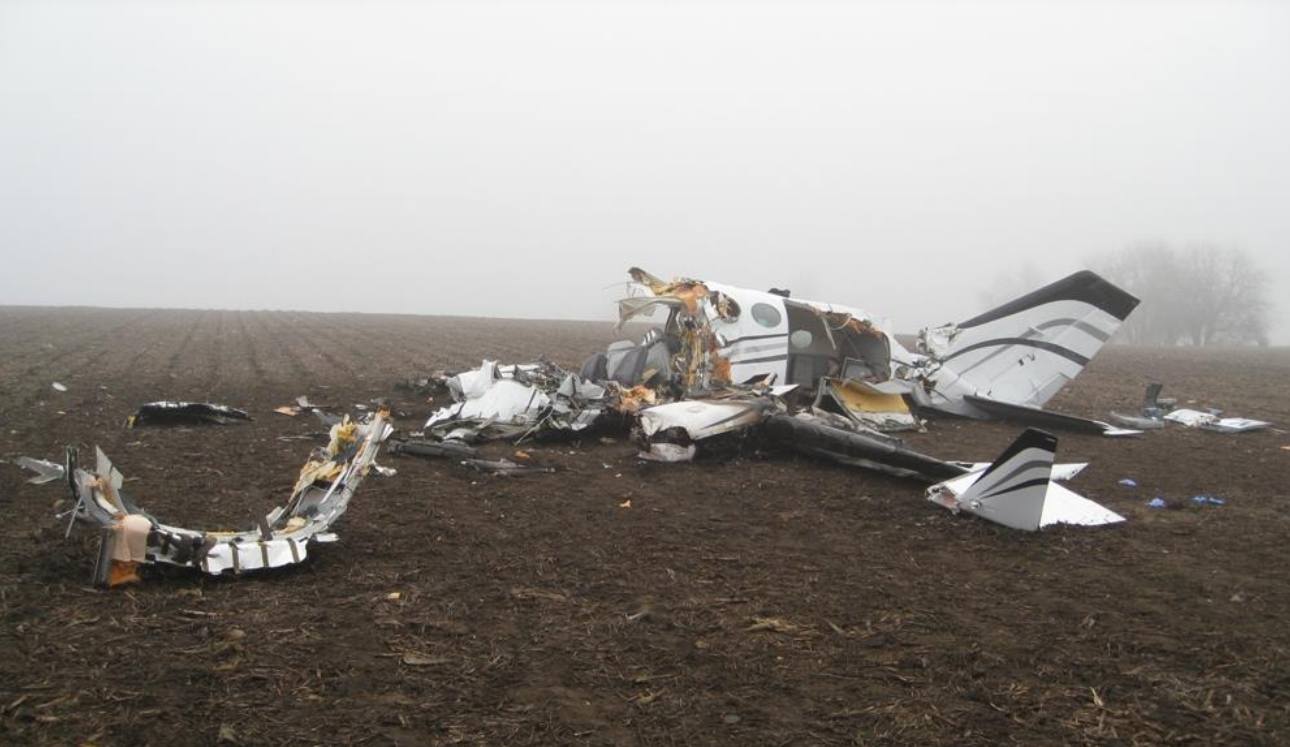
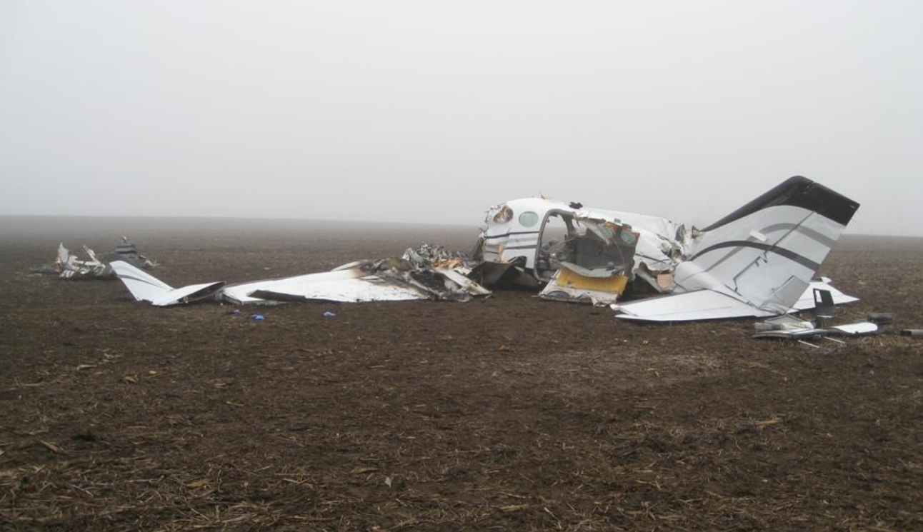
The twin-engine airplane, flown by an airline transport pilot, was approaching the destination airport after a cross-country flight in night instrument meteorological conditions. The destination airport weather conditions about 1 minute before the accident included an overcast ceiling at 200 ft and 1/2-mile visibility with light rain and fog. According to air traffic control (ATC) data, the flight received radar vectors to the final approach course for an instrument landing system (ILS) approach to runway 20. As shown by a postaccident simulation study based on radar data and data recovered from the airplane's electronic horizontal situation indicator (EHSI), the airplane's flight path did not properly intercept and track either the localizer or the glideslope during the instrument approach. The airplane crossed the final approach fix about 360 ft below the glideslope and then maintained a descent profile below the glideslope until it leveled briefly near the minimum descent altitude, likely for a localizer-only instrument approach. However, the lateral flight path from the final approach fix inbound was one or more dots to the right of the localizer centerline until the airplane was about 1 nautical mile from the runway 20 threshold when it turned 90° left to an east course. The turn was initiated before the airplane had reached the missed approach point; additionally, the left turn was not in accordance with the published missed approach instructions, which specified a climb on runway heading before making a right turn to a 270° magnetic heading. The airplane made a series of pitch excursions as it flew away from the localizer. The simulation study determined that dual engine power was required to match the recorded flight trajectory and ground speeds, which indicated that both engines were operating throughout the approach. The simulation results also indicated that, based on calculated angle of attack and lift coefficient data, the airplane likely encountered an aerodynamic stall during its course deviation to the east. The airplane impacted the ground about 2.2 miles east-northeast of the runway 20 threshold and about 1.75 miles east of the localizer centerline.
According to FAA documentation, at the time of the accident, all components of the airport's ILS were functional, with no recorded errors, and the localizer was radiating a front-course to the correct runway. Additionally, a postaccident flight check found no anomalies with the instrument approach.
An onsite examination established that the airplane impacted the ground upright and in a nose-low attitude, and the lack of an appreciable debris path was consistent with an aerodynamic stall/spin. Wreckage examinations did not reveal any anomalies with the airplane's flight control systems, engines, or propellers. The glideslope antenna was found disconnected from its associated cable circuit. Laboratory examination and testing determined that the glideslope antenna cable was likely inadequately connected/secured during the flight, which resulted in an unusable glideslope signal to the cockpit avionics. There was no history of recent maintenance on the glideslope antenna, and the reason for the inadequate connection could not be determined.
Data downloaded from the airplane's EHSI established that the device was in the ILS mode during the instrument approach phase and that it had achieved a valid localizer state on both navigation channels; however, the device never achieved a valid glideslope state on either channel during the flight. Further, a replay of the recorded EHSI data confirmed that, during the approach, the device displayed a large "X" through the glideslope scale and did not display a deviation pointer, both of which were indications of an invalid glideslope state.
There was no evidence of cumulative sleep loss, acute sleep loss, or medical conditions that indicated poor sleep quality for the pilot. However, the accident occurred more than 2 hours after the pilot routinely went to sleep, which suggests that the pilot's circadian system w
Probable Cause: The pilot's failure to maintain control of the airplane during the instrument approach in night instrument meteorological conditions, which resulted in the airplane exceeding its critical angle of attack and an aerodynamic stall/spin. Contributing to the accident were pilot fatigue, the pilot's increased workload during the instrument approach resulting from the lack of glideslope guidance due to an inadequately connected/secured glideslope antenna cable, and the airplane being loaded aft of its balance limit.
Accident investigation:
 |
|
Sources:
NTSB
https://flightaware.com/live/flight/N789UP
https://flightaware.com/live/flight/N789UP/history/20150407/0300Z/KIND/KBMI/tracklog
FAA register: http://registry.faa.gov/aircraftinquiry/NNum_Results.aspx?NNumbertxt=789UP
Location
Images:

Photos(c): NTSB
Media:
#OTD 2015 #Cessna 414 N789UP crashed on approach with 7 fatalities. Contributing were pilot fatigue, increased workload resulting from the lack of glideslope guidance due to a loose antenna cable and being loaded aft of balance limit.https://t.co/9EttTgiqlr #ntsb #flightsafety pic.twitter.com/3f3pBEA0dx
— Aerossurance (@Aerossurance) April 7, 2020
Revision history:
| Date/time | Contributor | Updates |
|---|---|---|
| 07-Apr-2015 12:25 | gerard57 | Added |
| 07-Apr-2015 12:26 | harro | Updated [Aircraft type, Location, Source] |
| 07-Apr-2015 12:32 | harro | Updated [Date, Time, Aircraft type, Registration, Cn, Departure airport, Destination airport, Source, Narrative] |
| 07-Apr-2015 12:36 | harro | Updated [Source, Narrative] |
| 07-Apr-2015 14:05 | harro | Updated [Registration, Source, Narrative] |
| 07-Apr-2015 15:36 | Geno | Updated [Aircraft type, Operator, Phase, Departure airport, Source, Narrative] |
| 07-Apr-2015 17:26 | gerard57 | Updated [Total fatalities, Total occupants, Source, Narrative] |
| 08-Apr-2015 05:45 | Aerossurance | Updated [Nature, Source, Narrative] |
| 16-Apr-2015 16:13 | Geno | Updated [Time, Location, Destination airport, Source, Damage] |
| 16-Apr-2015 16:14 | Anon. | Updated [Time, Location] |
| 21-Apr-2015 17:18 | Geno | Updated [Location, Nature, Source, Damage] |
| 21-Dec-2016 19:30 | ASN Update Bot | Updated [Time, Damage, Category, Investigating agency] |
| 30-Aug-2017 21:03 | Aerossurance | Updated [Time, Operator, Location, Destination airport, Narrative] |
| 06-Sep-2017 07:06 | ASN Update Bot | Updated [Time, Operator, Other fatalities, Departure airport, Destination airport, Source, Narrative] |
| 07-Apr-2020 08:40 | Aerossurance | Updated [Other fatalities, Source, Embed code, Damage, Narrative] |
| 06-Mar-2022 17:25 | Captain Adam | Updated [Location, Departure airport, Destination airport, Source, Embed code, Photo] |
| 06-Mar-2022 17:25 | Captain Adam | Updated [Photo] |
| 06-Mar-2022 17:25 | Captain Adam | Updated [Photo] |
| 06-Mar-2022 17:26 | Captain Adam | Updated [Category, Photo] |
| 06-Mar-2022 17:27 | Captain Adam | Updated [Photo] |
Corrections or additions? ... Edit this accident description
The Aviation Safety Network is an exclusive service provided by:
Quick Links:
| ASN Home | Send Correction / Feedback |
| FSF Home | Disclaimer | Copyright |
| Contact Us | Privacy Policy |
| Press / Media |
 ©2024 Flight Safety Foundation