

ASN Wikibase Occurrence # 177485
This information is added by users of ASN. Neither ASN nor the Flight Safety Foundation are responsible for the completeness or correctness of this information.
If you feel this information is incomplete or incorrect, you can submit corrected information.
| Date: | Wednesday 1 July 2015 |
| Time: | 10:00 |
| Type: |  Hughes 269C |
| Owner/operator: | Private |
| Registration: | N9490F |
| MSN: | 1030243 |
| Year of manufacture: | 1973 |
| Total airframe hrs: | 12733 hours |
| Engine model: | Lycoming HIO-360-D1A |
| Fatalities: | Fatalities: 2 / Occupants: 2 |
| Aircraft damage: | Destroyed |
| Category: | Accident |
| Location: | Ayres Gulch Canyon, near Asotin, WA -
 United States of America United States of America
|
| Phase: | Manoeuvring (airshow, firefighting, ag.ops.) |
| Nature: | Private |
| Departure airport: | Lewiston-Nez Perce County Regional Airport, ID (LWS/KLWS) |
| Lewiston-Nez Perce County Regional Airport, ID (LWS/KLWS) | |
| Investigating agency: | NTSB |
| Confidence Rating: |
On July 01, 2015, about 1000 Pacific daylight time, a Hughes 269C, N9490F, collided with powerlines while flying in a canyon in the vicinity of Asotin, Washington. Following the collision, the helicopter was consumed by fire and destroyed. The pilot was operating the helicopter under the provisions of 14 Code of Federal Regulations Part 91. The pilot and passenger were fatally injured. The personal local flight originated from the Lewiston-Nez Perce County Airport, Lewiston, Idaho about 0930. Visual meteorological conditions prevailed, and a flight plan had not been filed.
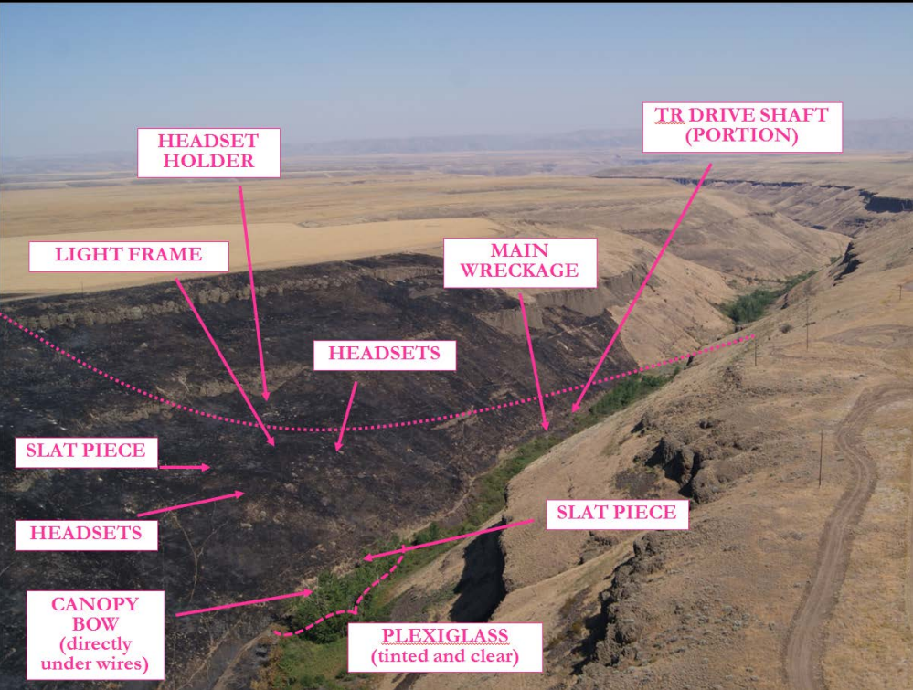
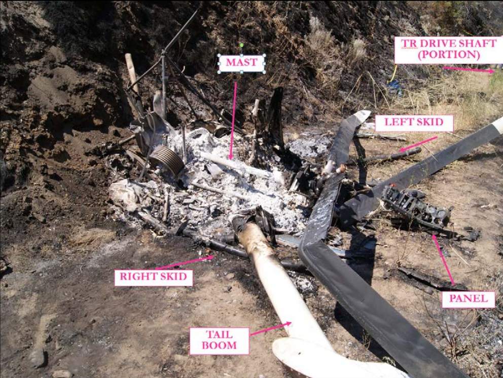
The private pilot and passenger were on a local area flight. While maneuvering in a canyon, the helicopter impacted power lines and descended to the canyon's wall. A fire ensued and burned the surrounding area. The power lines were located 350 ft south of the wreckage with two 35-ft support structures (wood poles) on either side of the canyon about 1,452 ft apart. The two 5/16-inch diameter power lines were oriented east-west and ran horizontally parallel to one another.
Ground scar analysis and wreckage fragmentation revealed that the helicopter contacted the power lines in the area of the swashplate. According to the helicopter manufacturer, if the helicopter were in level flight at cruise speed, 0.11 seconds would transpire between the contact with the first wire (canopy) and the second wire (slat and mast). Given the damage and rub marks, it is likely that, after the second wire impact, the helicopter pitched up and yawed left. Examination of the airframe and engine revealed no evidence of mechanical malfunctions or failures that would have precluded normal operation.
The private pilot had about 55 hours total time, most of which was accumulated around the accident area.
Probable Cause: The pilot's failure to maintain adequate clearance from power lines while maneuvering in a canyon.
Accident investigation:
 |
|
Sources:
NTSB
FAA register: http://registry.faa.gov/aircraftinquiry/NNum_Results.aspx?NNumbertxt=9490F
Location
Images:
Photos: NTSB
Revision history:
| Date/time | Contributor | Updates |
|---|---|---|
| 02-Jul-2015 07:38 | gerard57 | Added |
| 02-Jul-2015 14:33 | Flyboy2 | Updated [Total fatalities, Total occupants, Location, Source, Narrative] |
| 02-Jul-2015 14:34 | harro | Updated [Aircraft type, Registration] |
| 02-Jul-2015 16:26 | Geno | Updated [Cn, Phase, Nature, Source, Damage, Narrative] |
| 20-Jul-2015 07:08 | Aerossurance | Updated [Time, Location, Phase, Nature, Source, Damage, Narrative] |
| 22-Sep-2016 13:45 | Aerossurance | Updated [Location, Narrative] |
| 21-Dec-2016 19:30 | ASN Update Bot | Updated [Time, Damage, Category, Investigating agency] |
| 01-Dec-2017 15:03 | ASN Update Bot | Updated [Other fatalities, Departure airport, Destination airport, Source, Narrative] |
| 17-Oct-2022 20:43 | Captain Adam | Updated [Location, Phase, Departure airport, Destination airport, Source, Narrative, Photo] |
| 17-Oct-2022 20:55 | Captain Adam | Updated [Photo] |
Corrections or additions? ... Edit this accident description
The Aviation Safety Network is an exclusive service provided by:
Quick Links:
| ASN Home | Send Correction / Feedback |
| FSF Home | Disclaimer | Copyright |
| Contact Us | Privacy Policy |
| Press / Media |
 ©2024 Flight Safety Foundation