

ASN Wikibase Occurrence # 181285
This information is added by users of ASN. Neither ASN nor the Flight Safety Foundation are responsible for the completeness or correctness of this information.
If you feel this information is incomplete or incorrect, you can submit corrected information.
| Date: | Thursday 12 November 2015 |
| Time: | 19:30 |
| Type: |  Beechcraft A36 Bonanza |
| Owner/operator: | Private |
| Registration: | N78CR |
| MSN: | E-739 |
| Year of manufacture: | 1975 |
| Total airframe hrs: | 6998 hours |
| Engine model: | Continental IO-520-BB |
| Fatalities: | Fatalities: 0 / Occupants: 2 |
| Aircraft damage: | Substantial |
| Category: | Accident |
| Location: | SW Lake Hughes, CA -
 United States of America United States of America
|
| Phase: | En route |
| Nature: | Training |
| Departure airport: | Bakersfield, CA (KBFL) |
| Lancaster, CA (KWJF) | |
| Investigating agency: | NTSB |
| Confidence Rating: |
The private pilot and flight instructor were conducting a three-leg cross-country flight in dark night, visual meteorological conditions on an instrument flight rules flight plan to an airport located in the vicinity of mountainous terrain. The pilot requested the RNAV approach, and the controller cleared the pilot direct to an intermediate fix for the approach. Three minutes later, the controller instructed the pilot to descend and maintain 7,000 ft. The airplane continued on its original heading for several minutes before turning toward the intermediate fix; the controller subsequently issued a 15o right turn to intercept the final approach course; however, the airplane turned left about 10o. The airplane continued on this heading for about 3.5 miles, when the controller cleared the airplane direct to the next fix along the approach (which should have resulted in the airplane turning left), with an altitude restriction at or above 7,000 ft until reaching the fix. The pilot incorrectly read back the fix, and the airplane turned right, likely toward the intermediate fix to which he had been previously cleared. The controller did not correct the pilot's readback of this clearance.
Several minutes later, at 7,250 ft, the pilot reported the intermediate fix inbound. The controller did not hear this transmission because he was on a landline with the tower controller at the time. Rather than turning onto the approach course, the airplane continued a southerly heading through the fix and the final approach course, and several minutes later, the pilot again asked the controller for an approach clearance. The controller cleared the airplane for the approach with no additional information. The airplane was not established on the published approach at that time, and as the airplane turned north/northwest to intercept the final approach course, it was well below the published minimum altitude for that segment of the approach. The controller subsequently asked the pilot if he had the terrain in sight, and the pilot first responded that he had the airport in sight. When asked again if he had the terrain in sight, the pilot responded that he did. The controller then instructed the pilot to contact the airport tower controller. At that time the airplane was at an altitude of 5,325 ft; the minimum altitude for that segment of the approach was 6,400 ft.
The airplane continued to descend along the final approach course; the last recorded radar position of the airplane was at an altitude of 4,150 ft and nearly coincident with the accident site. Both pilots reported to first responders that they thought they were flying too high, but instead they were too low, and that they flew into terrain. Both pilots also reported that there were no mechanical malfunctions of the airplane.
The circumstances of the accident are consistent with the flight instructor's failure to comply with the minimum published altitudes for the approach, which would have ensured terrain clearance. Although the controller likely recognized the airplane's low altitude, and as a result asked if they had the terrain in sight, it is likely that, had he issued a safety alert and instructed the pilots to climb, the collision with terrain may have been averted.
Probable Cause: The flight instructor's failure to comply with published instrument approach procedures during an instrument approach in dark night, visual meteorological conditions, which resulted in impact with terrain. Contributing to the accident was the controller's failure to issue a safety alert upon noting the airplane's low altitude.
Accident investigation:
 |
|
Sources:
NTSB
https://flightaware.com/live/flight/N78CR
FAA register: http://registry.faa.gov/aircraftinquiry/NNum_Results.aspx?nNumberTxt=78CR
Location
Images:
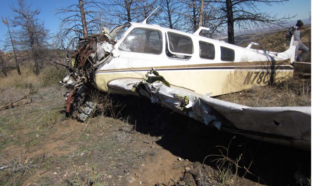
Photo: NTSB
Revision history:
| Date/time | Contributor | Updates |
|---|---|---|
| 13-Nov-2015 07:13 | Geno | Added |
| 13-Nov-2015 07:26 | gerard57 | Updated [Date] |
| 21-Dec-2016 19:30 | ASN Update Bot | Updated [Time, Damage, Category, Investigating agency] |
| 22-Mar-2019 19:07 | ASN Update Bot | Updated [Operator, Total occupants, Nature, Departure airport, Destination airport, Source, Narrative, Accident report, ] |
| 22-Mar-2019 19:54 | harro | Updated [Source, Narrative, Photo] |
Corrections or additions? ... Edit this accident description
The Aviation Safety Network is an exclusive service provided by:
Quick Links:
| ASN Home | Send Correction / Feedback |
| FSF Home | Disclaimer | Copyright |
| Contact Us | Privacy Policy |
| Press / Media |
 ©2024 Flight Safety Foundation