

ASN Wikibase Occurrence # 188709
This information is added by users of ASN. Neither ASN nor the Flight Safety Foundation are responsible for the completeness or correctness of this information.
If you feel this information is incomplete or incorrect, you can submit corrected information.
| Date: | Saturday 16 July 2016 |
| Time: | 18:45 |
| Type: |  Piper PA-28R-201 Arrow III |
| Owner/operator: | Private |
| Registration: | N2241Q |
| MSN: | 28R-7737029 |
| Year of manufacture: | 1977 |
| Total airframe hrs: | 6573 hours |
| Engine model: | Lycoming IO-360-C1C6 |
| Fatalities: | Fatalities: 3 / Occupants: 4 |
| Aircraft damage: | Destroyed |
| Category: | Accident |
| Location: | Near Hogan Airport (NY05), Esperance, NY -
 United States of America United States of America
|
| Phase: | Take off |
| Nature: | Private |
| Departure airport: | Esperance, NY (NY05) |
| New Haven, CT (HVN) | |
| Investigating agency: | NTSB |
| Confidence Rating: |
The private pilot and three passengers departed in the airplane from a 3,000-ft-long runway with a density altitude of about 3,000 ft and a light wind. Surveillance video showed that the airplane did not use the entire length of the runway for takeoff; the pilot began his takeoff roll where the paved section of the part turf/part asphalt runway began, resulting in 2,400 ft of available runway. During the ground roll, the nose of the airplane lifted off and then settled back onto the runway, and the airplane became airborne at 1,500 ft. Witnesses described the takeoff and initial climb as "slow" and "sluggish." The wings rocked, and the airplane climbed to about 100 ft in a continuous left turn before descending into trees 1,000 ft left of the runway centerline.
Examination of the airplane and its engine revealed no evidence of preimpact mechanical malfunction or anomaly. An estimate of the airplane's takeoff weight indicated that it was about 66 lbs over the maximum allowable takeoff weight of 2,750 pounds. Review of performance charts revealed that the takeoff ground roll distance for the airplane at the maximum allowable gross weight was about 2,180 ft. Review of radar data showed that from rotation to the final radar target, the airplane's groundspeed (which was about the same as its airspeed given the light wind) varied between 61 and 67 knots, which was about the airplane's calculated stall speed of 60 knots. Further, the witness observations were consistent with the pilot failing to attain sufficient airspeed, which resulted in the airplane's wing exceeding its critical angle of attack and an aerodynamic stall.
It is likely that the pilot lifted off prematurely at a speed lower than normal and was unable to accelerate or climb the airplane once it exited ground effect. A premature liftoff and a climb attempt at a speed significantly below best angle of climb speed (78 knots) placed the airplane in a situation where the power required for level flight was very near or exceeded the available power. To recover from this situation the pilot needed to lower the airplane's nose in order to accelerate the airplane to obtain a positive rate of climb. However, such an action is counterintuitive when low to the ground and requires accurate problem recognition, knowledge of the correct solution, and sufficient terrain clearance to accomplish.
Probable Cause: The pilot's inadequate preflight weight and balance and performance planning, which resulted in the airplane being over gross weight. Also causal were the pilot's decision not to use the entire runway for takeoff, his premature liftoff, and his failure to attain adequate airspeed, which resulted in the airplane exceeding its critical angle of attack and an aerodynamic stall.
Accident investigation:
 |
|
Sources:
NTSB
FAA register: http://registry.faa.gov/aircraftinquiry/NNum_Results.aspx?NNumbertxt=2241Q
Location
Images:
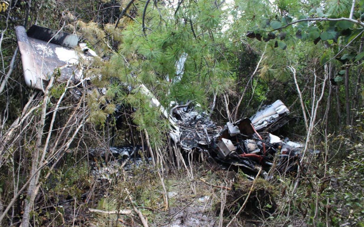
Photo: NTSB
Revision history:
| Date/time | Contributor | Updates |
|---|---|---|
| 17-Jul-2016 01:57 | Geno | Added |
| 17-Jul-2016 15:52 | Geno | Updated [Aircraft type, Total fatalities, Destination airport, Source, Narrative] |
| 17-Jul-2016 19:46 | Geno | Updated [Source] |
| 18-Jul-2016 19:02 | Geno | Updated [Aircraft type, Registration, Cn, Operator, Destination airport, Source] |
| 02-Aug-2016 06:29 | Anon. | Updated [Narrative] |
| 16-Dec-2017 14:53 | ASN Update Bot | Updated [Operator, Nature, Departure airport, Destination airport, Source, Narrative] |
| 16-Dec-2017 15:01 | harro | Updated [Source, Narrative, Photo, ] |
Corrections or additions? ... Edit this accident description
The Aviation Safety Network is an exclusive service provided by:
Quick Links:
| ASN Home | Send Correction / Feedback |
| FSF Home | Disclaimer | Copyright |
| Contact Us | Privacy Policy |
| Press / Media |
 ©2024 Flight Safety Foundation