

ASN Wikibase Occurrence # 189703
This information is added by users of ASN. Neither ASN nor the Flight Safety Foundation are responsible for the completeness or correctness of this information.
If you feel this information is incomplete or incorrect, you can submit corrected information.
| Date: | Tuesday 30 August 2016 |
| Time: | 18:01 |
| Type: |  Beechcraft A36 Bonanza |
| Owner/operator: | Flying Start Aero |
| Registration: | N985CA |
| MSN: | E-1901 |
| Year of manufacture: | 1981 |
| Total airframe hrs: | 5528 hours |
| Engine model: | Continental IO-550 |
| Fatalities: | Fatalities: 2 / Occupants: 2 |
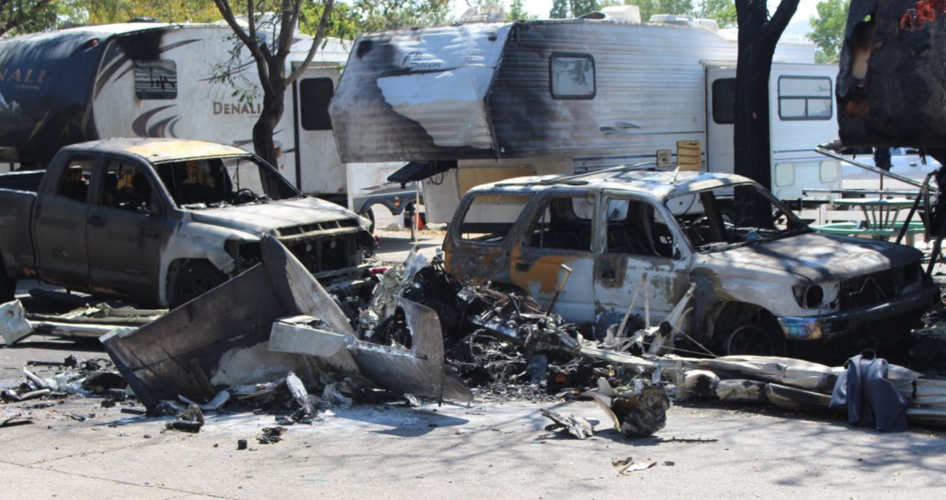
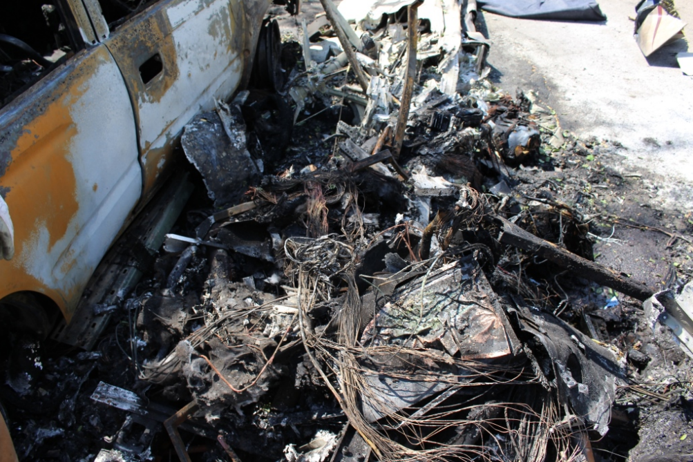
| Aircraft damage: | Destroyed |
| Category: | Accident |
| Location: | Sparks, NV -
 United States of America United States of America
|
| Phase: | Approach |
| Nature: | Private |
| Departure airport: | Henderson Executive Airport, NV (HND) |
| Reno/Tahoe International Airport, NV (RNO) | |
| Investigating agency: | NTSB |
| Confidence Rating: |
The 73-year-old commercial pilot was on the fourth and final leg of a 950-mile round trip same day flight. As the airplane neared the airport, the pilot was told by the air traffic controller to expect runway 25 for landing. After the controller informed him of a delay for that runway, the pilot stated that he could accept runway 16L; the pilot was told to proceed for runway landing, but the runway was not specified, an instruction which he acknowledged. Shortly after establishing contact with the tower controller, who instructed the pilot to continue for runway 25, the pilot reported that the airplane was on a downwind leg for landing on runway 16L. The controller acknowledged and, rather than correcting the pilot, instructed him to continue inbound for 16L. At the time, runway 16R was being used for landing by two Boeing 757 (B757) airplanes in sequence, separated from each other by about 7 miles. The controller advised the accident pilot that a B757 was on a 9-mile final for runway 16R and cautioned him about wake turbulence, then cleared the accident airplane to land. Shortly thereafter, the pilot reported that he had "the airliner" in sight. At this time, one of the B757s was on a short final approach for 16R, about 4.5 miles ahead of and below the accident airplane. The other B757, which was the potential conflict, was about 5 miles away from the accident airplane at its 2-to-3-o'clock position. Given that the pilot's attention was likely focused toward the runway during this portion of the approach, it is likely that he misidentified the ATC-reported traffic as the B757 on short final, which landed soon after and likely resulted in the pilot relaxing his vigilance in looking for traffic. Shortly thereafter, the controller issued an all-aircraft advisory that the wind was from 250° at 17 knots with gusts to 20 knots. Although these wind conditions met or exceeded the airplane's maximum demonstrated crosswind capability for a landing on 16L, and the airplane was still well-positioned to revert to an approach to runway 25, the pilot continued toward 16L.
About 70 seconds after the pilot reported sighting the traffic, just after turning the airplane onto the base leg of the traffic pattern, the B757 passed about 1 mile ahead of and about 100 ft below the accident airplane. The investigation was unable to determine whether the pilot saw that B757, or if he did, whether he was cognizant of the potential for a wake vortex encounter and the flight path alterations necessary to avoid such an encounter. The pilot made no radio communications or flight path adjustments to indicate that he saw the B757 or tried to avoid its wake.
According to witnesses, the airplane's flightpath appeared normal as it approached the runway for landing. When the airplane was on about a 1/2-mile final approach, at an altitude of less than 200 ft above ground level, it suddenly rolled and descended to the ground. Ground scars and debris distribution was consistent with a near-vertical descent and impact. Examination of the wreckage did not reveal any evidence of pre-impact mechanical deficiencies or malfunctions that would have precluded normal operation. A wake vortex analysis study revealed that the airplane most likely encountered the wake vortices that were generated by a B757 landing on the parallel, upwind runway. The vortices were of sufficient size and strength to radically upset the airplane at an altitude too low to recover.
Had the controller informed the pilot that there were two B757s on final approach for 16R, it is likely that the pilot's traffic situational awareness would have been more complete. The pilot likely would have altered his traffic scan or questioned ATC further to ensure that he had identified the correct B757. The pilot's radio communications did not indicate any doubt about whether he had properly identified his traffic, and in postaccident interviews, the controller stated that he was certain that the pilot had correctly identified it. Had either the controller or the pilot specified the location of the
Probable Cause: The pilot's selection of a landing runway which, given the wind and traffic conditions, was susceptible to high crosswinds and the translation of wake turbulence across its approach path, and the controller's and pilot's failure to ensure separation from the B757 and its wake, which resulted in a low-altitude encounter with wake vortices that the pilot was unable to recover from.
Accident investigation:
 |
|
Sources:
NTSB
FAA register: http://registry.faa.gov/aircraftinquiry/NNum_Results.aspx?nNumberTxt=985CA
Location
Images:

Photos(c): NTSB
Revision history:
| Date/time | Contributor | Updates |
|---|---|---|
| 31-Aug-2016 04:51 | Geno | Added |
| 31-Aug-2016 05:05 | Geno | Updated [Source] |
| 31-Aug-2016 15:51 | Geno | Updated [Registration, Cn, Operator, Total fatalities, Source, Narrative] |
| 31-Aug-2016 18:53 | gerard57 | Updated [Total fatalities, Total occupants, Source, Narrative] |
| 01-Sep-2016 09:27 | Iceman 29 | Updated [Embed code] |
| 18-Jul-2018 12:29 | Captain Adam | Updated [Departure airport, Source, Narrative] |
| 22-Jul-2018 18:49 | ASN Update Bot | Updated [Time, Operator, Nature, Departure airport, Destination airport, Source, Narrative] |
| 12-Mar-2022 23:25 | Captain Adam | Updated [Location, Nature, Departure airport, Destination airport, Source, Embed code, Narrative, Category, Photo] |
| 12-Mar-2022 23:25 | Captain Adam | Updated [Photo] |
| 12-Mar-2022 23:26 | Captain Adam | Updated [Photo] |
Corrections or additions? ... Edit this accident description
The Aviation Safety Network is an exclusive service provided by:
Quick Links:
| ASN Home | Send Correction / Feedback |
| FSF Home | Disclaimer | Copyright |
| Contact Us | Privacy Policy |
| Press / Media |
 ©2024 Flight Safety Foundation