

ASN Wikibase Occurrence # 201436
This information is added by users of ASN. Neither ASN nor the Flight Safety Foundation are responsible for the completeness or correctness of this information.
If you feel this information is incomplete or incorrect, you can submit corrected information.
| Date: | Friday 17 November 2017 |
| Time: | 12:06 LT |
| Type: |  Cessna 152 |
| Owner/operator: | Airways Aero Associations |
| Registration: | G-WACG |
| MSN: | 152-85536 |
| Fatalities: | Fatalities: 2 / Occupants: 2 |
| Other fatalities: | 2 |
| Aircraft damage: | Destroyed |
| Category: | Accident |
| Location: | Waddesdon near Aylesbury, Buckinghamshire -
 United Kingdom United Kingdom
|
| Phase: | En route |
| Nature: | Training |
| Departure airport: | Wycombe Air Park (HYC/EGTB) |
| Wycombe Air Park (HYC/EGTB) | |
| Investigating agency: | AAIB |
| Confidence Rating: |
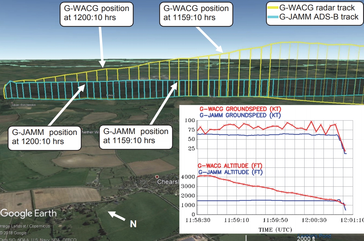
A Cessna 152 (G-WACG) and a Guimbal Cabri G-2 (G-JAMM) crashed following a mid-air collision near Aylesbury, England. Both occupants of the Cessna and both occupants of the Cabri helicopter, pilot and student, suffered fatal injuries.
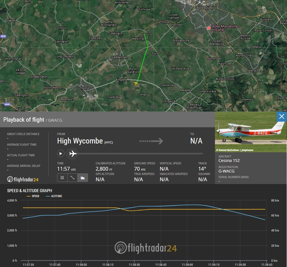
The Cessna departed Wycombe at 11:46 on a local training flight to practice 'best rate of climb' and 'glide descent' exercises. The aircraft climbed steadily up to an altitude of 2,000 ft before turning on course to the local training area northwest of the aerodrome. At 11:50 hrs G-WACG confirmed with Wycombe Tower that they had left the circuit area; there were no further radio communications from the aircraft. G-WACG reached 4,000 ft, turned left onto a steady north-westerly course and then commenced a sustained descent which continued until the point of collision. The collision occurred 14 minutes after takeoff from Wycombe.
The Cabri helicopter departed Wycombe at 11:47 on a local navigation exercise. The instructor in G-JAMM advised Wycombe Tower they were leaving the circuit to the north; there were no further radio communications from the helicopter. G-JAMM climbed to and maintained an altitude of around 1,500 ft amsl until the point of the collision.
AAIB Conclusion:
The geometry of the flight paths was such that the opportunity for the occupants of the two aircraft to ‘see and avoid’ each other was very limited. The damage sustained to each aircraft was such that neither could continue in controlled flight.
It is not known whether shallow turns were made during G-WACG’s descent from 4,000 ft and G-JAMM’s main rotor paint scheme would not have enhanced visual conspicuity when viewed from above.
As the separation between the two aircraft gradually reduced over several minutes, the use of compatible EC devices could have improved situational awareness such that avoiding action could be taken.
Accident investigation:
 |
|
Sources:
1. AAIB Final Report: https://assets.publishing.service.gov.uk/media/5bc733dae5274a361ac03dd4/Cessna_152_G-WACG_Guimbal_Cabri_G2_G-JAMM_11-18.pdf
2. https://www.gov.uk/government/news/the-aaib-is-sending-a-team-to-buckinghamshire
3. https://www.telegraph.co.uk/news/2017/11/17/aylesbury-mid-air-crash-fatalities-feared-afteraircraft-helicopter/
4. https://www.dailystar.co.uk/news/latest-news/660777/Aylesbury-crash-aircraft-helicopter-mid-air-collision-Buckinghamshire-M40-motorway
5. http://www.bbc.co.uk/news/uk-england-beds-bucks-herts-42024712 (update)
6. https://www.dailyrecord.co.uk/news/uk-world-news/victims-mid-air-helicopter-plane-11548434
7. https://www.flightradar24.com/data/aircraft/g-wacg#f8ec53d
8. http://publicapps.caa.co.uk/modalapplication.aspx?catid=1&pagetype=65&appid=1&mode=detailnosummary&fullregmark=WACG
9. https://www.jetphotos.com/photo/314711
10. https://www.flightradar24.com/data/aircraft/g-wacg#f8efef7
11. http://aerossurance.com/helicopters/mac-electronic-conspicuity/
12. G-JAMM : https://aviation-safety.net/wikibase/wiki.php?id=201438
Images:
Media:
Fatal mid-air collision, Buckinghamshire, 17 Nov 17 https://t.co/fvc4lZSBtw pic.twitter.com/vcy7gJdmML
— AAIB (@aaibgovuk) November 8, 2018
Four people confirmed dead in plane and helicopter collision near historic Waddesdon Manor https://t.co/4ojVRctDhy pic.twitter.com/xVhN92OSbM
— Daily Mirror (@DailyMirror) 17 novembre 2017
Revision history:
| Date/time | Contributor | Updates |
|---|---|---|
| 17-Nov-2017 14:16 | FERRYAIR | Added |
| 17-Nov-2017 14:17 | harro | Updated [Location, Narrative] |
| 17-Nov-2017 15:04 | Anon. | Updated [Source] |
| 17-Nov-2017 15:46 | Geno | Updated [Time, Location, Departure airport] |
| 17-Nov-2017 17:01 | dbabyak | Updated [Aircraft type, Registration, Cn, Source] |
| 17-Nov-2017 17:01 | Michael Roots | Updated [Aircraft type, Registration, Total fatalities, Total occupants, Other fatalities, Source] |
| 17-Nov-2017 17:06 | harro | Updated [Cn, Operator, Source, Damage, Narrative] |
| 17-Nov-2017 18:58 | Aerossurance | Updated [Time, Location] |
| 17-Nov-2017 19:42 | Anon. | Updated [Source] |
| 17-Nov-2017 19:56 | Iceman 29 | Updated [Embed code] |
| 17-Nov-2017 20:16 | Iceman 29 | Updated [Source, Embed code, Photo, ] |
| 17-Nov-2017 20:41 | Iceman 29 | Updated [Total fatalities, Total occupants, Source, Narrative] |
| 18-Nov-2017 12:03 | Iceman 29 | Updated [Source, Embed code] |
| 19-Nov-2017 19:35 | Iceman 29 | Updated [Source, Narrative] |
| 09-Nov-2018 15:03 | harro | Updated [Nature, Destination airport, Narrative, Photo, Accident report, ] |
| 11-Nov-2018 20:36 | Dr.John Smith | Updated [Source, Embed code, Narrative] |
| 24-Nov-2018 18:08 | Aerossurance | Updated [Source, Embed code] |
Corrections or additions? ... Edit this accident description
The Aviation Safety Network is an exclusive service provided by:
Quick Links:
| ASN Home | Send Correction / Feedback |
| FSF Home | Disclaimer | Copyright |
| Contact Us | Privacy Policy |
| Press / Media |
 ©2024 Flight Safety Foundation