

ASN Wikibase Occurrence # 203031
This information is added by users of ASN. Neither ASN nor the Flight Safety Foundation are responsible for the completeness or correctness of this information.
If you feel this information is incomplete or incorrect, you can submit corrected information.
| Date: | Friday 15 December 2017 |
| Time: | 18:38 LT |
| Type: |  Piper PA-23-250 Aztec |
| Owner/operator: | Private |
| Registration: | C-FIPK |
| MSN: | 27-8054059 |
| Fatalities: | Fatalities: 1 / Occupants: 1 |
| Aircraft damage: | Destroyed |
| Category: | Accident |
| Location: | 5.2 NM E of Baldur, MB -
 Canada Canada
|
| Phase: | Approach |
| Nature: | Private |
| Departure airport: | Gillam Airport, MB (YGX/CYGX) |
| Baldur private landing strip, MB | |
| Investigating agency: | TSB |
| Confidence Rating: |
On 15 December 2017, the privately registered Piper PA-23-250 Aztec was conducting a visual flight rules flight from Gillam Airport (CYGX), Manitoba, to an unlighted private aerodrome located 5.25 nautical miles (nm) east of Baldur, Manitoba, with only the pilot on board.
On the day of the occurrence, the pilot had departed from the private aerodrome at approximately 1130 with a full fuel load. His plan was to fly to Dauphin Airport (CYDN), Manitoba, and then continue on to CYGX before returning to the private aerodrome later that same day.
Shortly after arrival at CYGX, the pilot requested that the wing-tip fuel tanks be filled, taking on 160 L (42 U.S. gallons) of fuel. While the pilot was at CYGX, a family member texted the pilot to inform him that snow was causing poor visibility at the private aerodrome and that an increase in wind speed and gusts was expected at his estimated time of arrival. Consequently, the pilot decided to fly to Winnipeg/James Armstrong Richardson International Airport (CYWG), Manitoba, instead, which is located approximately 78 nm northeast of the private aerodrome and 51 nm closer to CYGX.
The aircraft departed CYGX at 15:50 and climbed to 9000 feet above sea level (ASL) on a direct track to CYWG. At 17:15, when the aircraft was approximately 174 nm from CYWG, the pilot altered course to a southwest heading that would take him directly to the private aerodrome.
At approximately 17:45, the pilot received a text message from the same family member indicating that, before dark, the visibility at the private aerodrome had been about ¾ statute mile (sm) in snow. About half an hour later, the pilot made arrangements with the family member to make vehicle tracks on the runway and then place the vehicle at the north end of the private aerodrome with the headlights pointing to the south. Shortly thereafter, the pilot was informed that the wind was about 10 to 15 knots and that the tracks had been made on the runway. Snow was still falling and there were now about 3 inches of snow on the runway.
At 18:34, the aircraft began to descend from its cruising altitude at a rate of approximately 1550 feet per minute. When it was roughly 0.87 nm northeast of the private aerodrome, the aircraft levelled off briefly at approximately 400 feet above ground level (AGL), before resuming the descent. The aircraft descended through 200 feet AGL immediately prior to crossing over the middle of the private aerodrome, on a southwest heading. As the aircraft passed overhead, the family member drove the vehicle to the north end of the runway, expecting that the pilot would circle to the north before returning to land. However, immediately after overflying the private aerodrome, the aircraft descended into a small valley following sloping terrain.
At 18:38, in the hours of darkness the aircraft crashed on a frozen marsh in the bottom of the valley. The pilot received fatal injuries. There was no fire. The 406 MHz emergency locator transmitter (ELT) activated; however, the Cospas-Sarsat system did not detect a signal.
Accident investigation:
 |
|
Sources:
http://winnipegsun.com/news/provincial/pilot-dies-in-plane-crash-near-baldur
https://www.winnipegfreepress.com/local/60-year-old-pilot-dies-in-rural-manitoba-plane-crash-464669323.html
http://wwwapps.tc.gc.ca/saf-sec-sur/2/ccarcs-riacc/ADet.aspx?id=16962&rfr=RchSimp.aspx
Images:
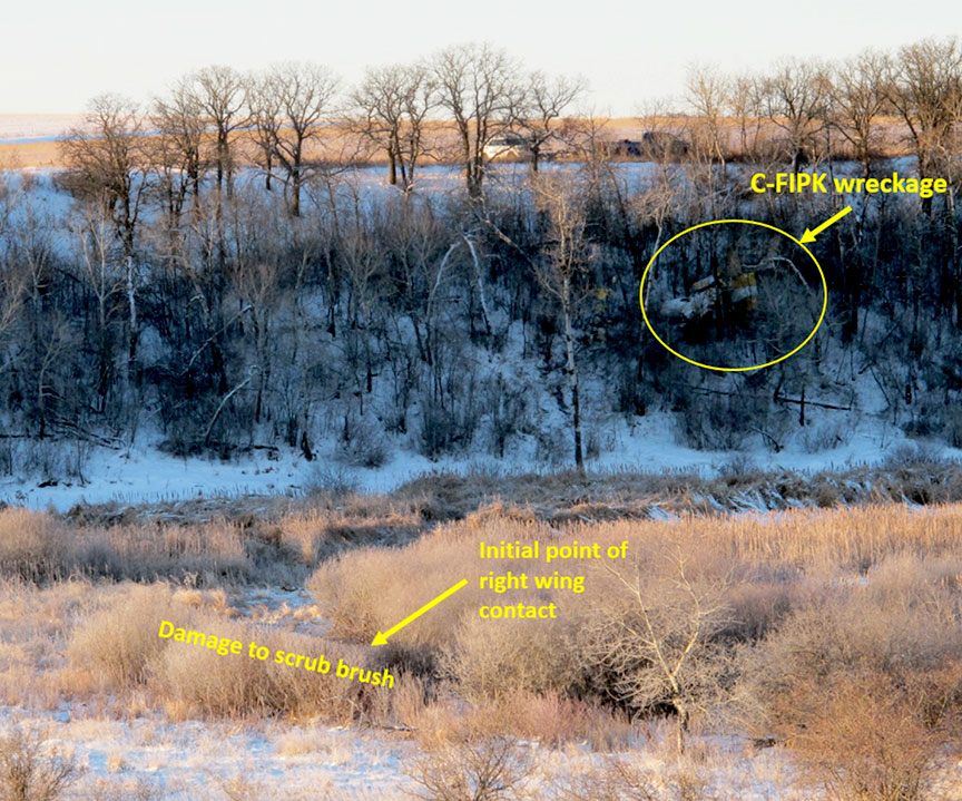
Photo: TSB
Revision history:
| Date/time | Contributor | Updates |
|---|---|---|
| 17-Dec-2017 02:41 | Geno | Added |
| 17-Dec-2017 03:05 | Geno | Updated [Aircraft type, Registration, Cn, Operator, Source, Narrative] |
| 17-Dec-2017 08:26 | Iceman 29 | Updated [Embed code] |
| 22-Dec-2017 21:01 | Anon. | Updated [Embed code] |
| 05-Jan-2018 19:30 | harro | Updated [Registration, Location, Narrative] |
| 03-May-2018 17:48 | harro | Updated [Time, Phase, Nature, Departure airport, Destination airport, Damage, Narrative] |
| 03-May-2018 17:51 | harro | Updated [Source, Embed code, Photo, ] |
| 25-Oct-2023 14:53 | harro | Updated [[Source, Embed code, Photo, ]] |
Corrections or additions? ... Edit this accident description
The Aviation Safety Network is an exclusive service provided by:
Quick Links:
| ASN Home | Send Correction / Feedback |
| FSF Home | Disclaimer | Copyright |
| Contact Us | Privacy Policy |
| Press / Media |
 ©2024 Flight Safety Foundation