

ASN Wikibase Occurrence # 220904
This information is added by users of ASN. Neither ASN nor the Flight Safety Foundation are responsible for the completeness or correctness of this information.
If you feel this information is incomplete or incorrect, you can submit corrected information.
| Date: | Thursday 17 January 2019 |
| Time: | 16:45 |
| Type: |  Piper PA-23-250 Aztec E |
| Owner/operator: | Private |
| Registration: | N14372 |
| MSN: | 23-7304961 |
| Year of manufacture: | 1972 |
| Total airframe hrs: | 4795 hours |
| Engine model: | Lycoming TIO-540 |
| Fatalities: | Fatalities: 1 / Occupants: 1 |
| Aircraft damage: | Destroyed |
| Category: | Accident |
| Location: | near Bowers Field Airport (KELN), Ellensburg, WA -
 United States of America United States of America
|
| Phase: | Initial climb |
| Nature: | Private |
| Departure airport: | Ellensburg-Bowers Field, WA (ELN/KELN) |
| Yakima Air Terminal, WA (YKM/KYKM) | |
| Investigating agency: | NTSB |
| Confidence Rating: |
On January 17, 2019, at 1645 Pacific standard time, a Piper PA23-250 airplane, N14372, was destroyed when it was involved in an accident near Ellensburg, Washington. The pilot was fatally injured. The airplane was operated as a Title 14 Code of Federal Regulations (CFR) Part 91 personal flight. The flight originated from Bowers Field Airport (ELN), Ellensburg, Washington, about 1639, and was destined for McAllister Field Airport (YKM), Yakima, Washington, located about 28 nautical miles south.
The instrument rated pilot departed into marginal visual flight rules conditions between sunset and the end of civil twilight. Shortly after takeoff, he contacted air traffic control and stated that he was in the clouds at 5,000 ft mean sea level (msl) and requested an instrument landing system approach at the destination airport. The controller issued the airplane a discrete transponder code and asked the pilot if he wanted an IFR clearance; however, the pilot did not respond, and no further communications were received from the airplane. Radar data showed that the airplane entered a descending left turn before radar contact was lost about 3,050 ft msl. Witnesses and surveillance video indicated that the airplane descended out of the clouds in a steep, nose-low attitude and impacted terrain. The extensive fragmentation of the wreckage precluded a thorough examination of the airplane's flight controls, instruments, and other systems; however, no anomalies were noted during examination of the engines.
AIRMETs for instrument flight rules (IFR), mountain obscuration, turbulence, and icing conditions were all valid for the area of the accident site at the time of the accident. Both the departure and destination airports reported overcast ceilings below 2,000 ft above ground level about the time of the accident, with surface temperatures just above freezing. An atmospheric sounding indicated a high potential for light rime icing and moderate turbulence at 5,000 ft in the vicinity of the accident site, and radar imagery suggested clouds and potential light icing conditions. There was no evidence that the pilot obtained a weather briefing before departure.
Although impact damage precluded a thorough examination of the airplane's flight instruments, the restricted visibility and lighting conditions present at the time were conducive to the development of spatial disorientation, and the airplane's descending turn and high-energy impact are consistent with the known effects of spatial disorientation.
Probable Cause: The instrument rated pilot’s loss of control due to spatial disorientation.
Accident investigation:
 |
|
Sources:
NTSB
https://registry.faa.gov/aircraftinquiry/NNum_Results.aspx?NNumbertxt=14372
https://flightaware.com/live/flight/N14372
Location
Images:
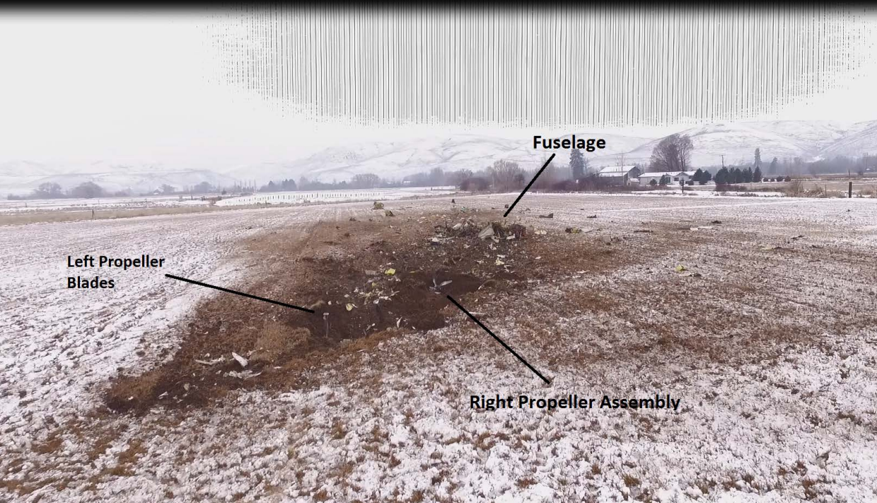
Photo: NTSB
Revision history:
| Date/time | Contributor | Updates |
|---|---|---|
| 18-Jan-2019 06:06 | Geno | Added |
| 18-Jan-2019 06:06 | Geno | Updated [Location] |
| 18-Jan-2019 22:54 | Iceman 29 | Updated [Aircraft type, Destination airport, Source] |
| 19-Jan-2019 00:09 | RobertMB | Updated [Aircraft type, Registration, Cn, Operator, Location, Phase, Nature, Source] |
| 19-Jan-2019 05:35 | Geno | Updated [Destination airport, Source] |
| 19-Jan-2019 08:56 | Iceman 29 | Updated [Source, Damage] |
| 31-Mar-2021 14:15 | harro | Updated [Date] |
| 31-Mar-2021 14:15 | ASN Update Bot | Updated [Time, Other fatalities, Source, Damage, Narrative, Category, Accident report] |
| 31-Mar-2021 14:28 | harro | Updated [Date, Source, Narrative] |
Corrections or additions? ... Edit this accident description
The Aviation Safety Network is an exclusive service provided by:
Quick Links:
| ASN Home | Send Correction / Feedback |
| FSF Home | Disclaimer | Copyright |
| Contact Us | Privacy Policy |
| Press / Media |
 ©2024 Flight Safety Foundation