

ASN Wikibase Occurrence # 221600
This information is added by users of ASN. Neither ASN nor the Flight Safety Foundation are responsible for the completeness or correctness of this information.
If you feel this information is incomplete or incorrect, you can submit corrected information.
| Date: | Tuesday 5 February 2019 |
| Time: | 18:15 |
| Type: |  Cessna 172M Skyhawk |
| Owner/operator: | Flying Academy Los Angeles |
| Registration: | N20556 |
| MSN: | 17261391 |
| Year of manufacture: | 1973 |
| Total airframe hrs: | 6954 hours |
| Engine model: | Lycoming O-320 SERIES |
| Fatalities: | Fatalities: 2 / Occupants: 2 |
| Aircraft damage: | Destroyed |
| Category: | Accident |
| Location: | Desert Hot Springs, CA -
 United States of America United States of America
|
| Phase: | En route |
| Nature: | Private |
| Departure airport: | El Monte-San Gabriel Valley Airport, CA (EMT/KEMT) |
| Las Vegas-North Las Vegas Airport, NV (VGT/KVGT) | |
| Investigating agency: | NTSB |
| Confidence Rating: |
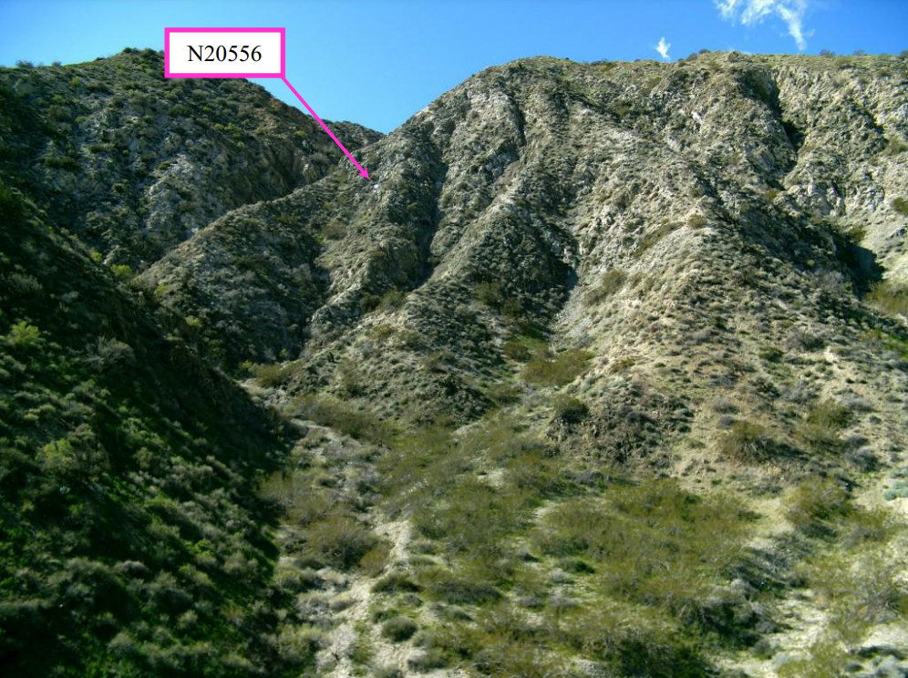
On February 5, 2019, about 1815 Pacific standard time, a Cessna 172M airplane, N20556, impacted mountainous terrain near Desert Hot Springs, California while on a cross-country flight to North Las Vegas Airport (VGT), Las Vegas, Nevada. The commercial pilot and his non pilot-rated passenger received fatal injuries, and the airplane was destroyed. The airplane was registered to Flying Academy Los Angeles (FALA), and was being operated as a 14 Code of Federal Regulations Part 91 personal flight. Undetermined night meteorological conditions existed at the impact location at the time of the accident. The accident flight leg had originated from San Gabriel Valley Airport (EMT), El Monte, California.
On the day of the accident, the pilot departed for a cross-country flight with full fuel and landed at another airport about 24 miles to the west about 80 minutes later. The pilot picked up a passenger there and then took off.
About 7 minutes after takeoff, the pilot contacted air traffic control (ATC) to acquire visual flight rules flight- following services at a planned en route altitude of 3,500 ft. The pilot advised that he would "follow the road" as his means of navigation. The airplane continued toward the destination and radar data revealed that for the majority of the flight, the airplane remained at an altitude of 3,500 ft. During this period, the groundspeed varied irregularly, ranging from about 95 to 123 knots. At the east end of a mountain pass, the groundspeed had increased to about 135 knots and remained there until the airplane completed a turn north when the airplane began a steady climb of about 600 fpm. The airplane reached a peak altitude of 4,100 ft, and then began a steady descent of about 1,325 fpm where it appeared to momentarily level off at an altitude of 2,775 ft, and radar contact was lost about 9 seconds later. Just prior to the loss of radar contact, the groundspeed decreased irregularly to about 96 knots, and then increased gradually to about 103 knots by the end of the data. Radar contact was reestablished for a short time with the final radar return recorded at an altitude of about 2,800 ft. and depicted the airplane position as about 1,500 ft southeast of the impact location.
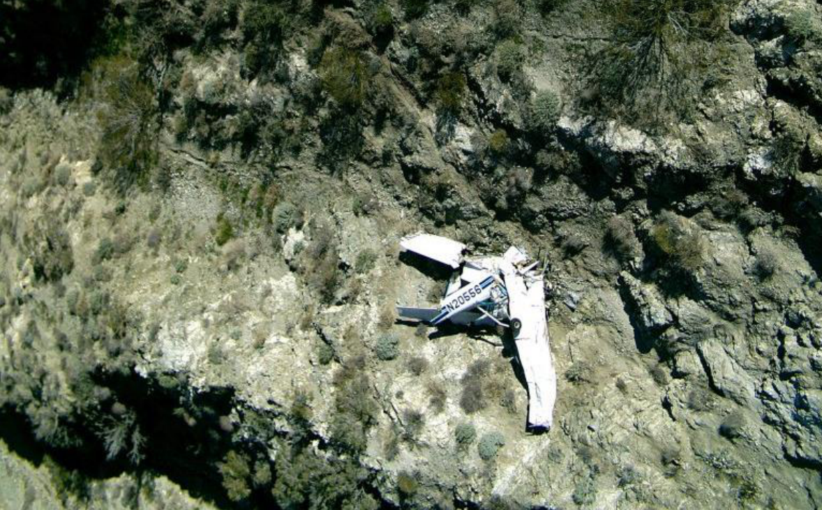
The airplane impacted a steep mountain face at an elevation of about 2,500 ft while the pilot was attempting to negotiate a north-south mountain pass with peak terrain elevations of about 2,700 ft. On scene information indicated that the airplane impacted in a wings-level attitude with a significant horizontal speed component. Propeller and engine damage indicated that the engine was developing power at the time of impact. Examination of the airframe and engine did not reveal any pre-impact mechanical deficiencies or failures that would have precluded continued flight.
The investigation was unable to determine if the pilot evaluated the weather prior to his departure. Satellite imagery showed higher terrain obscured by clouds, but the pass and accident location were free of cloud cover. However, the region, particularly that near the accident site, was experiencing high winds, generally out of the west, and significant turbulence. Thus, the airplane was on the leeward side of the slopes, where downdraft activity, with potential speeds over 1,000 fpm, would be expected .
The airplane’s altitude deviations as it navigated the north/south pass were consistent with the airplane encountering significant up- and downdrafts. The pilot’s selected en route altitude of 3,500 ft was too low for the pass that he was transiting, and physically impossible for the route options beyond, regardless of the wind conditions. There were no cloud ceilings or airspace restrictions that would have prevented the pilot from operating at a higher cruise altitude, which would have provided the necessary terrain clearance. For the last 2 minutes of the flight, the airplane exhibited significant altitude excursions, likely as a result of atmospheric
disturbances. During the final minute of the flight, the airplane appears to have been affected by a strong
downdraft that the pilot either did not recognize or was unable to counter.
The most significant flawed decision was the pilot's selection of the incorrect low enroute altitude, which suggested either lack of or inadequate preflight planning. The pilot's improper low altitude choice, combined with the high terrain, strong winds, downdrafts, and limited climb capability of the airplane left little or no margin for ensuring terrain clearance and safe transit through the pass.
Probable Cause The pilot's inadequate and/or improper preparation for the flight in which he selected an altitude too low to assure terrain clearance and resulted in an impact with terrain in turbulent downdraft conditions.
Accident investigation:
 |
|
Sources:
https://www.desertsun.com/story/news/traffic/2019/02/06/plane-crash-near-morongo-valley-closing-part-highway-62/2788438002/
https://www.kesq.com/news/plane-crashes-near-morongo-valley/1003339621
https://patch.com/california/palmdesert/second-body-pulled-plane-crash-near-palm-springs
NTSB
https://registry.faa.gov/aircraftinquiry/NNum_Results.aspx?NNumbertxt=N20556%20
https://www.airliners.net/photo/Flying-Academy/Cessna-172M-Skyhawk/5095717 (photo)
Location
Images:
Photos: NTSB
Revision history:
| Date/time | Contributor | Updates |
|---|---|---|
| 06-Feb-2019 16:58 | Captain Adam | Added |
| 06-Feb-2019 17:00 | harro | Updated [Aircraft type, Registration, Cn, Operator, Total fatalities, Source, Damage] |
| 06-Feb-2019 18:19 | harro | Updated [Date] |
| 06-Feb-2019 20:33 | Geno | Updated [Departure airport, Destination airport, Source] |
| 07-Feb-2019 12:49 | RobertMB | Updated [Aircraft type] |
| 09-Feb-2019 01:24 | Geno | Updated [Total fatalities, Total occupants, Source, Narrative] |
| 11-Feb-2019 20:29 | MikeF | Updated [Location, Narrative] |
| 01-May-2019 19:59 | Captain Adam | Updated [Damage, Narrative] |
| 15-Apr-2022 09:01 | aaronwk | Updated [Phase, Departure airport, Source, Narrative] |
| 15-Apr-2022 09:02 | harro | Updated [Accident report] |
| 07-May-2023 21:23 | Captain Adam | Updated [[Accident report]] |
Corrections or additions? ... Edit this accident description
The Aviation Safety Network is an exclusive service provided by:
Quick Links:
| ASN Home | Send Correction / Feedback |
| FSF Home | Disclaimer | Copyright |
| Contact Us | Privacy Policy |
| Press / Media |
 ©2024 Flight Safety Foundation