

ASN Wikibase Occurrence # 231757
This information is added by users of ASN. Neither ASN nor the Flight Safety Foundation are responsible for the completeness or correctness of this information.
If you feel this information is incomplete or incorrect, you can submit corrected information.
| Date: | Saturday 28 December 2019 |
| Time: | 09:21 |
| Type: |  Piper PA-31T Cheyenne II |
| Owner/operator: | Cheyenne Partners LLC |
| Registration: | N42CV |
| MSN: | 31T-8020067 |
| Year of manufacture: | 1980 |
| Total airframe hrs: | 5954 hours |
| Engine model: | Pratt & Whitney Canada PT6A-27-28 |
| Fatalities: | Fatalities: 5 / Occupants: 6 |
| Aircraft damage: | Destroyed |
| Category: | Accident |
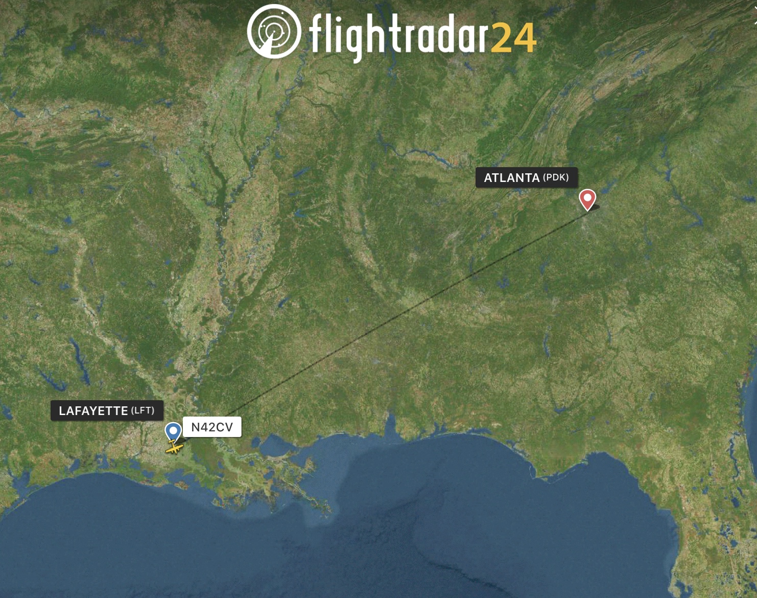
| Location: | near Lafayette Regional Airport (LFT/KLFT), LA -
 United States of America United States of America
|
| Phase: | Initial climb |
| Nature: | Private |
| Departure airport: | Lafayette Regional Airport, LA (LFT/KLFT) |
| Atlanta-DeKalb Peachtree Airport, GA (PDK/KPDK) | |
| Investigating agency: | NTSB |
| Confidence Rating: |
The personal flight departed from Lafayette Regional Airport/Paul Fournet Field (LFT), Lafayette, Louisiana, and entered the clouds when the airplane was at an altitude of about 200 ft above ground level. Before takeoff, the controller issued an instrument flight rules clearance to the pilot, instructing him to turn right onto a heading of 240° and climb to and maintain an altitude of 2,000 ft mean sea level (msl) after takeoff. Automatic dependent surveillance-broadcast (ADS-B) data for the accident flight started at 0920:05, and aircraft performance calculations showed that the airplane was climbing through an altitude of 150 ft msl at that time. The calculations also showed that the airplane then turned slightly to the right toward the assigned heading of 240° and climbed at a rate that varied between 1,000 and 2,400 ft per minute and an airspeed that increased from about 151 to 165 knots.
At 0920:13, the airplane started rolling back toward wings level and, 7 seconds later, rolled through wings level and toward the left. At that time, the airplane was tracking 232° at an altitude of 474 ft and an airspeed of 165 knots. The airplane’s airspeed remained at 165 knots for about 10 seconds before it started increasing again, and the airplane continued to roll steadily to the left at an average roll rate of about 2° per second.
The aircraft performance calculations further showed that, at 0920:40, the airplane reached a peak altitude of 925 ft msl. At that time, the airplane was tracking 200°, its bank angle was about 35° to the left, and its airspeed was about 169 knots. The airplane then started to descend while the left roll continued. At 0920:55, the airplane reached a peak airspeed of about 197 knots, which then started decreasing. At 0920:57, the airplane descended through 320 ft at a rate of descent of about 2,500 ft per minute and reached a bank angle of 75° to the left.
At 0920:58, the controller issued a low altitude alert, stating that the pilot should “check [the airplane’s] altitude immediately” because the airplane appeared to be at an altitude of 300 ft msl. The pilot did not respond, and no mayday or emergency transmission was received from the airplane. The last ADS-B data point was recorded at 0920:59; aircraft performance calculations showed that, at that time, the airplane was descending through an altitude of 230 ft msl at a flightpath angle of about -7°, an airspeed of 176 knots, and a rate of descent of about 2,300 ft per minute. (The flightpath angle is in the vertical plane—that is, relative to the ground. The ground track, as discussed previously, is in the horizontal plane—that is, relative to north.)
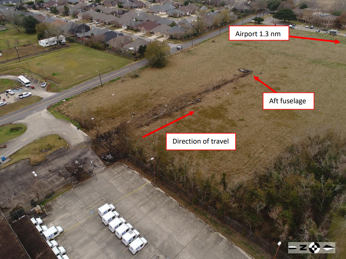
The airplane struck trees and power lines before striking the ground, traveled across a parking lot, and struck a car. The car rolled several times and came to rest inverted at the edge of the parking lot, and a postcrash fire ensued. The airplane continued to travel, shedding parts before coming to rest at the far end of an adjacent field. At the accident site, the surviving passenger told a local police officer that “the plane went straight up and then straight down."
Weight and balance calculations showed that the airplane’s total weight and center of gravity were within limits, with the center of gravity near the aft limit.
The pilot likely obtained weather information for the flight about 0736 on the day of the accident. This information indicated that low-visibility conditions would be present at the time of takeoff. The pilot would most likely have been aware of these conditions because, according to his wife, he had mentioned (on the night before the accident flight) that cloud ceilings would be “low” during takeoff. In addition, the pilot told the controller that he had the current automatic terminal information service report, which was based on the 0853 automated surface observing system observation. That observation indicated a visibility of 0.75 mile in mist and a vertical visibility of 200 ft above ground level. These weather conditions were conducive to the development of spatial disorientation.
The surviving passenger also recalled that the airplane “pitched up like the pilot was trying to get above or over the clouds” and that a “harder than normal pitching movement” had occurred. Thus, the pilot had likely become spatially disoriented at this point in the initial climb due to the lack of visual references and the airplane’s increasing pitch attitude. Another indication that the pilot had become spatially disoriented was the airplane’s continuing and tightening turn to the left away from the intended course.
The pilot’s most recent recurrent training in the airplane occurred in April 2019, but the training was conducted by a pilot whose Federal Aviation Administration-issued flight instructor certificate had expired in February 2019. No Federal Aviation Administration records indicated that the flight instructor’s certificate had been reinstated at the time of the training event. (The National Transportation Safety Board [NTSB] recognizes that the accident pilot might not have been aware that the flight instructor’s certificate had expired.) The flight instructor stated that the accident pilot’s training was conducted in visual meteorological conditions and that he did not simulate instrument conditions by having the pilot wear a hood (a view-limiting device). Further, the available pilot logbook evidence did not note the accident pilot’s recent flight experience or flight time in instrument meteorological conditions. As a result, the NTSB was unable to determine if the accident pilot met the regulatory requirements in Title 14 Code of Federal Regulations 61.57(c)(1) for instrument experience.
The left and right engines were impact and fire damaged. The damage to the turbine engine blades and shrouds was consistent with operation at the time of impact. No anomalies were found that would have precluded normal operation of both engines.
The damage to the propellers was symmetrical and consistent with impact forces. In addition, surveillance cameras at two private residences captured the sounds of the accident airplane as it passed overhead. No abnormal propeller sounds were heard on either recording. The NTSB’s sound spectrum analysis of the audio recording from one of these residences found that the recorded passing frequency was consistent with a four-bladed propeller rotating between 2,000 and 2,100 rpm, which was just below the propeller’s maximum continuous and takeoff allowable speed of 2,200 rpm.
Aircraft performance calculations showed that each engine’s horsepower began decreasing from 500 horsepower at 0920:55, consistent with the decrease in airspeed after that time. The left engine torque gauge needle, as found in the wreckage, pointed to a value of about 525 lb-ft. This torque level, at a propeller speed between 2,000 and 2,100 rpm, would produce about 200 horsepower, indicating a power reduction on both engines during the last 5 seconds of flight. At that time, the airplane would have been descending through the clouds. The performance calculations indicated that the power applied to the airplane after 0920:56 would have been negligible.
The airplane was not equipped, and was not required to be equipped, with a flight data recorder or a cockpit voice recorder. As a result, to determine the operational status of the autopilot during the accident flight, the NTSB conducted examinations of the annunciator panel and the autopilot servos. An analysis of light bulb filaments from the annunciator panel showed that none of the filaments from the autopilot, yaw damper, and flight director light bulbs were stretched, indicating that these annunciators were likely not illuminated at the time of impact. None of the examined autopilot servo components had failed, and no witness marks were noted on the gear teeth of the autopilot roll servo, indicating that the servos were not engaged at the time of impact. The annunciator panel and autopilot servo evidence was consistent with information provided by pilots who were familiar with the accident pilot. Specifically, the company owner reported that the accident pilot would hand fly the airplane up to an altitude of at least 2,000 ft, and the flight instructor stated that the accident pilot “was not an autopilot pilot” because he enjoyed hand flying the airplane. These statements, along with the physical evidence, indicated that the autopilot was likely not engaged during the accident flight.
Even though there were no maintenance writeups or reported anomalies with the flight deck display system before the accident flight, the NTSB considered whether the airplane’s attitude heading and reference system (AHRS) unit failed or malfunctioned during the accident flight, which could have caused erroneous attitude and heading information to be displayed to the pilot. The AHRS manufacturer successfully completed initial continuity tests of the AHRS. However, after the unit was connected to the test bench and power was applied, the test equipment was unable to communicate with the AHRS to conduct additional tests, which precluded a determination about the AHRS’ functionality at the time of the accident. Further, the information that was recorded and stored in the AHRS had been overwritten by the test equipment. Afterward, the NTSB conducted a visual inspection of the AHRS and discovered a dislodged internal connector, which was not detected during the NTSB’s initial inspection of the unit (before the manufacturer’s testing). The internal connector, which likely became dislodged as a result of impact forces, might have contributed to the manufacturer’s inability to conduct AHRS bench testing.
Because no recorded data were available to show the functionality of the AHRS unit, the NTSB was unable to determine the attitude and heading information displayed to the pilot during the flight. However, if an internal AHRS sensor had failed and a loss of attitude and heading information had occurred, red “X” flags would have appeared on the flight deck displays to prevent the pilot from referencing erroneous data. In that case, the standby digital attitude indicator, which was located directly beneath the flight deck displays, would have provided independent attitude and heading information to the pilot.
Because the left and right elevator trim tabs were found in their full airplane-nose-up setting, the pitch trim servo was bench tested to determine if the servo was functioning properly. The servo actuator passed the manual and auto-trim tests of the manufacturer’s acceptance test procedure but did not pass the torque test. During that test, the actuator rotated but skipped because the solenoid plunger did not fully engage with the gears. No evidence showed actuator gear teeth wear due to the teeth not engaging fully, indicating that the actuator was likely not skipping during the accident flight.
The left and right horizontal stabilizers and their respective elevators were found fragmented throughout the debris field. When these structures separated from the airplane, the elevator trim cables and elevator trim tabs were likely pulled in the airplane-nose-up direction. Thus, the elevator trim tabs were found in their full airplane-nose-up position likely as a result of the airplane’s impact and subsequent breakup.
The angle-of-attack sensor and the stability augmentation system computer failed portions of their respective functional tests. Although the manufacturer stated that the test results were typical of incoming in-use units, the NTSB was unable to determine the systems’ functionality at the time of the accident. However, these components likely did not contribute to the loss of control; the stability augmentation system is a pitch stability system, and the aircraft performance calculations showed that the airplane’s bank angle progressed continuously from about 13° right at 0920:13 to about 75° left at 0920:57. (Note: the stability augmentation system is further discussed in the NTSB Systems Group Chairman’s Factual Report in the docket for this accident. https://data.ntsb.gov/Docket?ProjectID=100739)
The stall margin indicator needle (part of the stability augmentation system) was found pointing to the red and black stall warning area. However, the needle had likely moved to that position during the impact sequence given the results of the aircraft performance calculations. Specifically, the flaps-up lift coefficient calculations for the accident flight showed that the airplane remained below the maximum flaps-up lift coefficient (the value of the lift coefficient just before the wing stalls and loses lift) during the period in which ADS-B data were recorded, indicating that an aerodynamic stall did not occur.
CEN20MA044In summary, postaccident examination of the airplane structures and systems revealed no anomalies that would have precluded normal operation. The weather conditions at the time of takeoff were conducive to the development of spatial disorientation. The lack of visual references and the airplane’s increasing pitch attitude likely caused the pilot to become spatially disoriented during the initial climb, as evidenced by the airplane’s continuing and tightening turn to the left away from the intended course. Thus, the pilot’s spatial disorientation led to his loss of control of the airplane.
Probable Cause: The pilot’s loss of airplane control due to spatial disorientation during the initial climb in instrument meteorological conditions.
Accident investigation:
 |
|
Sources:
https://www.katc.com/news/front-range/lafayette/plane-crashes-along-feu-follet-road
https://www.klfy.com/local/plane-crashes-near-verot-school-road-post-office/
https://www.ajc.com/news/breaking-plane-reportedly-crashes-louisiana/pNarcYAcMr1UDsx8JxK2YK/
NTSB
https://www.flightradar24.com/data/aircraft/n42cv#23567e44
https://registry.faa.gov/aircraftinquiry/NNum_Results.aspx?NNumbertxt=42CV
http://www.airport-data.com/images/aircraft/small/000/595/595570.jpg (photo)
Location
Images:


Photos: NTSB
Media:
NTSB issues the preliminary report, Tuesday, January 7, 2020, on its ongoing accident investigation of the December 28, 2019 crash in Lafayette, Louisiana involving a Piper PA-31T https://t.co/jranxKQhcs.
— NTSB_Newsroom (@NTSB_Newsroom) January 7, 2020
Revision history:
| Date/time | Contributor | Updates |
|---|---|---|
| 28-Dec-2019 16:26 | Geno | Added |
| 28-Dec-2019 16:44 | Geno | Updated [Time, Source, Narrative] |
| 28-Dec-2019 17:05 | Captain Adam | Updated [Total fatalities, Total occupants, Other fatalities, Source, Narrative] |
| 28-Dec-2019 17:27 | harro | Updated [Time, Aircraft type, Registration, Cn, Phase, Source] |
| 28-Dec-2019 17:30 | harro | Updated [Operator, Total occupants, Source] |
| 28-Dec-2019 17:31 | harro | Updated [Embed code] |
| 28-Dec-2019 17:36 | Aerossurance | Updated [Location, Embed code, Narrative] |
| 28-Dec-2019 17:36 | Aerossurance | Updated [Embed code] |
| 28-Dec-2019 17:42 | harro | Updated [Departure airport, Destination airport] |
| 28-Dec-2019 18:01 | RobertMB | Updated [Aircraft type, Location, Nature, Source, Narrative] |
| 28-Dec-2019 18:40 | harro | Updated [Narrative] |
| 28-Dec-2019 23:20 | Iceman 29 | Updated [Embed code, Narrative] |
| 29-Dec-2019 06:49 | Iceman 29 | Updated [Source, Embed code] |
| 29-Dec-2019 06:59 | Iceman 29 | Updated [Embed code, Photo] |
| 29-Dec-2019 06:59 | Iceman 29 | Updated [Photo] |
| 29-Dec-2019 08:08 | TB | Updated [Location, Embed code] |
| 07-Jan-2020 19:53 | Iceman 29 | Updated [Source, Narrative] |
| 07-Jan-2020 19:53 | Iceman 29 | Updated [Embed code] |
| 07-Jan-2020 19:54 | Iceman 29 | Updated [Embed code] |
| 29-May-2022 11:54 | Captain Adam | Updated [Time, Location, Source, Embed code, Narrative, Category, Accident report, Photo] |
| 29-May-2022 11:56 | Captain Adam | Updated [Photo] |
| 29-May-2022 19:02 | harro | Updated [[Photo]] |
Corrections or additions? ... Edit this accident description
The Aviation Safety Network is an exclusive service provided by:
Quick Links:
| ASN Home | Send Correction / Feedback |
| FSF Home | Disclaimer | Copyright |
| Contact Us | Privacy Policy |
| Press / Media |
 ©2024 Flight Safety Foundation