

ASN Wikibase Occurrence # 232468
This information is added by users of ASN. Neither ASN nor the Flight Safety Foundation are responsible for the completeness or correctness of this information.
If you feel this information is incomplete or incorrect, you can submit corrected information.
| Date: | Sunday 26 January 2020 |
| Time: | 11:45 LT |
| Type: |  Sikorsky S-76B |
| Owner/operator: | Island Express Holding Corp |
| Registration: | N72EX |
| MSN: | 760379 |
| Year of manufacture: | 1991 |
| Total airframe hrs: | 4717 hours |
| Engine model: | Pratt & Whitney Canada PT6B-36A |
| Fatalities: | Fatalities: 9 / Occupants: 9 |
| Aircraft damage: | Destroyed |
| Category: | Accident |
| Location: | Calabasas, Los Angeles County, CA -
 United States of America United States of America
|
| Phase: | En route |
| Nature: | Passenger - Non-Scheduled/charter/Air Taxi |
| Departure airport: | Santa Ana-John Wayne International Airport, CA (SNA/KSNA) |
| Camarillo Airport, CA (KCMA) | |
| Investigating agency: | NTSB |
| Confidence Rating: |
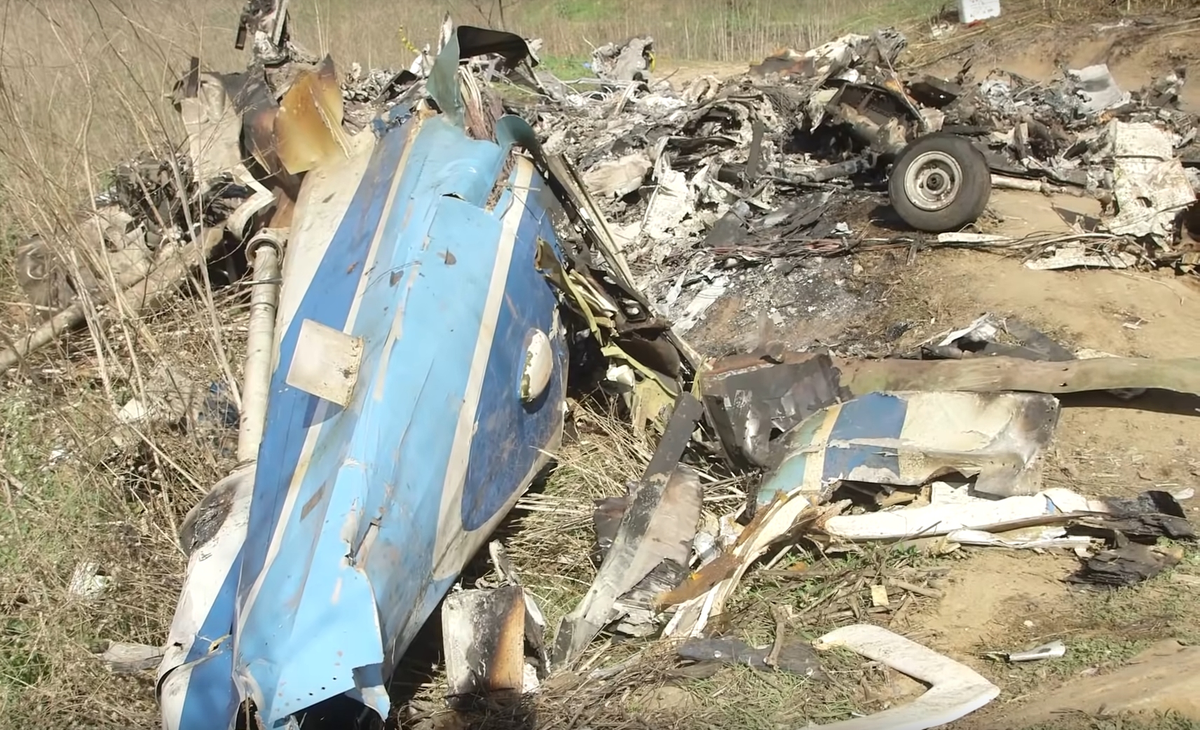
A Sikorsky S-76B helicopter, registered N72EX, impacted hilly terrain in Calabasas, Los Angeles County, California. All nine on board died. Five-time NBA Champion Kobe Bryant was among those on board.
The on-demand flight was operated by Island Express Helicopters Inc. under visual flight rules. The flight departed from John Wayne Airport-Orange County (SNA), Santa Ana, California, about 09:07 and was destined for Camarillo Airport (CMA), Camarillo, California, about 24 miles west of the accident site.
After the helicopter departed from SNA, it flew at altitudes that remained below 1,700 ft mean sea level (msl) and generally between 400 to 600 ft above ground level (agl), and the flight’s progress through controlled airspace en route to CMA was uneventful. Weather conditions reported to the pilot by air traffic controllers during the flight included an overcast ceiling at 1,100 ft agl, visibility of 2.5 miles with haze, and cloud tops at 2,400 ft msl.
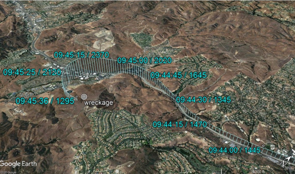
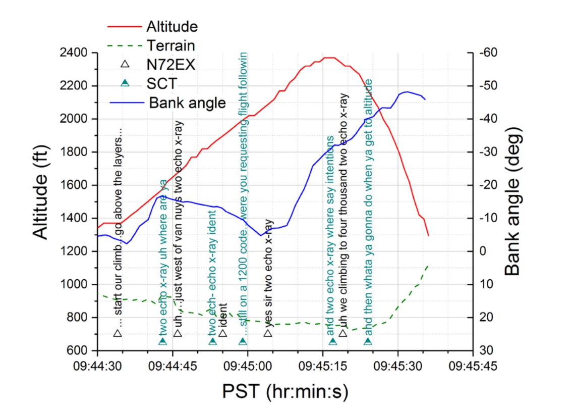
At 09:44:34 (about 2 minutes before the accident), while the helicopter was flying west at an altitude of about 1,370 ft msl (450 ft agl) over US Route 101 and rising terrain, the pilot announced to an air traffic control facility that he was initiating a climb to get the helicopter "above the [cloud] layers," and the helicopter immediately began climbing at a rate of about 1,500 ft per minute. About the same time, the helicopter began a gradual left turn, and its flight path generally continued to follow US 101 below. About 36 seconds later and while still climbing, the helicopter began to turn more tightly to the left, and its flight path diverged from its overflight of US 101.
The helicopter reached an altitude of about 2,370 ft msl (about 1,600 ft agl) at 09:45:15, then it began to descend rapidly in a left turn to the ground. At 09:45:17 (while the helicopter was descending), the air traffic controller asked the pilot to "say intentions," and the pilot replied that the flight was climbing to 4,000 ft msl. A witness near the accident site first heard the helicopter then saw it emerge from the bottom of the cloud layer in a left-banked descent about 1 or 2 seconds before impact.
Probable Cause:
The National Transportation Safety Board determines that the probable cause of this accident was the pilot’s decision to continue flight under visual flight rules into instrument meteorological conditions, which resulted in the pilot’s spatial disorientation and loss of control.
Contributing to the accident was the pilot’s likely self-induced pressure and the pilot’s plan continuation bias, which adversely affected his decision-making, and Island Express Helicopters Inc.’s inadequate review and oversight of its safety management processes.
Accident investigation:
 |
|
Sources:
https://flightaware.com/live/flight/N72EX/history/20200126/1708Z
NTSB DCA20MA059
Location
Images:
Source: NTSB
NTSB
NTSB
Revision history:
| Date/time | Contributor | Updates |
|---|---|---|
| 26-Jan-2020 19:04 | Geno | Added |
| 26-Jan-2020 19:42 | Captain Adam | Updated [Total fatalities, Total occupants, Other fatalities, Source, Embed code, Plane category] |
| 26-Jan-2020 19:53 | Aerossurance | Updated [Embed code, Narrative] |
| 26-Jan-2020 19:53 | Captain Adam | Updated [Aircraft type, Damage, Narrative] |
| 26-Jan-2020 19:58 | Anon. | Updated [Aircraft type, Registration, Cn, Operator, Source, Embed code] |
| 26-Jan-2020 19:59 | harro | Updated [Operator, Source] |
| 26-Jan-2020 20:01 | Iceman 29 | Updated [Operator, Source, Embed code, Photo] |
| 26-Jan-2020 20:01 | Iceman 29 | Updated [Photo] |
| 26-Jan-2020 20:02 | harro | Updated [Operator, Embed code] |
| 26-Jan-2020 20:06 | Iceman 29 | Updated [Time, Operator, Source, Damage] |
| 26-Jan-2020 20:14 | Iceman 29 | Updated [Embed code] |
| 26-Jan-2020 20:14 | harro | Updated [Phase, Nature, Departure airport, Embed code, Narrative, Photo] |
| 26-Jan-2020 20:17 | Iceman 29 | Updated [Embed code] |
| 26-Jan-2020 20:28 | Iceman 29 | Updated [Embed code] |
| 26-Jan-2020 20:42 | Iceman 29 | Updated [Embed code] |
| 26-Jan-2020 20:57 | harro | Updated [Nature, Embed code, Narrative] |
| 26-Jan-2020 21:12 | Iceman 29 | Updated [Embed code] |
| 26-Jan-2020 21:28 | Iceman 29 | Updated [Embed code] |
| 26-Jan-2020 23:40 | Captain Adam | Updated [Total fatalities, Total occupants, Source, Embed code, Narrative] |
| 27-Jan-2020 00:46 | Iceman 29 | Updated [Embed code] |
| 27-Jan-2020 00:56 | Iceman 29 | Updated [Embed code] |
| 27-Jan-2020 02:33 | RobertMB | Updated [Location, Nature, Destination airport, Source, Narrative] |
| 27-Jan-2020 06:56 | Xavier Corday | Updated [Source] |
| 27-Jan-2020 08:08 | Iceman 29 | Updated [Embed code] |
| 27-Jan-2020 11:05 | Iceman 29 | Updated [Embed code] |
| 27-Jan-2020 11:23 | Aerossurance | Updated [Location, Embed code, Narrative] |
| 27-Jan-2020 18:54 | bovine | Updated [Source] |
| 28-Jan-2020 09:06 | Obaid | Updated [Destination airport] |
| 29-Jan-2020 20:13 | Iceman 29 | Updated [Source, Embed code] |
| 29-Jan-2020 20:18 | Iceman 29 | Updated [Embed code] |
| 30-Jan-2020 13:20 | Xavier Corday | Updated [Source] |
| 31-Jan-2020 18:46 | Anon. | Updated [Photo] |
| 08-Feb-2020 08:27 | Anon. | Updated [Source] |
| 08-Feb-2020 08:33 | harro | Updated [Destination airport, Embed code, Narrative] |
| 20-Apr-2020 15:07 | Anon. | Updated [Embed code] |
| 31-Aug-2020 18:55 | airplanecrazy | Updated [Embed code] |
| 07-Feb-2021 09:51 | Anon. | Updated [Source] |
| 10-Feb-2021 10:58 | Iceman 29 | Updated [Source] |
| 11-Feb-2021 22:01 | Iceman 29 | Updated [Source, Embed code, Narrative] |
| 11-Feb-2021 22:02 | Iceman 29 | Updated [Source, Embed code] |
| 13-Feb-2021 17:38 | Aerossurance | Updated [Embed code, Narrative] |
| 14-Feb-2021 20:17 | harro | Updated [Source, Embed code, Narrative, Category] |
| 14-Feb-2021 20:25 | harro | Updated [Embed code, Photo] |
| 14-Feb-2021 20:27 | harro | Updated [Embed code, Photo] |
| 14-Feb-2021 20:29 | harro | Updated [Embed code, Photo] |
| 14-Feb-2021 20:30 | harro | Updated [Time, Embed code] |
| 26-Mar-2021 15:35 | ASN Update Bot | Updated [Time, Other fatalities, Nature, Source, Embed code, Narrative, Category, Accident report] |
| 26-Mar-2021 16:23 | harro | Updated [Nature, Source, Narrative, Accident report] |
| 17-Nov-2023 18:23 | harro | Updated [Other fatalities] |
Corrections or additions? ... Edit this accident description
The Aviation Safety Network is an exclusive service provided by:
Quick Links:
| ASN Home | Send Correction / Feedback |
| FSF Home | Disclaimer | Copyright |
| Contact Us | Privacy Policy |
| Press / Media |
 ©2024 Flight Safety Foundation