

ASN Wikibase Occurrence # 232807
This information is added by users of ASN. Neither ASN nor the Flight Safety Foundation are responsible for the completeness or correctness of this information.
If you feel this information is incomplete or incorrect, you can submit corrected information.
| Date: | Thursday 6 February 2020 |
| Time: | 11:10 |
| Type: |  Piper PA-32R-300 Cherokee Lance |
| Owner/operator: | Yute Commuter Service |
| Registration: | N7632C |
| MSN: | 32R-7680054 |
| Year of manufacture: | 1975 |
| Total airframe hrs: | 7766 hours |
| Engine model: | Lycoming IO-540-K1G5D |
| Fatalities: | Fatalities: 5 / Occupants: 5 |
| Aircraft damage: | Destroyed |
| Category: | Accident |
| Location: | near Tuntutuliak, AK -
 United States of America United States of America
|
| Phase: | En route |
| Nature: | Passenger |
| Departure airport: | Bethel Airport, AK (BET/PABE) |
| Kipnuk Airport, AK (KPN/PAKI) | |
| Investigating agency: | NTSB |
| Confidence Rating: |
On February 6, 2020, about 1110 Alaska standard time, a Piper PA-32R-300 airplane, N7632C, was substantially damaged when it was involved in an accident near Tuntutuliak, Alaska. The commercial pilot and four passengers were fatally injured. The airplane was operated by Paklook Air Inc., doing business as Yute Commuter Service, as a Title 14 Code of Federal Regulations Part 135 scheduled passenger flight.
The commercial pilot departed under a special visual flight rules (VFR) clearance with four passengers on a VFR scheduled passenger flight. The airplane was reported overdue about an hour later when it had not reached its destination and was subsequently located about 35 nautical miles from the departure airport. There was no radar or other flight tracking information available for the accident flight, and the airplane’s flight track before the accident could not be determined; however, the wreckage was located along a direct course between the departure and destination and on a heading consistent with the intended direction of flight. The airplane was highly fragmented and the wreckage was distributed along a nearly 400-ft-long debris path. Examination of the airplane and engine did not reveal any evidence of mechanical malfunctions or anomalies that would have precluded normal operation.
The weather about the time of departure included 1 ¼ miles visibility, a runway visual range of 2,200 ft to better than 6,000 ft, unknown precipitation and mist, and an overcast ceiling at 600 ft above ground level (agl). The observation closest to the accident time indicated 3 miles visibility, mist, and an overcast ceiling at 500 ft agl. Between the departure time and the accident time, instrument flight rules or low instrument flight rules conditions prevailed at the departure airport. In the hour after the accident, both the departure and intended destination airports reported low instrument flight conditions with visibility as low as ½ statute mile in light snow, mist, and freezing fog, and cloud ceilings as low as 400 ft agl.
An atmospheric sounding depicted a stable atmosphere with cloud bases around 700 ft agl. A frontal inversion was collocated between the lifted condensation level, around 700 ft agl, and 3,000 ft mean sea level. The wind profile suggested the potential for low-level turbulence based on the low-level wind maximum and the strong vertical shear near the inversion and a 77% probability of moderate to severe turbulence at 700 ft due to the strong vertical wind shear. It is also likely that light to moderate rime icing conditions were present in clouds and precipitation.
The pilot had been recently hired by the operator and had completed initial operating experience requirements the week before the accident. Interviews with the director of operations, general manager, and the flight follower who assigned the accident flight indicated that company policy required a minimum of 2 statute miles visibility and a cloud ceiling of at least 500 ft agl. Pilots were required to complete a flight risk assessment form before each flight, which was to be approved or disapproved by the director of operations or their delegate before the flight was released. No risk assessment form was located for the accident flight, and who approved the flight to depart could not be determined.
Based on the available information, a lack of operational control permitted the pilot to depart into weather conditions that were below the minimums specified by company operating procedures. It is likely that, while en route, the pilot encountered adverse weather including low visibility, precipitation, and turbulence. Such conditions, in addition to the snow-covered terrain and overcast and/or low visibility likely present at the time of the accident, would have been conducive to flat light or white-out conditions. In these conditions pilots can experience illusions that can lead to unrecognized descents because of the difficulty discriminating between terrain and sky to identify a visible horizon. With the low ceilings likely en route, the pilot would have been flying at altitudes that would have precluded recognition and recovery from an inadvertent descent.
The direction, distribution and fragmentation of the wreckage was consistent with a controlled flight into terrain event.
Probable Cause: The pilot's continued visual flight rules flight into reduced visibility, including likely flat light and/or white out conditions, which resulted in a controlled flight into terrain. Contributing to the accident were the operator’s inadequate operational control procedures, which permitted the pilot to depart into conditions that were below the minimums specified by their operating procedures.
Accident investigation:
 |
|
Sources:
https://www.kyuk.org/post/plane-carrying-five-people-crashes-near-tuntutuliak
https://www.adn.com/alaska-news/aviation/2020/02/07/rescuers-responding-to-plane-crash-near-bethel/
https://www.ktuu.com/content/news/Troopers-investigate-plane-crash-near-Tuntutuliak-567641841.html
https://yutebethel.com
Location
Images:
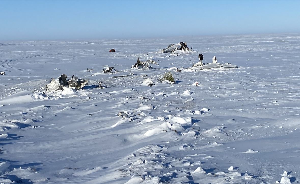
Photo: NTSB
Revision history:
| Date/time | Contributor | Updates |
|---|---|---|
| 06-Feb-2020 23:38 | Captain Adam | Added |
| 07-Feb-2020 03:03 | RobertMB | Updated [Time, Aircraft type, Other fatalities, Location, Phase, Nature, Source, Narrative] |
| 07-Feb-2020 03:35 | Geno | Updated [Time, Operator, Total fatalities, Nature, Departure airport, Destination airport, Source] |
| 07-Feb-2020 07:20 | harro | Updated [Aircraft type] |
| 07-Feb-2020 07:21 | harro | Updated [Operator, Source] |
| 07-Feb-2020 08:33 | RobertMB | Updated [Aircraft type, Damage, Narrative] |
| 07-Feb-2020 15:03 | harro | Updated [Registration, Cn, Source] |
| 07-Feb-2020 16:37 | Aerossurance | Updated [Source, Narrative] |
| 10-Feb-2020 02:40 | Captain Adam | Updated [Location, Narrative] |
| 26-Feb-2020 18:05 | harro | Updated [Time, Source, Narrative, Photo] |
| 15-Jun-2021 19:16 | aaronwk | Updated [Time, Location, Source, Narrative] |
| 08-Sep-2022 10:49 | Captain Adam | Updated [Location, Source, Narrative, Accident report] |
Corrections or additions? ... Edit this accident description
The Aviation Safety Network is an exclusive service provided by:
Quick Links:
| ASN Home | Send Correction / Feedback |
| FSF Home | Disclaimer | Copyright |
| Contact Us | Privacy Policy |
| Press / Media |
 ©2024 Flight Safety Foundation