

ASN Wikibase Occurrence # 233544
This information is added by users of ASN. Neither ASN nor the Flight Safety Foundation are responsible for the completeness or correctness of this information.
If you feel this information is incomplete or incorrect, you can submit corrected information.
| Date: | Tuesday 3 March 2020 |
| Time: | 16:34 |
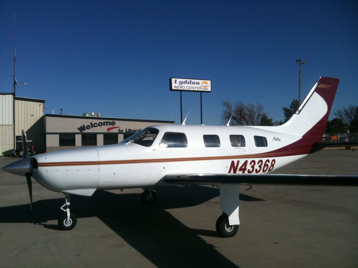
| Type: |  Piper PA-46-310P Malibu |
| Owner/operator: | Triple 4 Aviation LLC |
| Registration: | N43368 |
| MSN: | 46-8408028 |
| Year of manufacture: | 1984 |
| Engine model: | Continental TSIO-520 SER |
| Fatalities: | Fatalities: 3 / Occupants: 3 |
| Aircraft damage: | Destroyed |
| Category: | Accident |
| Location: | Bishop, GA -
 United States of America United States of America
|
| Phase: | En route |
| Nature: | Private |
| Departure airport: | Columbia Metropolitan Airport, SC (CAE/KCAE) |
| Tuscaloosa Regional Airport, AL (TCL/KTCL) | |
| Investigating agency: | NTSB |
| Confidence Rating: |
On March 3, 2020, about 1634 eastern standard time, a Piper PA-46-310P, N43368, was destroyed when it was involved in an accident near Bishop, Georgia. The private pilot and two passengers were fatally injured. The airplane was operated as a Title 14 Code of Federal Regulations Part 91 personal flight.
The pilot departed on an instrument flight rules cross-country flight with three passengers. While enroute at a cruise altitude about 6,000 ft mean sea level (msl), the pilot discussed routing and weather avoidance with the controller. The controller advised the pilot there was a gap in the line of weather showing light precipitation, and that the pilot could pass through it and then proceed on course.
The controller assigned the pilot a heading, which the pilot initially acknowledged, but shortly thereafter, he advised the controller that the airplane was pointed directly at a convective cell. The controller explained that the heading would keep the pilot out of the heavy precipitation and that he would then turn the airplane through an area of light precipitation. The pilot responded, saying that the area seemed to be closing in fast, the controller acknowledged and advised the pilot if he did not want to accept that routing, he could be rerouted. The pilot elected to turn toward a gap that he saw and felt he could fly straight through it. The controller acknowledged and advised the pilot that course would take him through moderate precipitation starting in about one mile extending for about four miles; the pilot acknowledged.
Radar information indicated that the airplane entered an area of heavy to very heavy precipitation, likely a rain shower updraft, while in instrument meteorological conditions, then entered a right, descending spiral and broke up in flight.
Examination of the wreckage revealed no evidence of a preaccident malfunction or failure that would have prevented normal operation.
The airplane was equipped with the capability to display weather radar "mosaic" imagery created from Next Generation Radar (NEXRAD) data and it is likely that the pilot was using this information to navigate around precipitation when the airplane encountered a rain shower updraft with likely severe turbulence. Due to latencies inherent in processes used to detect and deliver the NEXRAD data from the ground site, as well as the frequency of the mosaic-creation process used by the service provider, NEXRAD data can age significantly by the time the mosaic image is created. The pilot elected to navigate the hazardous weather along his route of flight based on the data displayed to him instead of the routing suggested by the controller, which resulted in the penetration of a rain shower updraft, a loss of airplane control, and a subsequent inflight breakup.
Probable Cause: The pilot’s encounter with a rain shower updraft and severe turbulence, which resulted in a loss of airplane control and an inflight breakup. Contributing to the accident was the pilot’s reliance on outdated weather information on his in-cockpit weather display.
Accident investigation:
 |
|
Sources:
https://app.ntsb.gov/pdfgenerator/ReportGeneratorFile.ashx?EventID=20200303X93345&AKey=1&RType=HTML&IType=FA
https://www.al.com/news/tuscaloosa/2020/03/oconee-county-plane-crash-multiple-fatalities-as-alabama-bound-plane-crashes-in-georgia.html
https://www.usnews.com/news/best-states/south-carolina/articles/2020-03-03/single-engine-plane-crashes-in-georgias-oconee-county
https://www.ajc.com/news/crime--law/breaking-plane-crash-reported-oconee-county/dkKThsCoJBGUegBqyBSptK/
https://www.wsbtv.com/news/local/plane-crash-shuts-down-several-roads-oconee-county/MDY3Z47NEZHPBCBXRKFIAACUNE/
NTSB
https://registry.faa.gov/aircraftinquiry/NNum_Results.aspx?NNumbertxt=43368
https://flightaware.com/live/flight/N43368/history/20200303/1830Z/KCAE/KTCL
https://photos-e1.flightcdn.com/photos/retriever/400d20c113cc19950a41a28bafabcf84cab897be (photo)
History of this aircraft
Other occurrences involving this aircraft
| 20 February 2010 | N43368 | Big Sky Inc | 0 | Nashville, Tennessee | |
min |
| Inflight smoke | ||||||
Location
Images:
© Rocky Ormiston, with authorization.
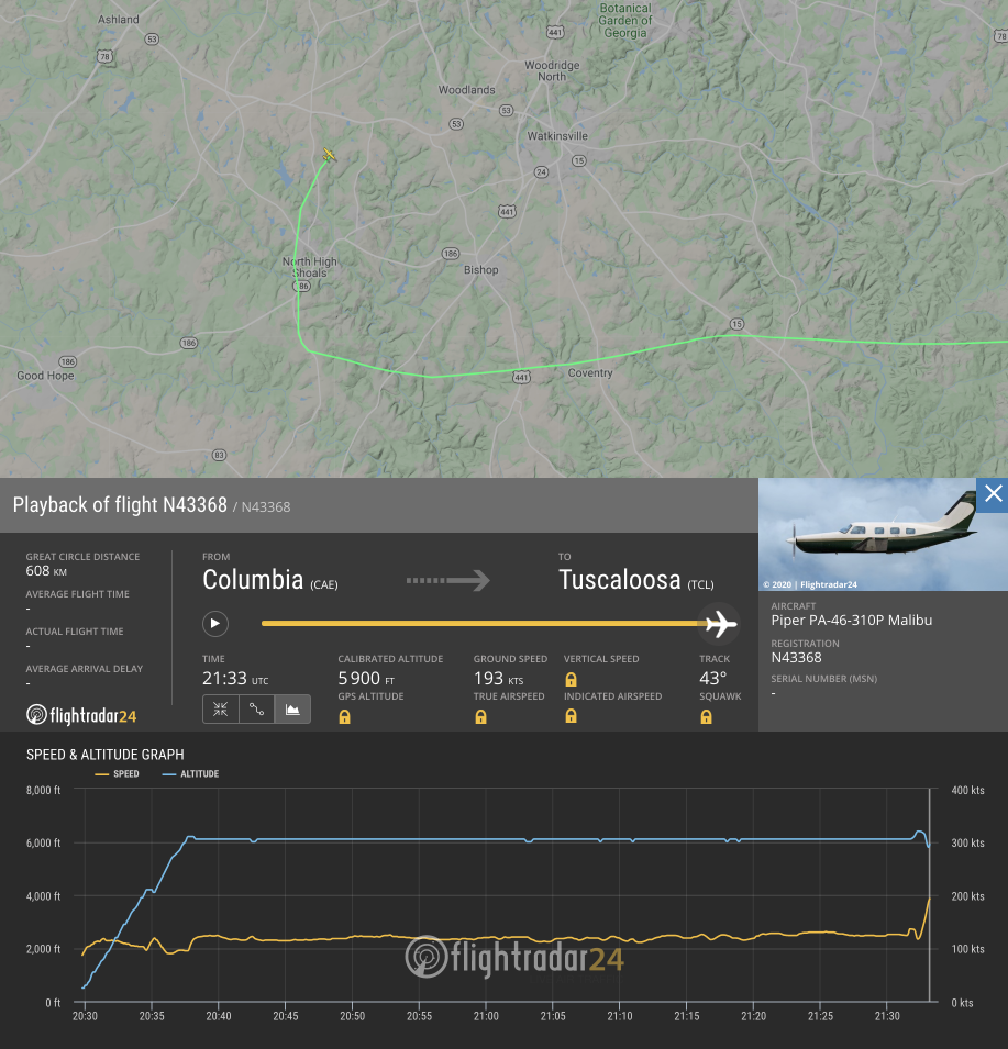
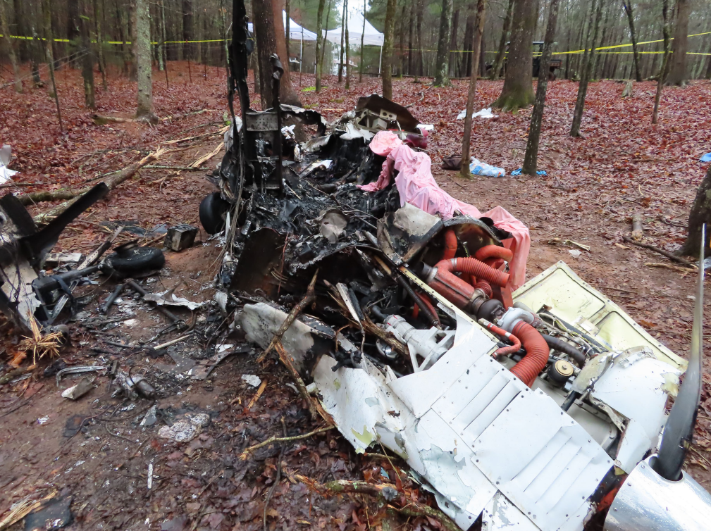
Photo: NTSB
Media:
Authorities say three people are dead after this fiery plane crash in Oconee County. I'll have the latest on the investigation tonight at 10 and 11 @FOX5Atlanta pic.twitter.com/c83AVt6eCG
— Janice Yu (@JaniceYuNews) March 4, 2020
Revision history:
| Date/time | Contributor | Updates |
|---|---|---|
| 04-Mar-2020 00:04 | Geno | Added |
| 04-Mar-2020 00:08 | Geno | Updated [Aircraft type, Source, Damage, Narrative] |
| 04-Mar-2020 05:05 | RobertMB | Updated [Time, Registration, Total fatalities, Total occupants, Location, Source, Damage, Narrative] |
| 04-Mar-2020 07:01 | Iceman 29 | Updated [Source, Embed code] |
| 04-Mar-2020 21:31 | Iceman 29 | Updated [Embed code, Photo] |
| 04-Mar-2020 22:49 | Captain Adam | Updated [Location, Nature, Narrative] |
| 06-Mar-2020 14:01 | Iceman 29 | Updated [Photo] |
| 02-Apr-2020 14:24 | Captain Adam | Updated [Narrative] |
| 04-Apr-2020 17:38 | harro | Updated [Source, Narrative] |
Corrections or additions? ... Edit this accident description
The Aviation Safety Network is an exclusive service provided by:
Quick Links:
| ASN Home | Send Correction / Feedback |
| FSF Home | Disclaimer | Copyright |
| Contact Us | Privacy Policy |
| Press / Media |
 ©2024 Flight Safety Foundation