ASN Wikibase Occurrence # 236714
This information is added by users of ASN. Neither ASN nor the Flight Safety Foundation are responsible for the completeness or correctness of this information.
If you feel this information is incomplete or incorrect, you can submit corrected information.
| Date: | Friday 5 June 2020 |
| Time: | 08:01 |
| Type: |  Cessna 175 Skylark |
| Owner/operator: | Private |
| Registration: | N9217B |
| MSN: | 55017 |
| Year of manufacture: | 1958 |
| Engine model: | Continental GO-300-A |
| Fatalities: | Fatalities: 3 / Occupants: 3 |
| Aircraft damage: | Destroyed |
| Category: | Accident |
| Location: | Redlands, San Bernardino County, CA -
 United States of America United States of America
|
| Phase: | En route |
| Nature: | Private |
| Departure airport: | Big Bear Airport, CA (L35) |
| Redlands Municipal Airport, CA (KREI) | |
| Investigating agency: | NTSB |
| Confidence Rating: |
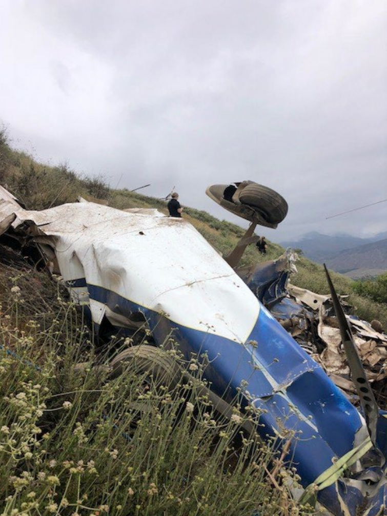
The noncertificated pilot was conducting a cross-country flight during daytime visual flight rules flight conditions. Recorded automatic dependent surveillance-broadcast (ADS-B) data showed that as the airplane was on a southerly heading, nearing the destination airport, it made a left 270° turn at an altitude of 5,125 ft msl. About 46 second later, the airplane completed the turn, and was established on a west-northwesterly heading, at an altitude of 5,275 ft msl. About 1 minute later, the airplane made a left turn to a southwesterly heading, at an altitude of 3,975 ft msl and continued to descend until ADS-B contact was lost 34 seconds later at an altitude of 2,775 ft, and about 436 ft northeast of the accident site. The accident site was in hilly terrain, about 3.47 miles southeast of the intended destination. There were no known witnesses to the accident sequence.
A postaccident examination of the recovered wreckage revealed no evidence of any preexisting mechanical malfunction that would have precluded normal operation.
Weather data for the area around the accident site depicted favorable conditions for overcast clouds and restricted visibility with haze and clouds from the surface with tops near 4,300 ft. In addition, marginal visual meteorological conditions to instrument meteorological conditions (IMC) prevailed during the period, with instrument flight rules (IFR) to low IFR conditions being reported at the two closest airports southwest of the accident site. Due to IMC, the pilot likely did not have visible reference to the horizon during the descent to the destination airport, which resulted in a collision with terrain.
Whether effects from the pilot’s use of lamotrigine or some underlying medical condition contributed to the accident cannot be determined based on the limited available evidence. Some or all of the detected ethanol may have been from sources other than ingestion. It is unlikely that ethanol contributed to the accident.
Probable Cause: The noncertificated pilot’s visual flight rules flight into instrument meteorological conditions and subsequent impact with terrain.
Accident investigation:
 |
|
Sources:
https://losangeles.cbslocal.com/2020/06/05/yucaipa-plane-crash-crafton-hills-cessna/
https://registry.faa.gov/aircraftinquiry/NNum_Results.aspx?NNumbertxt=N9217B
https://flightaware.com/live/flight/N9217B/history/20200605/1446Z
Location
Images:

Photo: NTSB
Revision history:
| Date/time | Contributor | Updates |
|---|---|---|
| 06-Jun-2020 02:51 | Geno | Added |
| 24-Jun-2021 07:26 | aaronwk | Updated [Time, Nature, Departure airport, Destination airport, Source, Narrative] |
| 07-Jun-2022 20:53 | Captain Adam | Updated [Location, Phase, Departure airport, Source, Narrative, Category, Accident report, Photo] |
Corrections or additions? ... Edit this accident description
The Aviation Safety Network is an exclusive service provided by:


 ©2024 Flight Safety Foundation