

ASN Wikibase Occurrence # 237110
This information is added by users of ASN. Neither ASN nor the Flight Safety Foundation are responsible for the completeness or correctness of this information.
If you feel this information is incomplete or incorrect, you can submit corrected information.
| Date: | Thursday 18 June 2020 |
| Time: | 17:00 |
| Type: |  Robinson R66 Turbine |
| Owner/operator: | Kritter Cropdusting Inc |
| Registration: | N4QW |
| MSN: | 0402 |
| Year of manufacture: | 2013 |
| Total airframe hrs: | 496 hours |
| Engine model: | Rolls Royce 250-C300/A1 |
| Fatalities: | Fatalities: 1 / Occupants: 1 |
| Aircraft damage: | Substantial |
| Category: | Accident |
| Location: | near Pikeville, NC -
 United States of America United States of America
|
| Phase: | Manoeuvring (airshow, firefighting, ag.ops.) |
| Nature: | Agricultural |
| Departure airport: | Pikeville, NC |
| Pikeville, NC | |
| Investigating agency: | NTSB |
| Confidence Rating: |
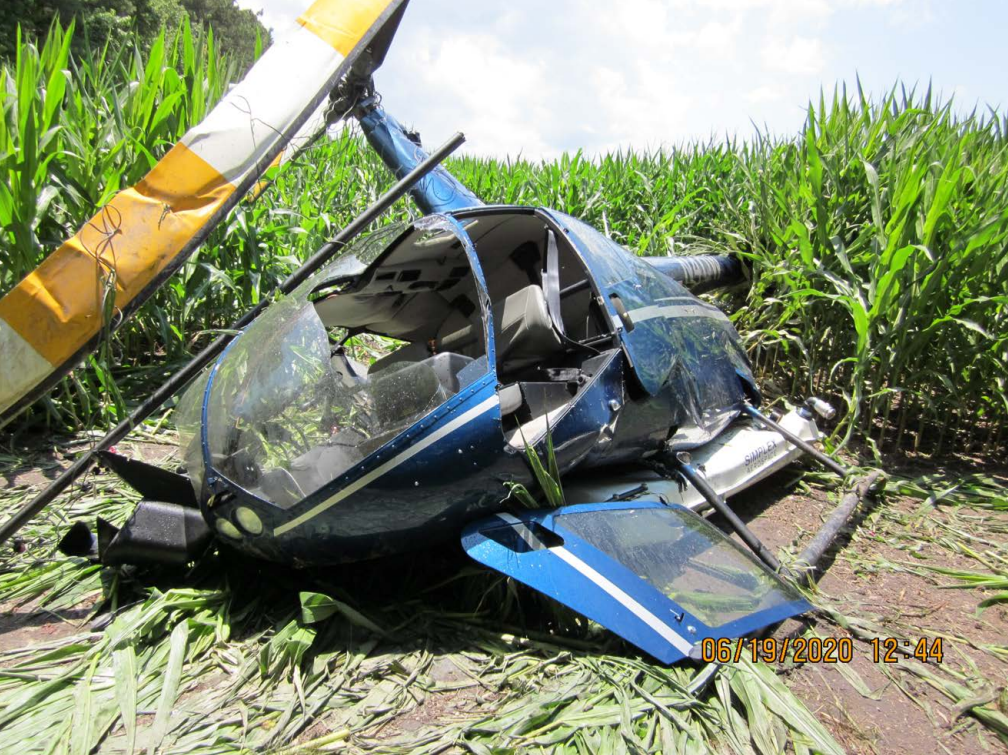
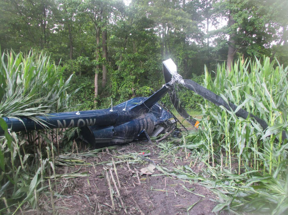
On June 18, 2020, at 1700 eastern daylight time, a Robinson R66 helicopter, N4QW, was substantially damaged when it was involved in an accident near Pikeville, North Carolina. The pilot was fatally injured. The helicopter was being operated as a Title 14 Code of Federal Regulations Part 137 aerial application flight.
The pilot was applying insecticide to a farm field and the accident flight was the first time the pilot had sprayed the field. Once he arrived at the site, 3 hours late, the pilot conducted two circular passes to survey the field, then landed, and the ground crew loaded the insecticide into the hopper. The pilot was not briefed of any hazards to operations prior to the flight by the ground crew or farmer. After takeoff, the pilot started applying the chemicals.
The helicopter was performing the spraying operation and was flying on a northerly heading when it impacted a non-energized wire. The wire was mounted about 30 feet up a 40 ft pole that also contained a hunting stand and stretched about 250 ft across the field from west to east where it connected to a tree bordering the field. The wire had been installed at least 20 years earlier and was installed high enough that a tractor or combine had clearance to move beneath it during harvest.
Clear daylight conditions existed at the time of the accident. The sun was at 39.85° above the horizon at an azimuth of 272.39° and was very close to being directly in line with the wire. It is possible that the sun’s position relative to the wire would have made the 5/16-inch wire more difficult to see as the shadow of the wire and pole would have been nearly directly under the wire rather than offset.
The pilot, unfamiliar with the field, running late, and without the benefit of a detailed discussion with the landowner, relied solely on his brief visual surveillance of the field while operating the helicopter. Although the pilot likely observed the pole and hunting stand during his surveillance, it is likely that he did not see the wire due to its small diameter. Therefore, shortly after initiating the application of the insecticide, the pilot’s failure to see and avoid the wire resulted in the helicopter impacting the wire and the pilot’s subsequent loss of control and impact with terrain.
Probable Cause: The pilot’s failure to see and avoid a small diameter wire during low altitude agricultural spraying operations. Contributing to the accident was the pilot’s insufficient property survey.
Accident investigation:
 |
|
Sources:
https://www.wral.com/pilot-killed-when-helicopter-crashes-in-wayne-county-field/19151000/
https://www.clausonlaw.com/accident-news/2020/06/19/pilot-killed-in-plane-crash-near-daw-pate-road-in-wayne-county/
NTSB
https://flightaware.com/live/flight/N4QW
https://registry.faa.gov/aircraftinquiry/NNum_Results.aspx?NNumbertxt=N4QW
Location
Images:
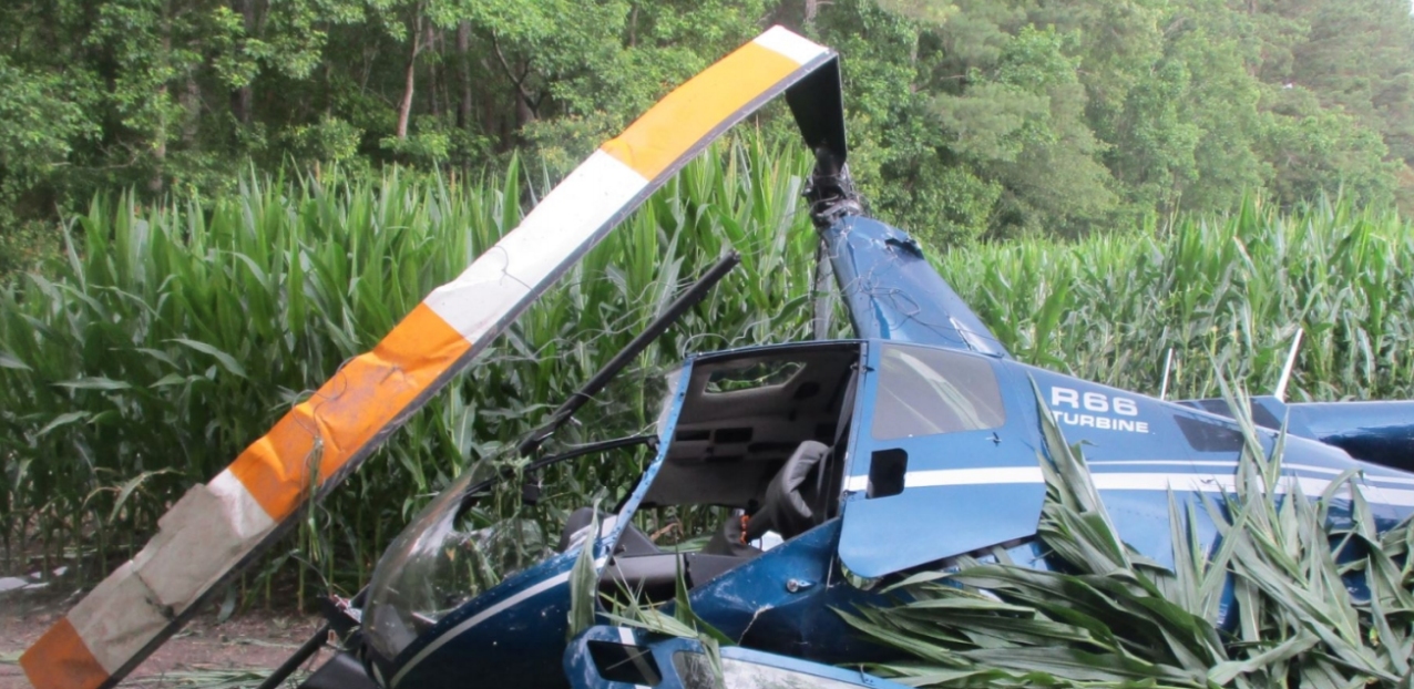
Photo: NTSB
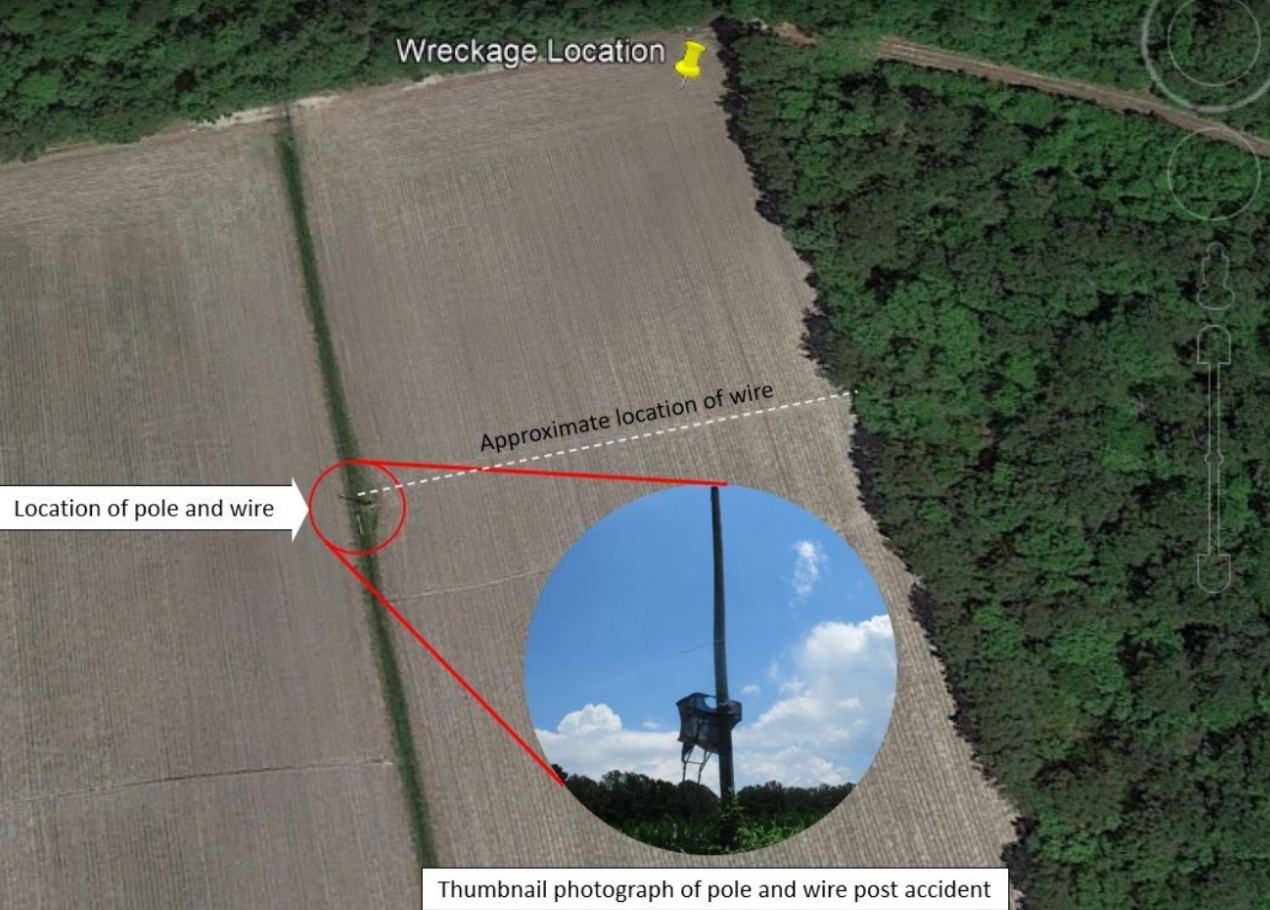
Photo: NTSB
Photos: NTSB
Revision history:
| Date/time | Contributor | Updates |
|---|---|---|
| 18-Jun-2020 23:09 | Geno | Added |
| 18-Jun-2020 23:26 | RobertMB | Updated [Time, Total occupants, Location, Source, Damage, Narrative] |
| 19-Jun-2020 12:32 | Geno | Updated [Source, Narrative] |
| 20-Jun-2020 06:33 | Petropavlovsk | Updated [Damage, Narrative] |
| 20-Feb-2021 15:24 | Anon. | Updated [Narrative] |
| 03-Mar-2021 10:40 | harro | Updated [Location, Departure airport, Destination airport, Source, Damage, Narrative, Category, Photo] |
| 03-Mar-2021 10:41 | harro | Updated [Source, Photo] |
| 07-May-2021 17:49 | rudy | Updated [Category] |
| 08-Sep-2022 11:01 | Captain Adam | Updated [Time, Source, Narrative, Category, Accident report, Photo] |
| 08-Sep-2022 11:02 | Captain Adam | Updated [Photo] |
Corrections or additions? ... Edit this accident description
The Aviation Safety Network is an exclusive service provided by:
Quick Links:
| ASN Home | Send Correction / Feedback |
| FSF Home | Disclaimer | Copyright |
| Contact Us | Privacy Policy |
| Press / Media |
 ©2024 Flight Safety Foundation