

ASN Wikibase Occurrence # 240641
This information is added by users of ASN. Neither ASN nor the Flight Safety Foundation are responsible for the completeness or correctness of this information.
If you feel this information is incomplete or incorrect, you can submit corrected information.
| Date: | Saturday 29 August 2020 |
| Time: | 01:23 |
| Type: |  Cirrus SR22 GTS X G3 |
| Owner/operator: | Private |
| Registration: | N607SR |
| MSN: | 2532 |
| Year of manufacture: | 2007 |
| Total airframe hrs: | 2237 hours |
| Engine model: | Teledyne Continental IO-550-N |
| Fatalities: | Fatalities: 1 / Occupants: 1 |
| Aircraft damage: | Destroyed |
| Category: | Accident |
| Location: | near Lawrenceville–Vincennes International Airport (LWV/KLWV), IL -
 United States of America United States of America
|
| Phase: | Approach |
| Nature: | Private |
| Departure airport: | Sullivan County Airport, IN (SIV/KSIV) |
| Lawrenceville-Vincennes International Airport, IL (LWV/KLWV) | |
| Investigating agency: | NTSB |
| Confidence Rating: |
The instrument-rated pilot was conducting a night instrument approach to an airport 22 nautical miles south from his departure airport in instrument meteorological conditions. Shortly after departure, the pilot established communications with air traffic control and was instructed to maintain 2,600 ft and fly direct to the initial approach fix for the GPS approach. Air traffic data revealed the airplane flew past the initial approach fix before turning south then remained west of the final approach course while inbound on the approach. For the last 2 minutes of the flight, the airplane descended from 2,200 ft to 600 ft at an average rate of 800 ft per minute and an average groundspeed of 116 knots. The airplane impacted trees and terrain about 1.5 miles north of the runway threshold at the destination airport and was destroyed by impact and postimpact fire.
Examination of the accident site revealed multiple tree impacts north of where the main wreckage came to rest. The impact signatures observed on the trees and the wreckage fragmentation pattern were consistent with the airplane having a slight nose-down, near-level attitude with high forward velocity at impact. Postaccident examination of the airframe and engine revealed no evidence of any preimpact mechanical malfunctions or failures that would have precluded normal operation.
Toxicological testing detected carboxyhemoglobin in the pilot’s blood at 11%; however, soot was detected in the pilot’s throat during autopsy, indicating the source of the carboxyhemoglobin was likely from the postimpact fire.
The pilot had purchased the airplane about 2 months before the accident and had completed the Cirrus Embark training program, which included ground and flight instruction. The pilot had logged about 46 flight hours, including 9.1 night hours, 1.8 hours in actual instrument conditions, and 7 instrument approaches prior to the day of the accident. The day before the accident, the airplane’s GPS/NAV/COM system was changed from a Garmin system to a new Avidyne system. Based on available information, the accident approach was the pilot’s second instrument approach flown with the new system.
Based on the wreckage distribution and the low visibility present at the time of the accident, it is likely that the airplane impacted trees and terrain as a result of the pilot’s controlled flight into terrain due to the improper execution of the instrument approach. The pilot’s lack of familiarity with a new avionics system likely contributed to his inability to maintain approach parameters in night instrument meteorological conditions.
Probable Cause: The pilot’s controlled flight into terrain as a result of his failure to properly execute an instrument approach and maintain clearance from trees in night instrument meteorological conditions. Contributing to the accident was the pilot’s unfamiliarity with a newly installed avionics system.
Accident investigation:
 |
|
Sources:
https://wibqam.com/2020/08/29/plane-crash-investigation-underway-in-lawrence-county-il/
NTSB
https://flightaware.com/live/flight/N607SR/history/20200829/0605Z/KSIV/KLWV
https://registry.faa.gov/AircraftInquiry/NNum_results.aspx?NNumbertxt=607SR
https://skyvector.com/files/tpp/2106/pdf/00229R18.PDF [GPS 18 instrument approach]
https://cdn.jetphotos.com/full/5/23231_1510912792.jpg (photo)
Location
Images:
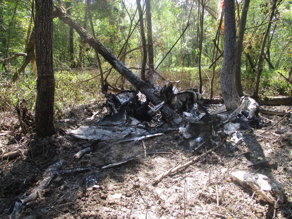
Photo: NTSB
Media:
The NTSB is investigating Saturday’s crash in Lawrenceville, IL involving a Cirrus SR22. The NTSB is not traveling to the scene of the crash at this time.
— NTSB_Newsroom (@NTSB_Newsroom) August 29, 2020
Revision history:
| Date/time | Contributor | Updates |
|---|---|---|
| 29-Aug-2020 16:50 | Captain Adam | Added |
| 29-Aug-2020 17:49 | RobertMB | Updated [Time, Aircraft type, Registration, Cn, Operator, Total fatalities, Total occupants, Other fatalities, Phase, Nature, Departure airport, Destination airport, Source, Embed code, Damage, Narrative] |
| 30-Aug-2020 01:09 | Captain Adam | Updated [Operator, Source, Narrative] |
| 31-Aug-2020 15:34 | RobertMB | Updated [Source, Narrative] |
| 08-Sep-2020 12:43 | ASN Update Bot | Updated [Time, Operator, Departure airport, Destination airport, Source, Narrative] |
| 28-Jun-2021 13:12 | aaronwk | Updated [Departure airport, Destination airport, Source, Narrative, Category] |
| 07-Jun-2022 21:11 | Captain Adam | Updated [Source, Narrative, Accident report, Photo] |
Corrections or additions? ... Edit this accident description
The Aviation Safety Network is an exclusive service provided by:
Quick Links:
| ASN Home | Send Correction / Feedback |
| FSF Home | Disclaimer | Copyright |
| Contact Us | Privacy Policy |
| Press / Media |
 ©2024 Flight Safety Foundation