

ASN Wikibase Occurrence # 240868
This information is added by users of ASN. Neither ASN nor the Flight Safety Foundation are responsible for the completeness or correctness of this information.
If you feel this information is incomplete or incorrect, you can submit corrected information.
| Date: | Monday 31 August 2020 |
| Time: | 19:00 |
| Type: |  Piper PA-20-135 Pacer |
| Owner/operator: | Private |
| Registration: | N7323K |
| MSN: | 20-268 |
| Year of manufacture: | 1950 |
| Total airframe hrs: | 1945 hours |
| Engine model: | Lycoming O-290-D |
| Fatalities: | Fatalities: 1 / Occupants: 1 |
| Aircraft damage: | Destroyed |
| Category: | Accident |
| Location: | Shenandoah National Park, near Luray, VA -
 United States of America United States of America
|
| Phase: | En route |
| Nature: | Private |
| Departure airport: | Indian Head Airport, MD (2W5) |
| Petersburg Airport, WV (W99) | |
| Investigating agency: | NTSB |
| Confidence Rating: |
Throughout the afternoon of the accident flight, the noninstrument-rated pilot had delayed his departure due to poor weather along his intended route, and despite any meaningful change in the weather conditions along the route or at the presumed destination, he decided to depart. Data obtained from the pilot’s electronic flight bag (EFB) application, in addition to a course change in the airplane’s recorded flight track, indicated that, about 20 minutes into the flight, the pilot initiated a diversion to a new airport. Although the new airport was reporting visual flight rules (VFR) conditions, instrument flight rules (IFR) conditions and mountain obscuration were present along the route of flight. Each of these conditions were forecast before the pilot’s departure. Review of the weather conditions along the route indicated that the pilot passed airports with VFR conditions but chose to continue into an area of deteriorating visibility and cloud ceilings.
As the pilot approached rising terrain toward the new destination, the flight track deviated to the left and right, followed by a left 360° level turn. The 360° turn was completed in about 1 minute. The airplane then continued in a second left turn, during which its altitude began to rapidly decrease, and the turn developed into a descending spiral. The final position was recorded with the airplane about 500 ft above terrain about ¼ mile east of the accident site. The airplane’s flight track was consistent with the known effects of spatial disorientation and a subsequent loss of control and impact with terrain.
The wreckage was located 40 hours after the accident in heavily wooded terrain at the bottom of a steep ravine. The fragmentation of the wreckage indicated that the airplane impacted terrain in a high speed, uncontrolled descent. A postaccident examination of the airplane did not reveal any evidence of mechanical malfunctions. The pilot did not file a flight plan, obtain an official weather briefing, nor was he receiving air traffic control services at the time of the accident.
It is likely that the pilot encountered instrument meteorological conditions (IMC), which included rain, clouds, and low visibility, as he neared the rising terrain and continued flight into IMC. The pilot did not possess the qualifications to operate in IMC, and the airplane was not equipped for IFR flight. The investigation found evidence that the pilot likely relied extensively on an EFB application for GPS navigation. Photos from the pilot’s past flights showed that he had mounted the EFB in the forward windscreen area and data retrieval from the EFB application found that the pilot was actively utilizing the EFB while enroute in the accident flight. It is possible that the pilot was utilizing the application’s attitude indicator/synthetic vision feature as he entered IMC. The EFB application pilot’s guide stated that the attitude indicator/synthetic vision feature may only be used for informational purposes and cannot be used as a primary reference.
Probable Cause: The noninstrument-rated pilot’s continued visual flight into instrument meteorological conditions, which resulted in spatial disorientation, a loss of control, and collision with terrain.
Accident investigation:
 |
|
Sources:
https://www.wsls.com/news/local/2020/09/02/small-plane-crashes-in-shenandoah-national-park/
https://www.whsv.com/video/2020/09/02/breaking-news-plane-crash-reported-shenandoah-national-park/
https://www.insidenova.com/headlines/updated-shenandoah-plane-crash-went-undiscovered-for-two-days/article_907e3978-ee0a-11ea-b5d2-838c4f57d45e.html
NTSB
https://flightaware.com/live/flight/N7323K
https://photos-e1.flightcdn.com/photos/retriever/f2418ae1964b483617800da88ba6047b1eae063b (photo)
Location
Images:
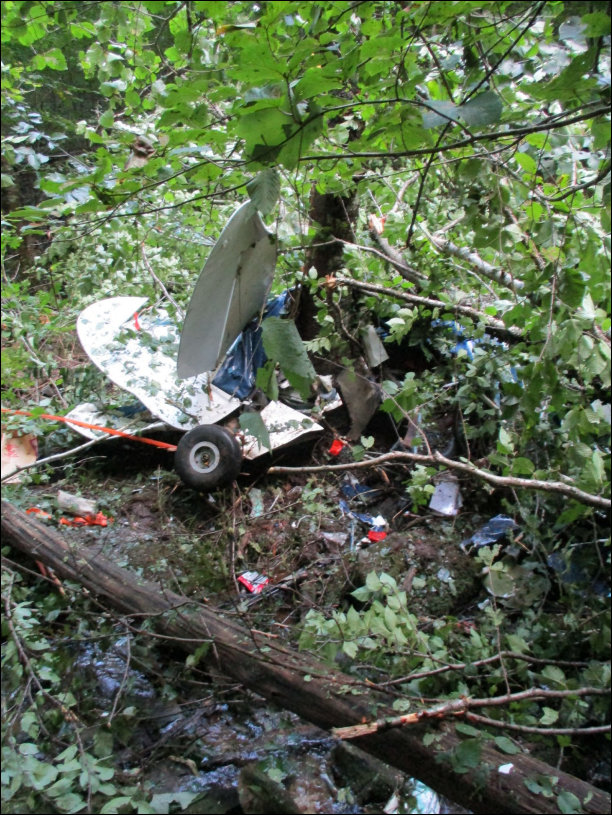
Photo: NTSB
Revision history:
| Date/time | Contributor | Updates |
|---|---|---|
| 03-Sep-2020 00:16 | Geno | Added |
| 03-Sep-2020 04:48 | RobertMB | Updated [Time, Aircraft type, Registration, Cn, Operator, Total occupants, Other fatalities, Location, Nature, Source, Narrative] |
| 03-Sep-2020 14:06 | RobertMB | Updated [Registration, Cn, Total fatalities, Phase, Departure airport, Source, Damage, Narrative] |
| 03-Sep-2020 20:09 | Anon. | Updated [Location] |
| 03-Sep-2020 20:37 | Captain Adam | Updated [Location, Source, Narrative] |
| 06-Sep-2020 05:48 | Anon. | Updated [Date, Time, Source] |
| 16-Sep-2020 08:30 | ASN Update Bot | Updated [Time, Departure airport, Source, Narrative, Accident report] |
| 16-Sep-2020 08:32 | ASN Update Bot | Updated [Source, Narrative] |
| 16-Sep-2020 08:37 | harro | Updated [Source, Narrative] |
| 14-Aug-2021 12:57 | harro | Updated [Source] |
| 28-Jun-2022 22:46 | Captain Adam | Updated [Location, Departure airport, Destination airport, Source, Narrative, Category, Accident report, Photo] |
Corrections or additions? ... Edit this accident description
The Aviation Safety Network is an exclusive service provided by:
Quick Links:
| ASN Home | Send Correction / Feedback |
| FSF Home | Disclaimer | Copyright |
| Contact Us | Privacy Policy |
| Press / Media |
 ©2024 Flight Safety Foundation