

ASN Wikibase Occurrence # 244580
This information is added by users of ASN. Neither ASN nor the Flight Safety Foundation are responsible for the completeness or correctness of this information.
If you feel this information is incomplete or incorrect, you can submit corrected information.
| Date: | Sunday 1 November 2020 |
| Time: | 17:48 |
| Type: |  Grumman American GA-7 Cougar |
| Owner/operator: | Cougar Air JV LLC |
| Registration: | N791GA |
| MSN: | GA7-0080 |
| Year of manufacture: | 1979 |
| Total airframe hrs: | 4381 hours |
| Engine model: | Lycoming O-320 |
| Fatalities: | Fatalities: 3 / Occupants: 3 |
| Aircraft damage: | Destroyed |
| Category: | Accident |
| Location: | Ellicott, NY -
 United States of America United States of America
|
| Phase: | Approach |
| Nature: | Private |
| Departure airport: | Burlington Alamance Regional Airport, NC (KBUY) |
| Chautauqua County-Jamestown Airport, NY (JHW/KJHW) | |
| Investigating agency: | NTSB |
| Confidence Rating: |
On November 1, 2020, about 1748 eastern daylight time, a Grumman American GA-7, N791GA, was destroyed when it was involved in an accident near Ellicott, New York. The pilot and two passengers were fatally injured. The airplane was operated as a Title 14 Code of Federal Regulations Part 91 personal flight.
The pilot rented the airplane and completed a long cross-country flight 4 days before the accident. Before the return (accident) flight, the pilot discussed weather decisions and avoiding icing conditions with his flight instructor via telephone. The instructor subsequently checked a commercial website and realized that the pilot had departed on the return flight. He hoped that the pilot would divert due to the poor weather conditions and sent him a text message to that effect.
Review of air traffic control data revealed that, while approaching the destination airport, the pilot provided a pilot report indicating that the airplane was in and out of clouds, updrafts, downdrafts, snow, and light-to-moderate turbulence. The pilot then flew an instrument approach to the destination airport, but radar contact was lost while the airplane was on a 1-mile final approach to the runway.
Review of the last 1 minute of data revealed an approximate 500 ft-per-minute descent, consistent with the pilot’s descent on the instrument approach. A witness who lived near the airport reported that he could not see well due to wind and snow and did not initially hear the airplane. He then heard loud engine noise for 10 to 15 seconds followed by silence. The wreckage was located the following day about 1/2 mile from the runway threshold. The wreckage path was consistent with a gradual descent into trees.
Examination of the airframe, engines, and recorded data did not reveal any preimpact mechanical malfunctions. The last automatic dependent surveillance-broadcast target indicated an altitude of 2,250 ft mean sea level (msl), which was 527 ft above airport elevation. The recorded weather at the airport 2 minutes after the accident included scattered clouds at 500 ft above ground level and 3/4-mile visibility in light snow and mist. Review of the instrument approach chart revealed a minimum descent altitude of 2,100 ft msl at a distance of 1.1 miles (with minimum visibility 1/2 mile) from the airport with a local altimeter setting and no vertical guidance. If vertical guidance was used on the GPS, the minimum descent altitude was 1,921 ft msl (with minimum visibility 1/2 mile) with local altimeter setting. Although the last target was recorded about 1 mile from the runway threshold and the wreckage was located about 1/2 mile from the runway threshold, there were no data available from the last target to the wreckage.
The pilot’s logbook was not recovered, and neither his total time nor his recent instrument flight rules experience could be determined.
The circumstances of the accident are consistent with the pilot’s continued descent below the minimum descent altitude while conducting an instrument approach in instrument meteorological conditions, which resulted in controlled flight into terrain.
Probable Cause: The pilot’s continued descent below the minimum descent altitude while conducting an instrument approach in instrument meteorological conditions, which resulted in controlled flight into terrain.
Accident investigation:
 |
|
Sources:
https://wnynewsnow.com/2020/11/01/search-for-missing-plane-underway-in-chautauqua-county/
https://spectrumlocalnews.com/nys/buffalo/news/2020/11/02/authorities-searching-for-missing-plane-in-chautauqua-county
https://www.wgrz.com/article/news/local/police-fire-agencies-search-for-missing-plane-at-jamestown-airport/71-c10c09a7-9fc7-4e53-991c-0c331ef5ffd8
https://wgrz.com/embeds/video/71-77d2326e-8dd3-45fd-bf21-729342664c5b/iframe?jwsource=cl
NTSB
https://flightaware.com/live/flight/N791GA/history/20201101/2000Z/KBUY/KJHW
https://globe.adsbexchange.com/?icao=aabc53&lat=42.192&lon=-79.114&zoom=11.4&showTrace=2020-11-01&trackLabels
https://registry.faa.gov/aircraftinquiry/Search/NNumberResult
https://www.aircraft.com/aircraft/1278179/n791ga-1978-grumman-ga-7-cougar
https://en.wikipedia.org/wiki/Gulfstream_American_GA-7_Cougar
Location
Images:
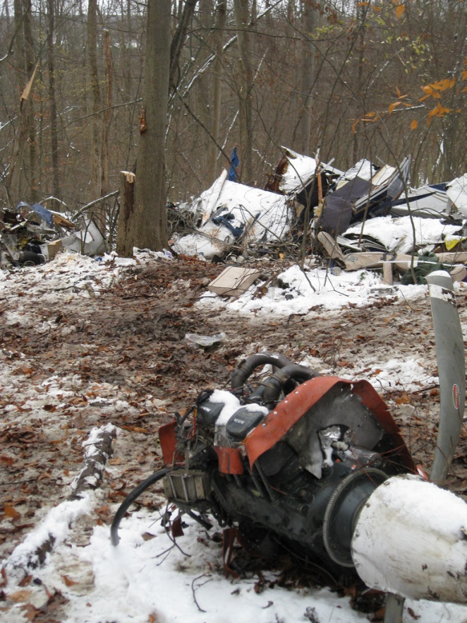
Photo: NTSB
Revision history:
| Date/time | Contributor | Updates |
|---|---|---|
| 02-Nov-2020 04:31 | Geno | Added |
| 02-Nov-2020 04:36 | Geno | Updated [Aircraft type, Source] |
| 02-Nov-2020 16:47 | Anon. | Updated [Total fatalities, Nature, Source] |
| 03-Nov-2020 13:29 | aaronwk | Updated [Time, Location, Source, Damage, Narrative] |
| 03-Nov-2020 13:37 | Aerossurance | Updated [Location] |
| 03-Nov-2020 21:35 | Captain Adam | Updated [Registration, Other fatalities, Location, Narrative] |
| 10-Jul-2021 09:26 | aaronwk | Updated [Location, Source, Narrative, Category] |
| 07-Oct-2022 04:46 | Captain Adam | Updated [Time, Source, Narrative, Accident report, Photo] |
Corrections or additions? ... Edit this accident description
The Aviation Safety Network is an exclusive service provided by:
Quick Links:
| ASN Home | Send Correction / Feedback |
| FSF Home | Disclaimer | Copyright |
| Contact Us | Privacy Policy |
| Press / Media |
 ©2024 Flight Safety Foundation