ASN Wikibase Occurrence # 245903
This information is added by users of ASN. Neither ASN nor the Flight Safety Foundation are responsible for the completeness or correctness of this information.
If you feel this information is incomplete or incorrect, you can submit corrected information.
| Date: | Sunday 20 December 2020 |
| Time: | 20:11 |
| Type: |  Cessna 210L Centurion |
| Owner/operator: | Coastal Flight Surgeons Inc |
| Registration: | N2246S |
| MSN: | 21061190 |
| Year of manufacture: | 1976 |
| Total airframe hrs: | 5193 hours |
| Engine model: | Continental IO 520 L |
| Fatalities: | Fatalities: 1 / Occupants: 1 |
| Aircraft damage: | Destroyed |
| Category: | Accident |
| Location: | Midway, GA -
 United States of America United States of America
|
| Phase: | En route |
| Nature: | Private |
| Departure airport: | Swainsboro-Emanuel County Airport, GA (KSBO) |
| Eagle Neck Airport, GA (1GA0) | |
| Investigating agency: | NTSB |
| Confidence Rating: |
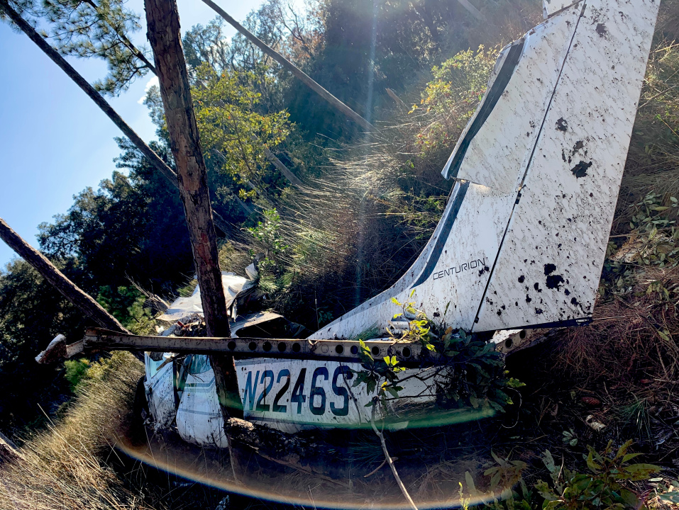
On December 20, 2020, about 2011 eastern standard time, a Cessna 210L, N2246S, was substantially damaged when it was involved in an accident near Midway, Georgia. The private pilot was fatally injured. The airplane was operated as a Title 14 Code of Federal Regulations Part 91 personal flight.
The pilot departed on a visual flight rules (VFR) flight into night instrument meteorological conditions (IMC) to an airport that was not equipped with any instrument approach procedures. Automatic dependent surveillance-broadcast (ADS-B) data showed that, in the final minutes of the accident flight, the pilot turned toward the airport, descended below the reported overcast cloud layer, and flew at altitudes between 100 to 300 ft mean sea level at groundspeeds of 100 to 115 knots. While descending, the airplane impacted 80-100 ft tall pine trees about 5 nautical miles from the destination airport. The pilot’s son reported that the pilot used a GPS and an app on his personal electronic device (PED) in which he had “built a flight path” into the destination airport. It was customary for the pilot to use this app and descend to pattern altitude or below cloud level, then continue to the airport by reference to the ground and the app.
Postaccident examination of the airplane revealed no preimpact mechanical anomalies that would have precluded normal operation. The distribution of the wreckage indicated that the airplane impacted terrain in a near-level attitude with high forward velocity.
There was no indication that the pilot obtained a weather briefing before departure; however, he did discuss the poor weather conditions at the destination airport with his son via text message and stated that he would check the weather before he departed. Although the pilot was instrument rated, he chose to fly VFR in low instrument flight rules (IFR) conditions over a dark swamp into an airport with no instrument approach procedures rather than file an IFR flight plan to an airport with an instrument approach. The pilot was expected at work at a nearby hospital emergency room the next morning, and it is likely that his desire to be at work contributed to his decision.
Although conditions were conducive to the development of spatial disorientation, the airplane’s low impact angle was more consistent with controlled flight into terrain rather than a loss of control due to spatial disorientation. The extremely low altitude and moderate speeds at which the pilot was operating under the impoverished visual conditions at the time of the accident, and his reported use of a PED for navigation and hazard avoidance, would have made precise altitude control challenging given the division of attention and workload required. Given the impoverished visual conditions, low altitude, and the distance from the airport, the pilot likely would have had difficulty identifying the airport environment. He may have been attempting to locate the airport and lost awareness of the airplane’s altitude as it continued to descend until it impacted trees.
Probable Cause: The pilot's intentional visual flight rules flight into instrument meteorological conditions, which resulted in controlled flight into terrain. Contributing to the accident was the pressure to complete the flight to work in an emergency room.
Accident investigation:
 |
|
Sources:
https://www.google.com/amp/s/www.wtoc.com/2020/12/21/first-responders-trying-reach-downed-aircraft-liberty-co/%3foutputType=amp
NTSB
https://flightaware.com/live/flight/N2246S
https://registry.faa.gov/AircraftInquiry/Search/NNumberResult?NNumberTxt=2246S
https://photos-e1.flightcdn.com/photos/retriever/5b192cd4602e080f4d99f0c7df7db3cf3357015a (photo)
History of this aircraft
Other occurrences involving this aircraft
| 8 July 2017 | N2246S | Coastal Flight Surgeons Inc | 0 | Ossabaw Island, GA |  |
non |
Location
Images:

Photo: Liberty County Sheriff
Media:
NTSB is investigating the Mon., Dec. 21, 2020, crash of a Cessna 210, Midway, GA. NTSB is not traveling to the crash scene at this time.
— NTSB_Newsroom (@NTSB_Newsroom) December 21, 2020
Revision history:
| Date/time | Contributor | Updates |
|---|---|---|
| 21-Dec-2020 23:48 | Captain Adam | Added |
| 22-Dec-2020 03:27 | RobertMB | Updated [Aircraft type, Registration, Cn, Operator, Source, Embed code] |
| 22-Dec-2020 04:50 | Geno | Updated [Date, Time, Operator, Source] |
| 22-Dec-2020 04:51 | Geno | Updated [Operator] |
| 22-Dec-2020 05:20 | Geno | Updated [Destination airport] |
| 10-Jul-2021 09:26 | aaronwk | Updated [Time, Location, Departure airport, Source, Narrative, Category] |
| 20-Oct-2022 19:51 | Captain Adam | Updated [Source, Narrative, Accident report, Photo] |
Corrections or additions? ... Edit this accident description
The Aviation Safety Network is an exclusive service provided by:


 ©2024 Flight Safety Foundation