

ASN Wikibase Occurrence # 261791
This information is added by users of ASN. Neither ASN nor the Flight Safety Foundation are responsible for the completeness or correctness of this information.
If you feel this information is incomplete or incorrect, you can submit corrected information.
| Date: | Monday 17 May 2021 |
| Time: | 13:08 |
| Type: |  Cessna 182H Skylane |
| Owner/operator: | Gateway Air Service Inc |
| Registration: | N2430X |
| MSN: | 18256330 |
| Year of manufacture: | 1965 |
| Total airframe hrs: | 6744 hours |
| Engine model: | Continental O-470-R |
| Fatalities: | Fatalities: 1 / Occupants: 1 |
| Aircraft damage: | Destroyed |
| Category: | Accident |
| Location: | St. Louis, MI -
 United States of America United States of America
|
| Phase: | En route |
| Nature: | Aerial patrol |
| Departure airport: | Romeo State Airport, MI (D98) |
| Clare Municipal Airport, MI (48D) | |
| Investigating agency: | NTSB |
| Confidence Rating: |
On May 17, 2021, about 1308 eastern daylight time, a Cessna 182H airplane, N2430X, was destroyed when it was involved in an accident near St. Louis, Michigan. The pilot was fatally injured. The airplane was operated as a Title 14 Code of Federal Regulations Part 91 pipeline patrol flight.
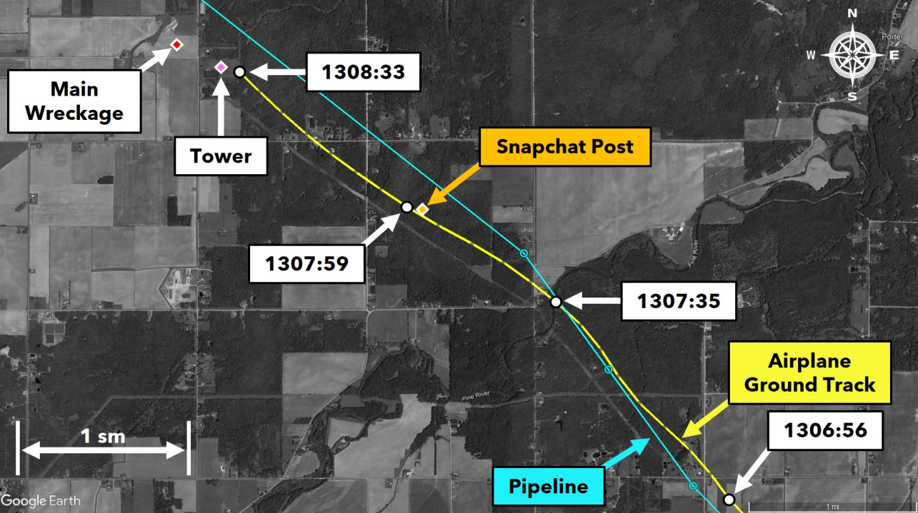
The pilot was conducting a low-altitude pipeline patrol flight in day visual meteorological conditions when the airplane collided with a radio tower guy wire. According to radar data, during the final 4.5 minutes of the flight, the airplane’s altitude was between 475 and 800 ft above ground level (agl). The airplane’s ground track was offset to the right of the pipeline until about the final minute of the flight, at which point the airplane crossed over the pipeline and continued about 1,000 to 1,250 ft to the left of the pipeline. The operator reported that the airplane should be flown to the right of the pipeline to ensure that the pilot, who is seated in the left cockpit seat, can maintain an unobstructed view of the pipeline during the patrol flight.
The airplane continued northwest toward the radio tower. About 15 seconds before the accident, the airplane was about 0.65 miles southeast of the tower in a shallow right turn when it entered a climb from 475 ft agl. At the final radar return, about 600 ft east-southeast of the tower, the airplane’s altitude, calibrated airspeed, and climb rate were about 1,370 ft msl, 104 knots, and 1,575 ft per minute, respectively. The airplane’s final altitude was 370 ft below the top of the radio tower and its ground track was toward the guy wires located on the northeast side of the radio tower. Based on the airplane’s ground track and rapidly increasing climb rate, the pilot was likely trying to avoid the tower guy wires during the final moments of the flight.
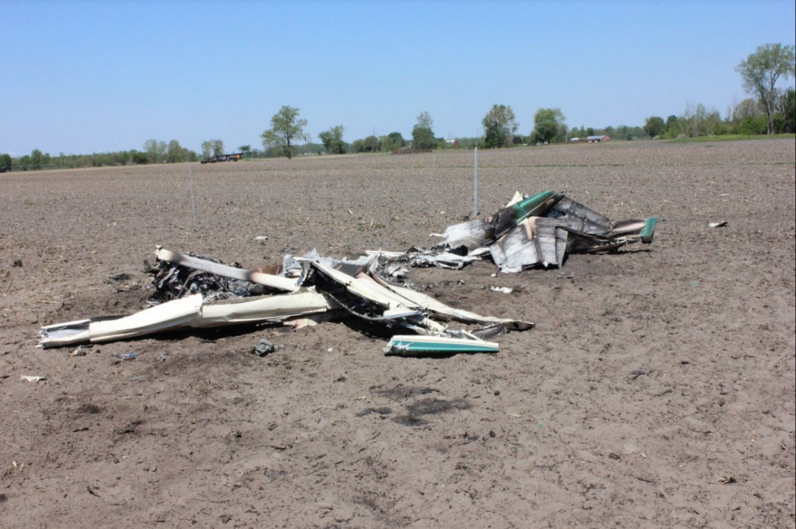
The airplane’s left wing separated from the fuselage at the wing root when it collided with a support guy wire attached to the northeast side of the radio tower. The airplane then impacted a dirt field about 0.3 mile northwest of the radio tower where a postimpact fire destroyed most of the airplane. Postaccident examination of the airplane wreckage did not reveal any evidence of a mechanical malfunction or failure that would have prevented normal operation of the airplane before it collided with the tower guy wire.
Two individuals reported that the pilot posted a Snapchat video shortly before the accident. The Snapchat video reportedly depicted the terrain ahead of the airplane while it was 5 to 10 miles southeast of the accident site. Although the video was automatically deleted from the Snapchat platform 24 hours after the accident, it reportedly did not include the final moments of the flight. One of the individuals provided a screenshot of the Snapchat application’s map that showed the approximate location of where the pilot posted the video. When compared to the airplane’s recorded radar ground track, the location of the pilot’s Snapchat post was about 1.5 miles southeast of the radio tower, and likely was posted about 35 seconds before the accident. The airplane’s ground track was already left of the pipeline when the pilot posted the Snapchat video. Based on the known information, it is likely the pilot was distracted while he used his mobile device in the minutes before the accident and did not maintain an adequate visual lookout to ensure a safe flight path to avoid the radio tower and its guy wires.
Probable Cause: The pilot’s failure to maintain adequate visual lookout to ensure clearance from the radio tower and its guy wires. Contributing to the accident was the pilot’s unnecessary use of his mobile device during the flight, which diminished his attention/monitoring of the airplane’s flight path.
Accident investigation:
 |
|
Sources:
https://www.abc12.com/2021/05/17/fiery-plane-crash-claims-life-of-23-year-old-pilot/
https://www.miheadlines.com/2021/05/17/fiery-plane-crash-kills-pilot-in-midland-county/
NTSB
https://data.ntsb.gov/Docket?ProjectID=103091
https://registry.faa.gov/aircraftinquiry/Search/NNumberResult?nNumberTxt=2430X
https://www.airport-data.com/images/aircraft/000/046/046782.jpg (photo)
History of this aircraft
Other occurrences involving this aircraft
| 30 January 2017 | N2430X | Gateway Air Service Inc | 0 | Midland County, Mills Township, MI | |
non |
Location
Images:
Revision history:
| Date/time | Contributor | Updates |
|---|---|---|
| 17-May-2021 21:23 | Captain Adam | Added |
| 17-May-2021 23:10 | Geno | Updated [Time, Total fatalities, Total occupants, Other fatalities, Source, Embed code] |
| 18-May-2021 12:39 | RobertMB | Updated [Registration, Cn, Operator, Location, Phase, Nature, Source, Damage, Narrative] |
| 20-May-2021 21:36 | Captain Adam | Updated [Location, Narrative] |
| 20-May-2021 21:36 | Captain Adam | Updated [[Location, Narrative]] |
| 20-May-2021 21:36 | Captain Adam | Updated [[[Location, Narrative]]] |
| 20-Jul-2021 18:17 | aaronwk | Updated [Time, Location, Nature, Departure airport, Source, Narrative, Category] |
| 17-Aug-2023 18:54 | Captain Adam | Updated [[Time, Location, Nature, Departure airport, Source, Narrative, Category]] |
Corrections or additions? ... Edit this accident description
The Aviation Safety Network is an exclusive service provided by:
Quick Links:
| ASN Home | Send Correction / Feedback |
| FSF Home | Disclaimer | Copyright |
| Contact Us | Privacy Policy |
| Press / Media |
 ©2024 Flight Safety Foundation