

ASN Wikibase Occurrence # 266801
This information is added by users of ASN. Neither ASN nor the Flight Safety Foundation are responsible for the completeness or correctness of this information.
If you feel this information is incomplete or incorrect, you can submit corrected information.
| Date: | Sunday 15 August 2021 |
| Time: | 18:47 |
| Type: |  Cessna 182H Skylane |
| Owner/operator: | Apache Air Service LLC |
| Registration: | N8477S |
| MSN: | 18256577 |
| Year of manufacture: | 1965 |
| Total airframe hrs: | 3966 hours |
| Engine model: | Continental 470-R |
| Fatalities: | Fatalities: 3 / Occupants: 3 |
| Aircraft damage: | Destroyed |
| Category: | Accident |
| Location: | Bountiful, UT -
 United States of America United States of America
|
| Phase: | Manoeuvring (airshow, firefighting, ag.ops.) |
| Nature: | Private |
| Departure airport: | Bountiful-Salt Lake Skypark, UT (BTF/KBTF) |
| Bountiful-Salt Lake Skypark, UT (BTF/KBTF) | |
| Investigating agency: | NTSB |
| Confidence Rating: |
On August 15, 2021, about 1847 mountain daylight time, a Cessna 182H, N8477S, was destroyed when it was involved in an accident near Bountiful, Utah. Two pilots and one passenger were fatally injured. The airplane was operated as a Title 14 Code of Federal Regulations Part 91 personal flight.
The pilot, who owned the dual-flight-control airplane, planned to take the other two occupants (one of whom was also a pilot) on a local tour flight to celebrate their 1-year wedding anniversary. The planned route could not be determined; however, friends and family members stated that they intended to fly past the temple where they were married.
Automatic dependent surveillance broadcast (ADS-B) equipment data indicated a nominal climb profile after takeoff, as the airplane flew past the temple and toward the entrance of a canyon. The airplane then entered the canyon while initially level with the top of its walls. However, as the flight progressed, the top of the canyon walls began to increase at a rate that exceeded the airplane’s climb performance.
Escape from the canyon during the initial stages would have required a precise and coordinated 180° turn that would have resulted in the airplane flying very close to terrain. Instead, the airplane continued until it reached a 1-mile-wide bowl at the end of the canyon that was surrounded by steep rising terrain. Data indicated that the airplane appeared to begin a left turn, possibly in preparation for a 180° turn to escape the canyon but by this time it was approaching the stall speed. The wreckage was located just beyond the final ADS-B target and damage to the airplane and surrounding vegetation was consistent with a near vertical impact, likely after the occurrence of an aerodynamic stall and resultant spin.
Propeller damage signatures along with the airplane’s climb performance indicated the engine was operating throughout. The airplane’s final flap position and observed speed as it passed the halfway point through the canyon were consistent with that required for best angle-of-climb performance. Therefore, the pilots were likely aware of the predicament not long after they entered the canyon.
Weather data indicated that the airplane would not have encountered mechanical turbulence often associated with mountain flight and that no downdrafts or updrafts were in the area.
A forest fire had resulted in smoke and reduced visibility in the entire area with visibility of 5 miles in smoke and haze. However, due to the prevailing wind direction, which pushed smoke toward the rising terrain, it is possible that visibility may have been even lower at the end of the canyon. Video footage of the mountains, along with the statement of a witness who was close to the accident site appeared to confirm this. An airman's meteorological information report indicating mountain obscuration due to smoke and haze was current at the time of the accident.
It could not be determined which pilot was flying the airplane at the time of the accident or why they chose to fly up the canyon. Both pilots were locally based and aware of the terrain. However, it is possible that the limited visibility caused them to misjudge the terrain and entry altitude. An established mountain pass, located 5 miles north of the accident location, followed a route that was about parallel to the accident flight. Although the entrance was indicated by a well-defined reporting point, it is possible that, with the low visibility and potential distractions related to the tour, the pilots may have missed this cue.
Although the owner had more experience flying the airplane, the other pilot had more flight experience and had previously provided the owner with flight instruction. It is possible that a diffusion of responsibility occurred; however, it was not possible to determine the command and decision-making power hierarchy during the accident flight.
Probable Cause: The decision of both pilots to fly into a steep canyon, which resulted in the airplane being unable to maintain a sufficient altitude to clear rising terrain. Contributing to the accident was their delayed initial action in responding to the hazard, and their failure to recognize the danger due to mountain obscuration caused by thick haze and smoke.
Accident investigation:
 |
|
Sources:
https://www.deseret.com/platform/amp/utah/2021/8/16/22627629/3-dead-in-small-plane-crash-east-of-bountiful?utm_campaign=ashley_imlay&utm_content=chorus&utm_medium=social&utm_source=twitter&__twitter_impression=true
NTSB
https://registry.faa.gov/AircraftInquiry/Search/NNumberResult?nNumberTxt=N8477S
https://globe.adsbexchange.com/?icao=ab9d38&lat=40.907&lon=-111.863&zoom=13.5&showTrace=2021-08-16×tamp=1629074712
https://flightaware.com/live/flight/N8477S
Photo: https://www.hangar67.com/photos/11962/22041d6879.jpg (photo)
Location
Images:
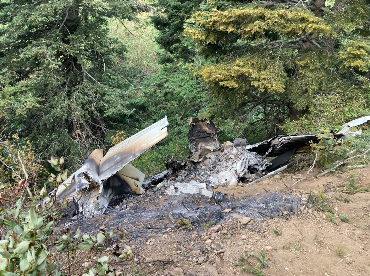
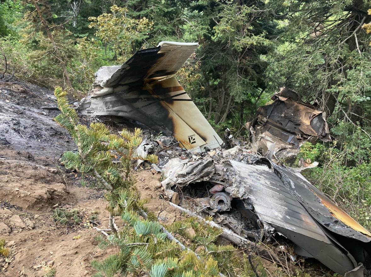
Photos: NTSB
Media:
NTSB investigating the Aug. 15, 2021, crash of a Cessna 182 airplane in Bountiful, UT.
— NTSB_Newsroom (@NTSB_Newsroom) August 16, 2021
Revision history:
| Date/time | Contributor | Updates |
|---|---|---|
| 16-Aug-2021 12:39 | gerard57 | Added |
| 16-Aug-2021 12:46 | RobertMB | Updated [Time, Aircraft type, Registration, Cn, Operator, Location, Source, Narrative] |
| 16-Aug-2021 15:12 | Iceman 29 | Updated [Source, Embed code] |
| 16-Aug-2021 15:36 | Anon. | Updated [Departure airport, Source, Damage, Category] |
| 17-Aug-2021 04:21 | Iceman 29 | Updated [Source, Embed code] |
| 17-Aug-2021 04:27 | Iceman 29 | Updated [Source, Embed code] |
| 31-Aug-2021 08:01 | aaronwk | Updated [Time, Destination airport, Source, Damage, Narrative] |
| 12-Oct-2021 21:18 | Captain Adam | Updated [Location, Narrative] |
Corrections or additions? ... Edit this accident description
The Aviation Safety Network is an exclusive service provided by:
Quick Links:
| ASN Home | Send Correction / Feedback |
| FSF Home | Disclaimer | Copyright |
| Contact Us | Privacy Policy |
| Press / Media |
 ©2024 Flight Safety Foundation