

ASN Wikibase Occurrence # 267491
This information is added by users of ASN. Neither ASN nor the Flight Safety Foundation are responsible for the completeness or correctness of this information.
If you feel this information is incomplete or incorrect, you can submit corrected information.
| Date: | Thursday 9 September 2021 |
| Time: | 14:27 LT |
| Type: |  Cessna 402C |
| Owner/operator: | Cape Air |
| Registration: | N88833 |
| MSN: | 402C0265 |
| Year of manufacture: | 1980 |
| Total airframe hrs: | 36722 hours |
| Engine model: | Continental IO-520-VB |
| Fatalities: | Fatalities: 0 / Occupants: 7 |
| Aircraft damage: | Substantial |
| Category: | Accident |
| Location: | Provincetown Municipal Airport (PVC/KPVC), MA -
 United States of America United States of America
|
| Phase: | Landing |
| Nature: | Passenger - Scheduled |
| Departure airport: | Boston-Logan International Airport, MA (BOS/KBOS) |
| Provincetown Airport, MA (PVC/KPVC) | |
| Investigating agency: | NTSB |
| Confidence Rating: |
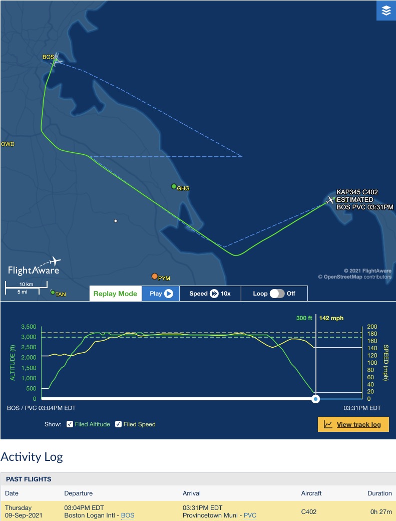
The pilot was transporting six passengers on a scheduled revenue flight in instrument meteorological conditions. The pilot familiarized himself with the weather conditions before departure and surmised that he would be executing the instrument landing system (ILS) instrument approach for the landing runway at the destination airport. The operator prohibited approaches to runways less than 4,000 ft long if the tailwind component was 5 knots or more. The landing runway was 498 ft shorter than the operator-specified length.
The pilot said he obtained the automated weather observing system (AWOS) data at least twice during the flight since he was required to obtain it before starting the instrument approach and then once again before he crossed the approach's final-approach-fix (FAF). Though the pilot could not recall when he checked the AWOS, he said the conditions were within the airplane and company performance limits and he continued with the approach. A review of the wind data at the time he accepted the approach revealed the tailwind component was within limitations.
As the airplane approached the FAF, wind speed increased, and the tailwind component ranged between 1 and 7 knots. Since the exact time the pilot checked the AWOS is unknown, it is possible that he obtained an observation when the tailwind component was within operator limits; however, between the time that the airplane crossed over the FAF and the time it landed, the tailwind component increased above 5 knots.
The pilot said the approach was normal until he encountered a strong downdraft when the airplane was about 50 to 100 ft above the ground. He said that the approach became unstabilized and that he immediately executed a go-around; the airplane touched down briefly before becoming airborne again. The pilot said he was unable to establish a positive rate of climb and the airplane impacted trees off the end of the runway.
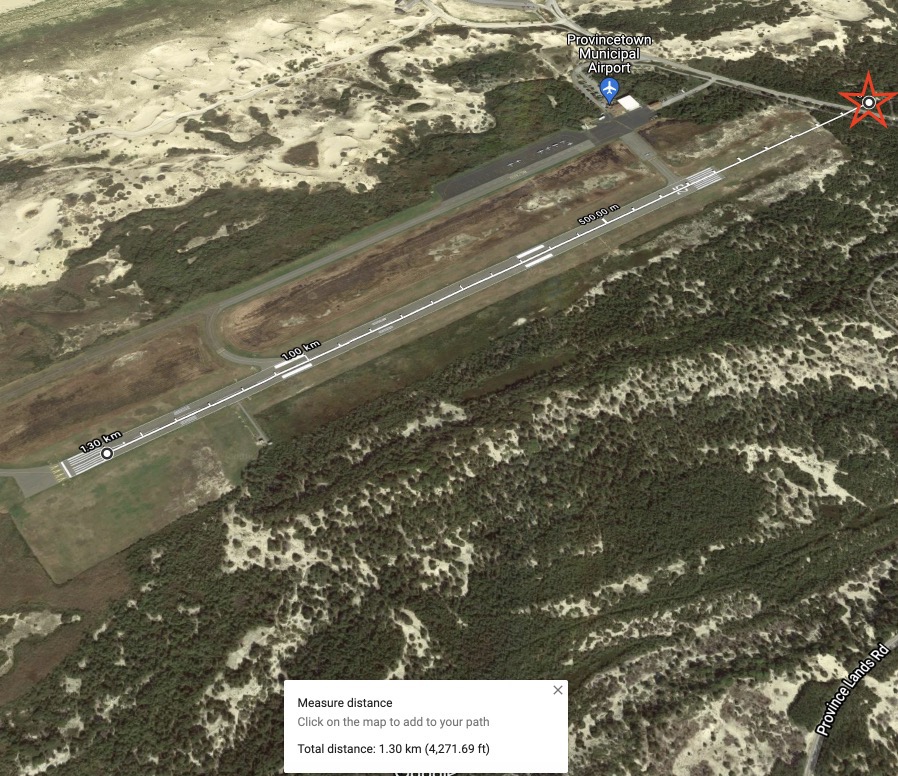
The accident was captured on three airport surveillance cameras. A study of the video data revealed the airplane made a normal landing and touched down about 500 ft from the beginning of the runway. It was raining heavily at the time. The airplane rolled down the runway for about 21 seconds, and then took off again. The airplane entered a shallow climb, collided with trees, and caught on fire.
An airplane performance study was conducted using automatic dependent surveillance – broadcast (ADS-B) data, weather information, and aircraft performance data provided by the manufacturer. The study revealed that the approach became unstabilized when the airplane exceeded a sink rate of 1,000 ft/minute at 400 ft above mean sea level (msl). Per the operator's General Operations Manual (GOM), the pilot should have immediately executed a missed approach.
In addition, the wind speed and tailwind component increased as the airplane was on approach. Consequently, the airplane landed at a calibrated airspeed that was about 18 knots faster than the speed assumed in the pilot operating handbook (POH)/airplane flight manual (AFM) landing distance tables, with a tailwind component of about 11 knots.
Landing performance calculations indicated that even with the fast touchdown speed, the airplane had sufficient runway available to stop on a dry runway, including a 15% safety margin. However, the combination of the fast touchdown speed and reduced deceleration due to the wet runway significantly increased the distance that would have been required to stop the airplane. The video study revealed that if the pilot just continued to let the airplane decelerate on the runway, it would have stopped somewhere between 60 ft before the end of the runway to 88 ft beyond the end of the runway.
Due to the reduced deceleration, the pilot most likely thought the airplane was going to go off the end of the runway and he opted to go-around. After lifting off, the airplane continued to accelerate at 5.0 ft/s2. Climb performance calculations revealed that it was unlikely that the airplane could have simultaneously maintained this acceleration and climbed out of ground effect. The airplane could have achieved a higher climb angle and likely cleared the trees if it had maintained a constant airspeed after liftoff, instead of accelerating, even though the liftoff airspeed was below the airplane's best angle of climb speed. However, it is understandable that a pilot would want to accelerate to this speed before climbing to clear obstacles.
Given the outcome of the attempted go-around, the performance data determined that the better option for the pilot would have been to accept an overrun into the open area beyond the end of the runway.
Probable Cause: The pilot's delayed decision to perform an aborted landing late in the landing roll with insufficient runway remaining. Contributing to the accident was the pilot's failure to execute a go-around once the approach became unstabilized, per the operator's procedures.
Accident investigation:
 |
|
Sources:
NTSB ERA21FA354
FAA register: https://registry.faa.gov/AircraftInquiry/Search/NNumberResult?nNumberTxt=88833
https://flightaware.com/live/flight/N88833
https://flightaware.com/resources/airport/PVC/IAP/ILS+OR+LOC+RWY+07/pdf
Location
Images:
Revision history:
| Date/time | Contributor | Updates |
|---|---|---|
| 09-Sep-2021 21:41 | Captain Adam | Added |
| 09-Sep-2021 23:53 | RobertMB | Updated [Date, Time, Registration, Cn, Location, Destination airport, Source, Narrative] |
| 10-Sep-2021 09:15 | Iceman 29 | Updated [Embed code, Damage] |
| 10-Sep-2021 09:16 | Iceman 29 | Updated [Embed code] |
| 10-Sep-2021 09:30 | Iceman 29 | Updated [Source] |
| 10-Sep-2021 09:30 | Iceman 29 | Updated [[Source]] |
| 10-Sep-2021 09:31 | Iceman 29 | Updated [Photo] |
| 10-Sep-2021 09:39 | Iceman 29 | Updated [Narrative] |
| 10-Sep-2021 09:39 | Iceman 29 | Updated [Category, Photo] |
| 10-Sep-2021 09:45 | Iceman 29 | Updated [Time, Operator, Source] |
| 10-Sep-2021 10:36 | Iceman 29 | Updated [Embed code] |
| 10-Sep-2021 10:44 | Iceman 29 | Updated [Embed code] |
| 10-Sep-2021 16:01 | aaronwk | Updated [Time, Embed code, Narrative] |
| 10-Sep-2021 17:38 | Iceman 29 | Updated [Time, Narrative] |
| 10-Sep-2021 19:52 | Anon. | Updated [Time, Source, Narrative] |
| 11-Sep-2021 07:28 | Anon. | Updated [Source] |
| 28-Sep-2021 16:57 | aaronwk | Updated [Time, Phase, Nature, Source, Narrative] |
| 18-Feb-2022 15:20 | Anon. | Updated [Narrative] |
| 19-Aug-2023 08:30 | ASN Update Bot | Updated [[Narrative]] |
| 19-Aug-2023 08:31 | harro | Updated [[[Narrative]]] |
Corrections or additions? ... Edit this accident description
The Aviation Safety Network is an exclusive service provided by:
Quick Links:
| ASN Home | Send Correction / Feedback |
| FSF Home | Disclaimer | Copyright |
| Contact Us | Privacy Policy |
| Press / Media |
 ©2024 Flight Safety Foundation