

ASN Wikibase Occurrence # 267786
This information is added by users of ASN. Neither ASN nor the Flight Safety Foundation are responsible for the completeness or correctness of this information.
If you feel this information is incomplete or incorrect, you can submit corrected information.
| Date: | Wednesday 15 September 2021 |
| Time: | 20:46 |
| Type: |  Robinson R66 Turbine |
| Owner/operator: | Monarch Helicopters Inc |
| Registration: | N888DV |
| MSN: | 1000 |
| Year of manufacture: | 2020 |
| Total airframe hrs: | 201 hours |
| Engine model: | Rolls Royce RR300-A1 |
| Fatalities: | Fatalities: 3 / Occupants: 3 |
| Aircraft damage: | Destroyed |
| Category: | Accident |
| Location: | Oconee National Forest near Monticello, GA -
 United States of America United States of America
|
| Phase: | En route |
| Nature: | Passenger - Non-Scheduled/charter/Air Taxi |
| Departure airport: | Thomasville Municipal Airport, GA (TVI/KTVI) |
| Atlanta-Fulton County Airport, GA (FTY/KFTY) | |
| Investigating agency: | NTSB |
| Confidence Rating: |
On September 15, 2021, at 2046 eastern daylight time, a Robinson R66 helicopter, N888DV, was destroyed when it was involved in an accident at the Oconee National Forest, near Monticello, Georgia. The commercial pilot, the pilot-rated passenger, and one other passenger sustained fatal injuries. The helicopter was operated as a Title 14 Code of Federal Regulations Part 135 on-demand charter flight.
The pilot, who was also the owner of the company, and a pilot-rated passenger were transporting a revenue-paying passenger on a chartered helicopter flight. The flight began on the morning of the accident with an approximately 200 nautical-mile flight to their destination before returning several hours later under visual flight rules. During the return trip, they stopped at an airport to refuel. About halfway through the subsequent flight, they encountered moderate to heavy rain showers. The passenger sent a text message to his spouse stating they landed in a field because “bad storms popped up” and they were waiting for it to blow over before resuming their flight. The message included a photograph that showed a grass field, gray skies, and rain on the helicopter’s window.
According to recorded flight track data, after departing the field, the pilot made a series of meandering track changes before proceeding to a nearby small airport where they stayed for about 5 minutes. Weather data indicated that after takeoff, the helicopter remained in areas of low ceilings and rain for the remainder of the flight. By this point in the flight, the sun had set and the end of civil twilight had passed. The helicopter subsequently passed 5 miles west of a city, then passed 2 miles east of a large powerplant before entering a large national wildlife refuge, a remote area covered with dense forest.
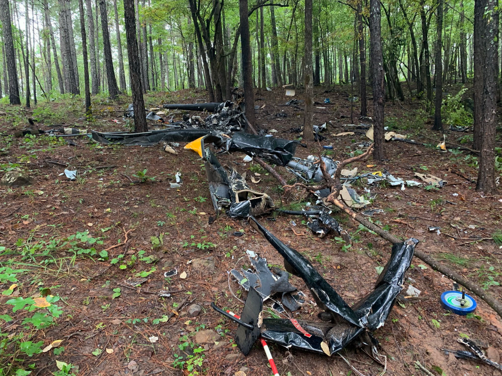
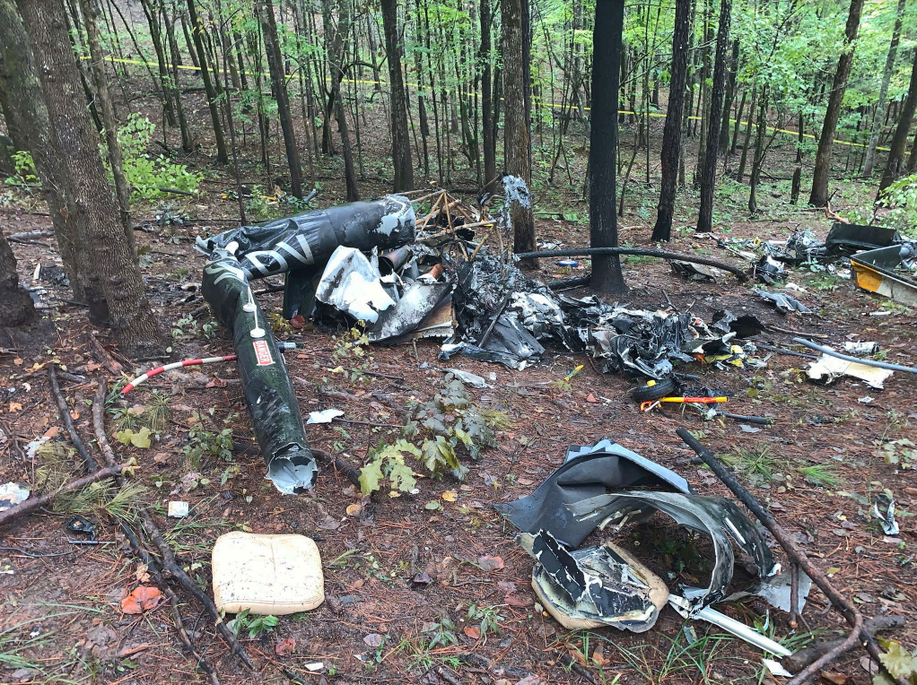
Shortly thereafter, the helicopter made a series of shallow left and right track changes. During the last 25 seconds of the flight, the helicopter entered a rapidly descending right turn and descended to ground impact. The calculated rate of descend reached nearly 4,000 feet per minute during the descent. The fragmentation of the wreckage and damage to surrounding trees revealed that the helicopter was in a 90° right bank as it came through the trees and impacted terrain.
Postaccident examination of the airframe, flight control system components, transmission, rotor system, and engine revealed no evidence of any preimpact mechanical malfunctions or failures that would have precluded normal operation. The helicopter was certified for operation in visual meteorological conditions (both day and night) and was not certified for operation in instrument meteorological conditions. While the helicopter was equipped with modern avionics that included tools like synthetic vision, as well as an autopilot system, the pilot’s proficiency in the use of the systems could not be determined based on available information.
Some or all the ethanol detected by postmortem toxicological testing in the pilot’s tissue may have been from sources other than consumption. It is unlikely that ethanol or impairment was a factor in the accident.
The weather conditions at the time of and preceding the accident consisted of low ceilings, low visibility, and rain with marginal visual meteorological conditions expected through most of the area. Once the helicopter passed the city and powerplant that contained ground reference lighting, and entered the national forest, the dark night conditions and sparse lighting along the flightpath would have made it even more difficult for the pilot to recognize and recover from a loss of control due to spatial disorientation. Based on the wreckage distribution, which was consistent with a high-energy impact, coupled with the known low visibility present at the time of the accident, it is likely that the pilot experienced spatial disorientation and lost control of the helicopter.
Probable Cause: The pilot’s decision to continue the visual flight rules flight into deteriorating weather conditions during a dark night and over unlit terrain, which resulted in spatial disorientation and a subsequent loss of helicopter control.
Accident investigation:
 |
|
Sources:
https://wgxa.tv/news/local/search-underway-after-helicopter-crash-in-jasper-county-faa
https://www.google.com/amp/s/www.11alive.com/amp/article/news/local/helicopter-crashes-into-oconee-national-forest-3-people-on-board/85-b091bf52-1207-4916-aaa2-bc6cd091c5ab
NTSB
https://data.ntsb.gov/Docket?ProjectID=103882
https://registry.faa.gov/aircraftinquiry/Search/NNumberResult?nNumberTxt=888DV
https://flightaware.com/live/flight/N888DV/history/20210915/2309Z/KTVI/L%2033.17852%20-83.77585
https://globe.adsbexchange.com/?icao=ac3bec&lat=33.192&lon=-83.874&zoom=11.0&showTrace=2021-09-16
https://weather.us/radar-us/f9225ef5e82cc919316be1397281174c/stormtracking/KJGX_20210916-004517z.html
https://photos-e1.flightcdn.com/photos/retriever/c92f98f4a0f81a5087b675da6e1d2dac3e5c5b80 (photo)
Location
Images:
Revision history:
| Date/time | Contributor | Updates |
|---|---|---|
| 16-Sep-2021 19:56 | Captain Adam | Added |
| 16-Sep-2021 21:24 | RobertMB | Updated [Time, Location, Nature, Source, Embed code, Damage, Narrative] |
| 17-Sep-2021 09:56 | Anon. | Updated [Source] |
| 17-Sep-2021 09:59 | harro | Updated [Registration, Cn, Operator, Location, Source, Narrative] |
| 17-Sep-2021 10:49 | RobertMB | Updated [Operator, Source] |
| 17-Sep-2021 18:27 | Captain Adam | Updated [Departure airport, Narrative] |
| 19-Sep-2021 09:47 | aaronwk | Updated [Narrative] |
| 21-Sep-2021 15:31 | johnwg | Updated [Source, Narrative, Category] |
| 16-Aug-2023 15:48 | Captain Adam | Updated [[Source, Narrative, Category]] |
Corrections or additions? ... Edit this accident description
The Aviation Safety Network is an exclusive service provided by:
Quick Links:
| ASN Home | Send Correction / Feedback |
| FSF Home | Disclaimer | Copyright |
| Contact Us | Privacy Policy |
| Press / Media |
 ©2024 Flight Safety Foundation