

ASN Wikibase Occurrence # 268495
This information is added by users of ASN. Neither ASN nor the Flight Safety Foundation are responsible for the completeness or correctness of this information.
If you feel this information is incomplete or incorrect, you can submit corrected information.
| Date: | Tuesday 12 October 2021 |
| Time: | 09:30 |
| Type: |  Glasair GlaStar |
| Owner/operator: | Private |
| Registration: | N628RS |
| MSN: | 5784 |
| Year of manufacture: | 2017 |
| Engine model: | Lycoming O-320-A2B |
| Fatalities: | Fatalities: 2 / Occupants: 2 |
| Aircraft damage: | Destroyed |
| Category: | Accident |
| Location: | near Waukesha, WI -
 United States of America United States of America
|
| Phase: | En route |
| Nature: | Private |
| Departure airport: | Milwaukee-Lawrence J Timmerman Airport, WI (KMWC) |
| Salina Airport, KS (SLN/KSLN) | |
| Investigating agency: | NTSB |
| Confidence Rating: |
On October 12, 2021, about 0930 central daylight time, an experimental, amateur-built Glastar airplane, N628RS, was destroyed when it was involved in an accident near Waukesha, Wisconsin. The pilot and passenger were fatally injured. The airplane was operated as a Title 14 Code of Federal Regulations (CFR) Part 91 personal flight.
The noninstrument-rated pilot departed under special visual flight rules into prevailing instrument meteorological conditions. About 2 hours before the flight, the pilot received a weather briefing that included an AIRMET for instrument flight rules conditions due to precipitation and mist. Although the departure airport was reporting cloud ceilings at 900 ft above ground level (agl) about the time of departure, nearby airports were reporting ceilings at 400 ft agl and visibilities of 3 miles in mist.
The pilot departed and maintained an altitude of about 1,200 ft mean sea level (msl), which was about 300-400 ft agl. The departure controller in communication with the pilot noted that the airplane had started to climb and asked if there was a gap in the cloud ceiling and whether he was attempting to climb above the clouds. The pilot responded in the affirmative. The airplane climbed to about 2,600 ft msl before it entered a left spiraling descent and subsequently impacted a residential area.
Variations in track data during the flight were inconsistent with the pilot using the airplane’s autopilot. A postaccident examination of the airplane did not reveal any anomalies that would have precluded normal operation.
The reduced visibility and low cloud conditions present at the time of the accident were conducive to the development of spatial disorientation, and the airplane’s spiraling descent is consistent with the known effects of spatial disorientation. It is likely that the pilot entered instrument meteorological conditions while attempting to climb above the clouds, experienced spatial disorientation, and subsequently lost control of the airplane.
Probable Cause: The noninstrument-rated pilot’s decision to depart and continue flight into instrument meteorological conditions, which resulted in a loss of control due to spatial disorientation.
Accident investigation:
 |
|
Sources:
https://patch.com/wisconsin/waukesha/small-plane-down-waukesha-neighborhood-report
https://www.tmj4.com/news/local-news/small-plane-crashes-in-waukesha-county-injuries-unknown-sheriffs-department
NTSB
FAA
https://registry.faa.gov/AircraftInquiry/Search/NNumberResult?nNumberTxt=628RS
https://globe.adsbexchange.com/?icao=a8357d
https://flightaware.com/live/flight/N628RS
https://archive.liveatc.net/kmke/KMKE3-App-Dep-Oct-12-2021-1400Z.mp3 (audio starts at ~18mins)
https://glasair-owners.com/wp-content/uploads/2017/04/N628RS-Glastar-Reimer-IMAG0324.jpg (photo)
Location
Images:
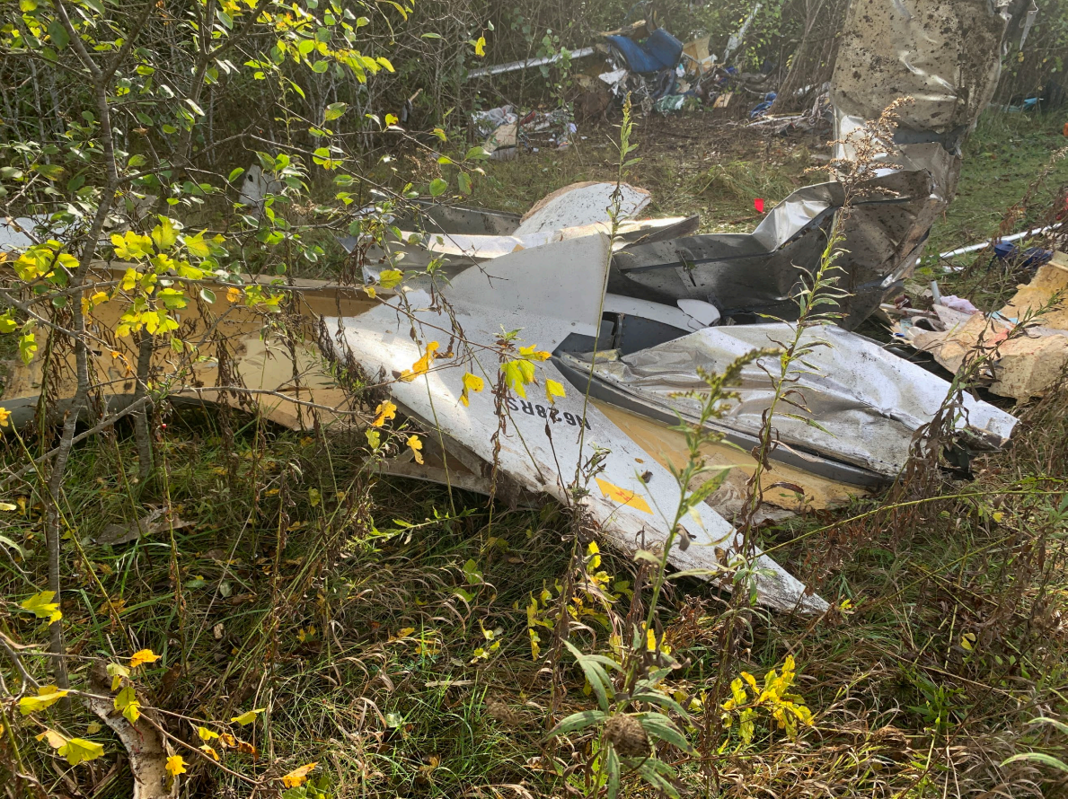
Photos: NTSB
Media:
NTSB is investigating the Oct. 12, 2021, crash of a Glastar near Waukesha, Wisconsin.
— NTSB_Newsroom (@NTSB_Newsroom) October 12, 2021
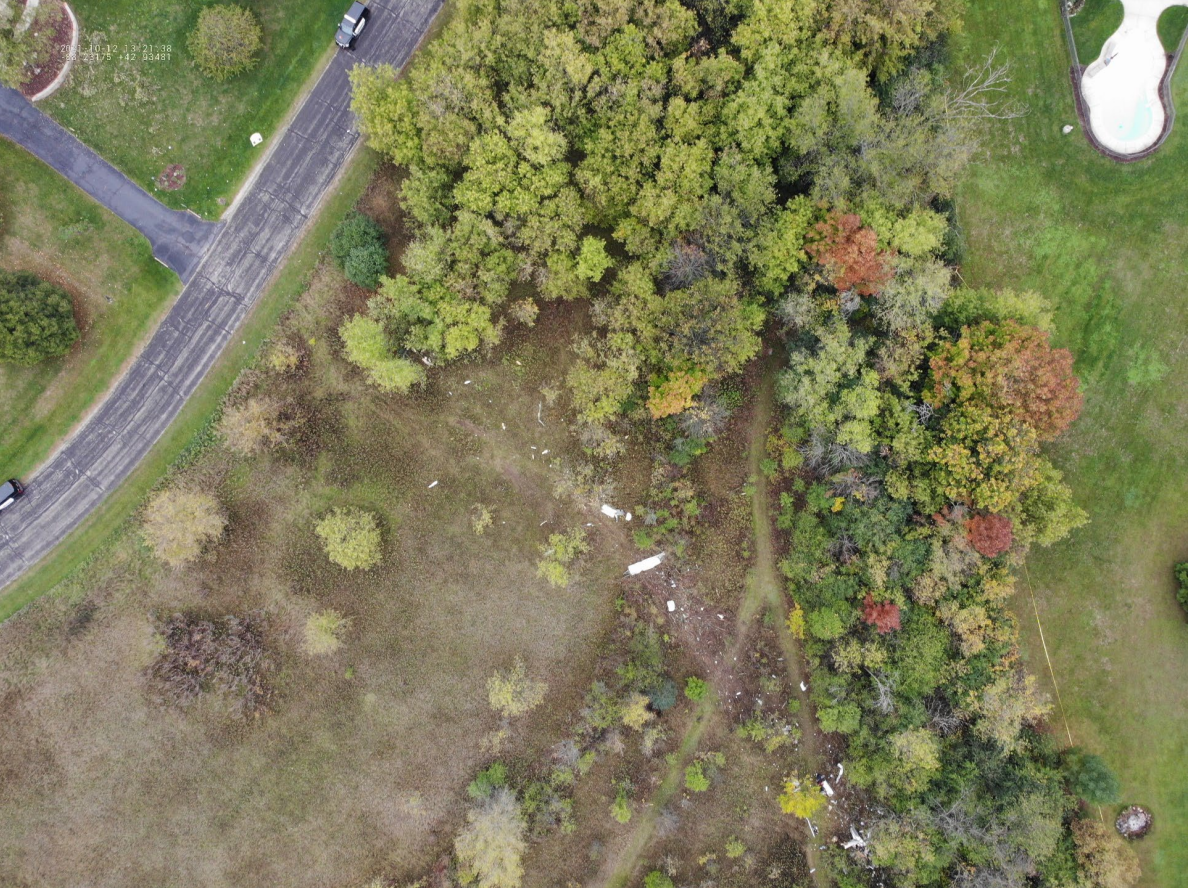
An Investigation is under way into a plane that crashed in Village of Waukesha today. Drone Team 4 with some birds eye shots outside of the perimeter. You can see what appears to be plane parts & investigators on the ground surveying the scene. more info as we get it @tmj4 pic.twitter.com/XRkeze7Tu2
— Gideon WVW (@GidTruth) October 12, 2021
Revision history:
| Date/time | Contributor | Updates |
|---|---|---|
| 12-Oct-2021 18:10 | Captain Adam | Added |
| 12-Oct-2021 19:57 | Geno | Updated [Source, Embed code] |
| 13-Oct-2021 09:28 | johnwg | Updated [Time, Aircraft type, Location, Source, Narrative, Category] |
| 13-Oct-2021 09:28 | harro | Updated [Aircraft type] |
| 13-Oct-2021 11:16 | RobertMB | Updated [Time, Location, Source, Narrative] |
| 13-Oct-2021 16:08 | acrispflyer | Updated [Source] |
| 13-Oct-2021 20:50 | Captain Adam | Updated [Location, Embed code, Narrative] |
| 14-Oct-2021 05:59 | johnwg | Updated [Time, Source, Embed code, Narrative] |
Corrections or additions? ... Edit this accident description
The Aviation Safety Network is an exclusive service provided by:
Quick Links:
| ASN Home | Send Correction / Feedback |
| FSF Home | Disclaimer | Copyright |
| Contact Us | Privacy Policy |
| Press / Media |
 ©2024 Flight Safety Foundation