

ASN Wikibase Occurrence # 269244
This information is added by users of ASN. Neither ASN nor the Flight Safety Foundation are responsible for the completeness or correctness of this information.
If you feel this information is incomplete or incorrect, you can submit corrected information.
| Date: | Thursday 28 October 2021 |
| Time: | 09:11 |
| Type: |  Mooney M20M / 257 TLS Bravo |
| Owner/operator: | Another Greaser LLC |
| Registration: | N40KA |
| MSN: | 27-0171 |
| Year of manufacture: | 1993 |
| Engine model: | Lycoming TIO-AF1B |
| Fatalities: | Fatalities: 1 / Occupants: 1 |
| Aircraft damage: | Destroyed |
| Category: | Accident |
| Location: | Snoqualmie, WA -
 United States of America United States of America
|
| Phase: | En route |
| Nature: | Private |
| Departure airport: | Arlington Municipal Airport, WA (AWO/KAWO) |
| Twin Falls City County Airport, ID (TWF/KTWF) | |
| Investigating agency: | NTSB |
| Confidence Rating: |
On October 28, 2021, about 0911 Pacific daylight time, a Mooney M20M, N40KA, was substantially damaged when it was involved in an accident near Snoqualmie, Washington. The private pilot sustained fatal injuries. The airplane was operated as a Title 14 Code of Federal Regulations Part 91 personal flight.
After a 6-year hiatus from flying, the pilot had just purchased the airplane. The morning of the accident flight, he filed an instrument flight rules (IFR) flight plan and received a weather briefing that identified icing conditions along the planned flight route. The pilot departed the airport about 0842 and planned to climb to an altitude of 17,000 ft mean sea level (msl). About 0901, the controller cleared the pilot to depart 14,000 ft msl and climb to 17,000 ft msl. Subsequently, the controller informed the pilot of multiple PIREPs for icing conditions from 12,000 ft msl to 18,000 ft msl and offered the pilot an altitude of 19,000 ft msl to get above the icing, which the pilot accepted.
About 0904, after climbing to an altitude of 16,300 ft msl, the airplane began a rapid descent with a series of tight spiral turns. Communication between the controller and the pilot became broken and unreadable. An airplane operating in the area relayed to the controller that the pilot reported being out of control. Shortly after 0910 radar contact was lost, and the airplane impacted terrain. It is likely that the accident airplane encountered structural icing and that the erratic turns coupled with a rapid descent rate were indicative of the pilot’s loss of airplane control, which resulted in a collision with terrain.
Postaccident examination of the engine and airframe revealed no evidence of mechanical malfunctions or failures that would have precluded normal operation. The supplement to the pilot’s operating handbook and the airplane flight manual contained a warning that stated, “INTENTIONAL FLIGHT INTO KNOWN ICING IS PROHIBITED.” The pilot’s logbook contained no record of a recent instrument proficiency check.
Probable Cause: The pilot’s decision to fly the airplane into known icing conditions, which resulted in a loss of airplane control and collision with terrain.
Accident investigation:
 |
|
Sources:
https://www.google.com/amp/s/www.king5.com/amp/article/news/local/wreckage-of-small-plane-crash-found-near-snoqualmie-pass-thursday/281-811eccfa-2fa5-4728-9efd-1ff4be3fc3bf
NTSB
https://flightaware.com/live/flight/N40KA/history/20211028/1530Z/KAWO/KTWF
https://www.airport-data.com/images/aircraft/001/373/001373314.jpg (photo)
Location
Images:
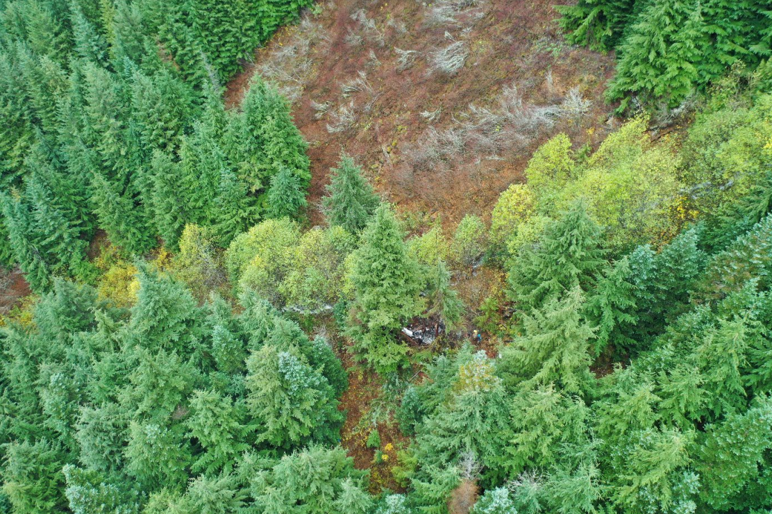
Photo: NTSB
Media:
The NTSB is investigating the crash Thursday of a Mooney M20M in Snoqualmie, Washington.
— NTSB_Newsroom (@NTSB_Newsroom) October 29, 2021
Revision history:
| Date/time | Contributor | Updates |
|---|---|---|
| 29-Oct-2021 08:20 | Captain Adam | Added |
| 29-Oct-2021 16:42 | Captain Adam | Updated [Time, Total fatalities, Total occupants, Other fatalities, Source, Embed code, Narrative] |
| 29-Oct-2021 19:13 | aaronwk | Updated [Time, Narrative] |
| 30-Oct-2021 04:37 | RobertMB | Updated [Aircraft type, Location, Source, Damage, Narrative] |
| 30-Oct-2021 06:26 | johnwg | Updated [Time, Aircraft type, Location, Source, Damage] |
| 30-Oct-2021 06:40 | RobertMB | Updated [Time, Aircraft type, Source, Narrative] |
| 30-Oct-2021 06:46 | RobertMB | Updated [Time, Location, Narrative] |
| 30-Oct-2021 13:05 | Captain Adam | Updated [Source, Narrative] |
| 12-Nov-2021 20:14 | aaronwk | Updated [Time, Location, Source, Narrative, Category] |
| 18-Nov-2021 16:51 | Captain Adam | Updated [Location, Narrative] |
Corrections or additions? ... Edit this accident description
The Aviation Safety Network is an exclusive service provided by:
Quick Links:
| ASN Home | Send Correction / Feedback |
| FSF Home | Disclaimer | Copyright |
| Contact Us | Privacy Policy |
| Press / Media |
 ©2024 Flight Safety Foundation