

ASN Wikibase Occurrence # 269285
This information is added by users of ASN. Neither ASN nor the Flight Safety Foundation are responsible for the completeness or correctness of this information.
If you feel this information is incomplete or incorrect, you can submit corrected information.
| Date: | Sunday 31 October 2021 |
| Time: | 13:20 |
| Type: |  Van's RV-4 |
| Owner/operator: | Private |
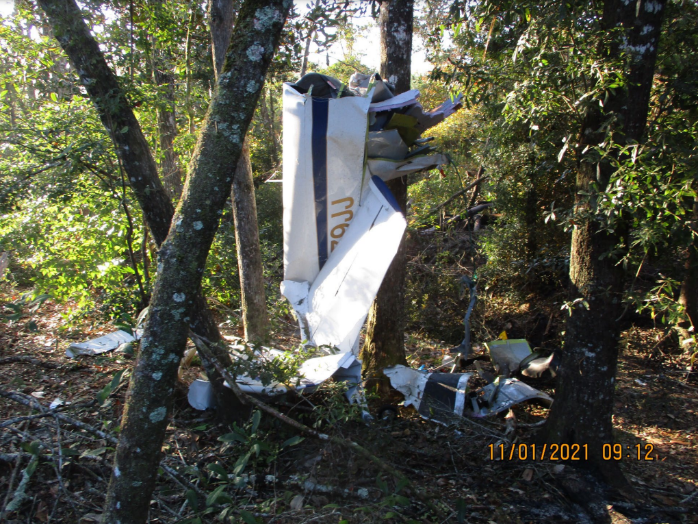
| Registration: | N479JJ |
| MSN: | 79 |
| Year of manufacture: | 2001 |
| Total airframe hrs: | 648 hours |
| Engine model: | Lycoming O-320-E2A |
| Fatalities: | Fatalities: 1 / Occupants: 1 |
| Aircraft damage: | Destroyed |
| Category: | Accident |
| Location: | near Quincy Municipal Airport (2J9), Chattahoochee, FL -
 United States of America United States of America
|
| Phase: | Initial climb |
| Nature: | Private |
| Departure airport: | Tallahassee International Airport, FL (TLH/KTLH) |
| Monroe County Airport, AL (MVC/KMVC) | |
| Investigating agency: | NTSB |
| Confidence Rating: |
On October 31, 2021, about 1320 eastern daylight time, an experimental, amateur-built Vans RV-4, N479JJ, was destroyed when it was involved in an accident near Chattahoochee, Florida. The pilot was fatally injured. The airplane was operated as a Title 14 Code of Federal Regulations Part 91 personal flight.
The pilot departed the airport for a cross country flight. Shortly after departure, radar services were terminated by air traffic control and the pilot was cleared for a radio frequency change. Seventeen minutes later, radar contact was lost. Automatic dependent surveillance-broadcast data obtained from the Federal Aviation Administration revealed the airplane climbed to about 2,500 ft mean sea level and made a few turns to the north and northeast before heading northwest. The airplane began to lose groundspeed, turned to the left and descended, then gained groundspeed as it continued to descend. The last data track showed the airplane at 650 ft and a groundspeed of 172 knots.
A witness was outside at his house when the canopy from the airplane fell in his yard. The canopy was about 1.5 miles away from the main wreckage. The accident site was in a wooded area and the wreckage path was about 550 ft long. The airplane was heavily fragmented and scattered along a debris path. The canopy handle was found in the open position with the looking pin damaged and bent at its tip. It is likely that the canopy was not locked correctly before takeoff and that it opened in flight and departed the airplane. The airplane then made a gradual slow left descending turn and continued to gain airspeed until it contacted trees and the ground at a high rate of speed. Based on the available evidence, it could not be determined if the canopy contacted and incapacitated the pilot when it separated from the airplane, which then resulted in a loss of control.
Probable Cause: The pilot’s failure to properly secure the canopy before takeoff, allowing the canopy to open and then separate in flight, which resulted in the pilot’s failure to maintain control of the airplane for reasons that could not be determined based on the available evidence.
Accident investigation:
 |
|
Sources:
https://www.wctv.tv/2021/10/31/authorities-investigating-plane-crash-gadsden-county/
https://data.ntsb.gov/Docket?ProjectID=104184
https://flightaware.com/live/flight/N479JJ
Location
Images:
Media:
The NTSB is investigating the crash Sunday of a Vans RV-4 in Chattahoochee, Florida.
— NTSB_Newsroom (@NTSB_Newsroom) October 31, 2021
Revision history:
| Date/time | Contributor | Updates |
|---|---|---|
| 31-Oct-2021 21:41 | Geno | Added |
| 31-Oct-2021 22:07 | Captain Adam | Updated [Aircraft type, Embed code] |
| 01-Nov-2021 16:33 | Captain Adam | Updated [Registration, Cn, Operator, Phase, Nature, Departure airport, Destination airport, Source, Embed code] |
| 18-Nov-2021 16:53 | Captain Adam | Updated [Location, Destination airport, Source, Damage, Narrative] |
| 06-Oct-2023 19:35 | Captain Adam | Updated [[Location, Destination airport, Source, Damage, Narrative]] |
Corrections or additions? ... Edit this accident description
The Aviation Safety Network is an exclusive service provided by:
Quick Links:
| ASN Home | Send Correction / Feedback |
| FSF Home | Disclaimer | Copyright |
| Contact Us | Privacy Policy |
| Press / Media |
 ©2024 Flight Safety Foundation