

ASN Wikibase Occurrence # 269336
This information is added by users of ASN. Neither ASN nor the Flight Safety Foundation are responsible for the completeness or correctness of this information.
If you feel this information is incomplete or incorrect, you can submit corrected information.
| Date: | Wednesday 3 November 2021 |
| Time: | 11:30 |
| Type: |  Ayres S-2R-T331 Turbo Thrush |
| Owner/operator: | Inland Cropdusters Inc |
| Registration: | N8960Q |
| MSN: | 2450R |
| Year of manufacture: | 1978 |
| Fatalities: | Fatalities: 1 / Occupants: 1 |
| Aircraft damage: | Destroyed |
| Category: | Accident |
| Location: | near Shafter-Minter Field Airport (MIT/KMIT), Shafter, CA -
 United States of America United States of America
|
| Phase: | Initial climb |
| Nature: | Agricultural |
| Departure airport: | Shafter-Kern County Airport, CA (MIT/KMIT) |
| New Cuyama Airport, CA (L88) | |
| Investigating agency: | NTSB |
| Confidence Rating: |
On November 3, 2021, about 1130 Pacific daylight time, a Thrush Ayers Corporation S-2R airplane, N8960Q, was destroyed when it was involved in an accident near Shafter, California. The pilot was fatally injured. The airplane was operated by Inland Aviation, Inc., as a Title 14 Code of Federal Regulations Part 91 repositioning flight prior to conducting aerial application activity.
The instrument-rated commercial pilot departed from the airport and was planning to conduct a visual flight rules aerial application flight in an airplane that was not equipped for instrument flight rules (IFR) operations. Shortly after departure, the airplane entered instrument meteorological conditions (IMC). The airplane impacted terrain about 1 1/4 mile from the departure airport.
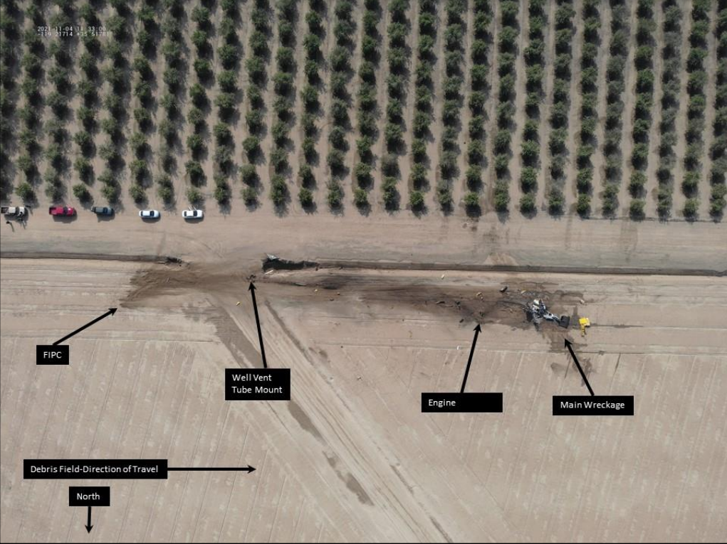
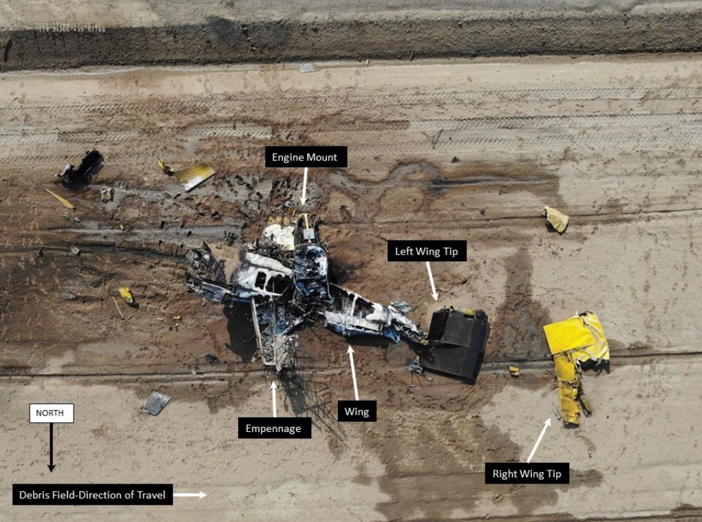
The wreckage field was about 800 ft in length. A postaccident examination of the airframe and engine revealed no mechanical anomalies that would have prevented normal operation.
A witness who spoke with the pilot before the flight reported that the pilot said that the fog had cleared for a few moments and that he had missed his opportunity to depart the airport. About 20-30 minutes later the pilot departed the airport with a 200 ft cloud ceiling and 1/2 mile of visibility.
Another witness who spoke with the pilot stated that the pilot had checked the weather. Multiple weather sources indicated low ceilings and the presence of fog, which is conductive to low IFR conditions, before and at the time of the accident for the area near the accident site.
Given the weather data and witness statements, the airplane likely flew into an area of fog and low clouds during departure and just before the accident. Based on the wreckage distribution, which was consistent with a high-speed impact, and the low visibility and ceiling present at the time of the accident, it is likely that the pilot experienced spatial disorientation and lost airplane control.
Probable Cause: The pilot’s decision to depart into instrument meteorological conditions, which resulted in spatial disorientation and a subsequent loss of airplane control.
Accident investigation:
 |
|
Sources:
https://bakersfieldnow.com/news/local/reports-of-an-air-plane-crash-in-shafter
https://www.bakersfield.com/news/plane-crashes-near-shafter-1-person-dead/article_5d85db3a-3ce1-11ec-a670-cb3f34319e84.html
https://www.turnto23.com/news/local-news/plane-crashes-near-shafter
https://data.ntsb.gov/Docket?ProjectID=104201
https://registry.faa.gov/AircraftInquiry/Search/NNumberResult?NNumberTxt=8960Q
https://www.airport-data.com/images/aircraft/000/331/331127.jpg (photo)
History of this aircraft
Other occurrences involving this aircraft
| 21 July 1998 | N8960Q | Inland Crop Dusters Inc. | 0 | Shafter, CA | |
sub |
Location
Images:
Photos: NTSB
Media:
The NTSB is investigating the crash Wednesday of a Ayres S-2R airplane in Shafter, California. An NTSB investigator is expected to arrive at the accident site on Thursday morning.
— NTSB_Newsroom (@NTSB_Newsroom) November 3, 2021
Revision history:
| Date/time | Contributor | Updates |
|---|---|---|
| 03-Nov-2021 19:35 | gerard57 | Added |
| 03-Nov-2021 19:59 | harro | Updated [Embed code, Damage, Narrative] |
| 03-Nov-2021 20:05 | harro | Updated [Location, Embed code, Narrative, Category] |
| 03-Nov-2021 20:54 | harro | Updated [Source, Embed code] |
| 04-Nov-2021 05:17 | RobertMB | Updated [Time, Operator, Total fatalities, Total occupants, Other fatalities, Location, Nature, Departure airport, Source, Narrative] |
| 04-Nov-2021 07:09 | Captain Adam | Updated [Aircraft type, Embed code, Narrative] |
| 04-Nov-2021 08:09 | RobertMB | Updated [Registration, Cn, Operator, Source, Embed code, Narrative] |
| 04-Nov-2021 13:27 | RobertMB | Updated [Aircraft type, Registration, Source, Narrative] |
| 09-Nov-2021 10:35 | Captain Adam | Updated [Narrative] |
| 06-Dec-2021 23:00 | Captain Adam | Updated [Destination airport, Source, Narrative, Category] |
| 06-Dec-2023 21:00 | Captain Adam | Updated [Time, Location, Phase, Destination airport, Source, Narrative, Accident report, Photo] |
| 06-Dec-2023 21:00 | Captain Adam | Updated [Photo] |
Corrections or additions? ... Edit this accident description
The Aviation Safety Network is an exclusive service provided by:
Quick Links:
| ASN Home | Send Correction / Feedback |
| FSF Home | Disclaimer | Copyright |
| Contact Us | Privacy Policy |
| Press / Media |
 ©2024 Flight Safety Foundation