

ASN Wikibase Occurrence # 270368
This information is added by users of ASN. Neither ASN nor the Flight Safety Foundation are responsible for the completeness or correctness of this information.
If you feel this information is incomplete or incorrect, you can submit corrected information.
| Date: | Wednesday 8 December 2021 |
| Time: | 19:57 |
| Type: |  Piper PA-28-140 Cherokee |
| Owner/operator: | Private |
| Registration: | N3865K |
| MSN: | 28-23754 |
| Year of manufacture: | 1967 |
| Engine model: | Lycoming 0-320-E2A |
| Fatalities: | Fatalities: 2 / Occupants: 2 |
| Aircraft damage: | Destroyed |
| Category: | Accident |
| Location: | near Houston-West Houston Airport (IWS/KIWS), TX -
 United States of America United States of America
|
| Phase: | Initial climb |
| Nature: | Private |
| Departure airport: | Houston-West Houston Airport, TX (IWS/KIWS) |
| Pearland Regional Airport, TX (LVJ) | |
| Investigating agency: | NTSB |
| Confidence Rating: |
On December 8, 2021, about 1957 central standard time, a Piper PA 28-140 airplane, N3865K, was destroyed when it was involved in an accident near Houston, Texas. The student pilot and passenger were fatally injured. The airplane was operated as a Title 14 Code of Federal Regulations Part 91 personal flight
The student pilot and passenger departed in the pilot’s recently purchased airplane into night instrument meteorological conditions. Flight track information indicated that the airplane departed the airport and proceeded generally south-southwest. The track showed a slight descending left turn and the airplane’s groundspeed increased. The airplane then made a slightly tighter, climbing right turn before entering a tight left descending turn toward the northeast, followed immediately by a hard right descending turn back to the southwest. The airplane’s descent rate continued to increase until contact was lost about 700 ft above the ground. There were no witnesses to the accident.
The airplane impacted trees and terrain about 2.5 miles southwest of the departure end of the runway. Examination of the airframe and engine did not reveal any anomalies that would have precluded normal operation.
Review of weather information indicated prevailing instrument meteorological conditions (IMC) in the area of the accident site due to low ceilings and visibility restricted in mist, with ceilings near 500 ft above ground level and tops near 2,000 ft mean sea level. There was no evidence that the pilot obtained a preflight weather briefing from an access-controlled source before departure.
Postaccident toxicology testing revealed that the pilot had used cannabis; low concentrations of tetrahydrocannabinol (THC) and its inactive metabolite, carboxy-delta-9-tetrahydrocannabinol (THC-COOH), were detected in his blood. Low concentrations of 11-OH-THC and THC-COOH were detected in his urine. Peak effects from using cannabis typically occur in the first couple of hours and concentrations of THC typically fall below 5 ng/mL after three hours. Since THC is stored in fatty tissues and is slowly released days and weeks after using cannabis, low concentrations can be detected long after use, especially in more chronic users. While the pilot’s pattern of cannabis use is unknown, given the low concentration of THC and THC-COOH in his blood, it is unlikely that the pilot was under the influence of THC at the time of the accident, and it is unlikely that the effects of his use of cannabis contributed to this accident.
The pilot’s lack of training in instrument meteorological conditions and at night were conducive to the development of spatial disorientation, and the airplane’s flight track was consistent with the known effects of spatial disorientation. Based on the available information, it is likely that the pilot encountered instrument meteorological conditions shortly after takeoff which resulted in his spatial disorientation and a loss of airplane control.
Probable Cause: The student pilot’s decision to depart into night instrument meteorological conditions, which resulted in spatial disorientation and a loss of airplane control.
Accident investigation:
 |
|
Sources:
https://abc13.com/harris-county-plane-crash-along-katy-freeway-service-road-reported-in-field/11316842/
https://www.khou.com/article/news/local/plane-crash-reported-in-west-harris-county/285-32e38300-9971-451a-af5e-a908528cdffe
https://www.khou.com/article/news/local/plane-crash-victims-identified-houston/285-47f03836-8d67-4295-b135-04059cce894e
NTSB
https://globe.adsbexchange.com/?icao=a474a5&lat=29.776&lon=-95.692&zoom=13.5&showTrace=2021-12-09
https://flightaware.com/live/flight/N3865K?fbclid=IwAR36TyIIVUBAuUvSbSrLovoKMRYkur6MwTTvsXGTlHWnrqYvb68qFTjBrMQ
https://www.airport-data.com/aircraft/photo/001262974.html (photo)
Location
Images:
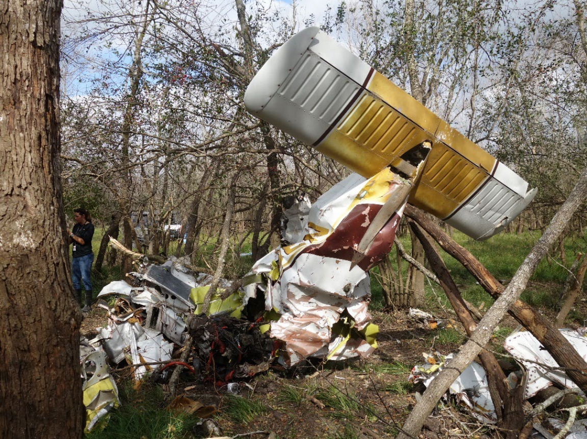
Photo: NTSB
Media:
The NTSB is investigating the crash of a Piper PA-28-140 airplane in West Houston, Texas.
— NTSB_Newsroom (@NTSB_Newsroom) December 9, 2021
Revision history:
| Date/time | Contributor | Updates |
|---|---|---|
| 09-Dec-2021 21:03 | Captain Adam | Added |
| 09-Dec-2021 21:53 | Geno | Updated [Date, Time, Aircraft type, Source] |
| 09-Dec-2021 22:08 | Captain Adam | Updated [Registration, Cn, Operator, Phase, Source] |
| 10-Dec-2021 01:54 | johnwg | Updated [Location, Nature, Destination airport, Source, Narrative] |
| 10-Dec-2021 03:07 | johnwg | Updated [Source, Narrative, Category] |
| 10-Dec-2021 07:42 | aaronwk | Updated [Narrative] |
| 10-Dec-2021 13:52 | johnwg | Updated [Time, Source, Narrative] |
| 10-Dec-2021 22:30 | Captain Adam | Updated [Location, Source, Embed code, Narrative] |
| 11-Dec-2021 23:43 | johnwg | Updated [Source, Embed code] |
| 17-Dec-2021 19:21 | Anon. | Updated [Source, Narrative] |
| 20-Dec-2021 19:36 | aaronwk | Updated [Source, Narrative, Category] |
| 17-Apr-2022 12:46 | Captain Adam | Updated [Source, Narrative] |
| 04-Sep-2022 16:32 | Captain Adam | Updated [Phase, Source, Narrative, Accident report, Photo] |
Corrections or additions? ... Edit this accident description
The Aviation Safety Network is an exclusive service provided by:
Quick Links:
| ASN Home | Send Correction / Feedback |
| FSF Home | Disclaimer | Copyright |
| Contact Us | Privacy Policy |
| Press / Media |
 ©2024 Flight Safety Foundation