

ASN Wikibase Occurrence # 270575
This information is added by users of ASN. Neither ASN nor the Flight Safety Foundation are responsible for the completeness or correctness of this information.
If you feel this information is incomplete or incorrect, you can submit corrected information.
| Date: | Sunday 12 December 2021 |
| Time: | 09:31 |
| Type: |  Cessna 310J |
| Owner/operator: | Private |
| Registration: | N3187L |
| MSN: | 310J0187 |
| Year of manufacture: | 1965 |
| Total airframe hrs: | 3936 hours |
| Engine model: | Continental IO-470-U |
| Fatalities: | Fatalities: 1 / Occupants: 1 |
| Aircraft damage: | Destroyed |
| Category: | Accident |
| Location: | Inola, OK -
 United States of America United States of America
|
| Phase: | En route |
| Nature: | Ferry/positioning |
| Departure airport: | Tulsa International Airport, OK (TUL/KTUL) |
| North Carolina | |
| Investigating agency: | NTSB |
| Confidence Rating: |
On December 12, 2021, about 0931 central standard time, a Cessna 310J airplane, N3187L, was destroyed when it was involved in an accident near Inola, Oklahoma. The pilot sustained fatal injuries. The airplane was operated as a Title 14 Code of Federal Regulations Part 91 ferry flight.
The airplane’s most recent flight was about 9 months before the accident, and the pilot was flying the airplane on a ferry permit to another location to complete an overdue annual inspection. Before the accident flight, the airplane’s fuel tanks were topped off, and the pilot completed a preflight inspection that took about 1 hour. After taxiing to the runway area, the pilot returned to the ramp due to an unknown right engine issue.
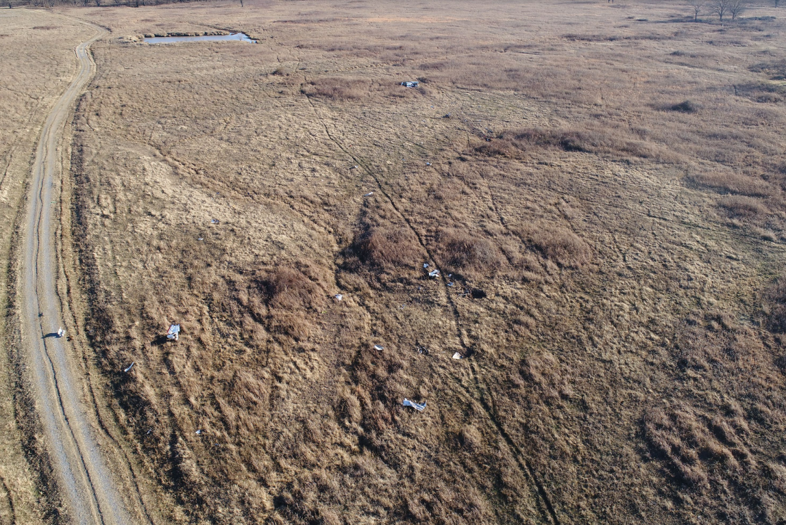
Following an extended engine run-up, the pilot taxied back to the runway and departed. Flight data showed that the airplane climbed to 5,800 ft mean sea level on an easterly heading, and about 1 minute before the accident, the airplane made a left turn to the north and began a rapid descent. For the last 23 seconds of the flight, the descent rate increased from about 1,000 to 30,000 ft per minute, and the ground speed varied between 151 and 198 knots. During the rapid descent and just before impact, the empennage and outboard wing sections separated. There were no emergency communications from the pilot and no witnesses to the accident.
Distribution of the wreckage and damage signatures observed during postaccident examination were indicative of an in-flight breakup at low altitude due to the exceedance of structure design limitations. The left cockpit propeller control lever was found in the feathered position. Both propellers displayed indications consistent with low power; however, exact engine power levels could not be determined. In addition, both propellers had impact signature markings indicating blade positions at or near feather blade angles during the impact sequence. Although the airframe and engine examinations revealed no evidence of mechanical malfunctions or failures, the extensive impact damage precluded a functional examination of the flight controls. Investigators were unable to determine the reason for the loss of control and rapid descent based on the available evidence.
The airframe and engine examinations revealed no evidence of mechanical malfunctions or failures that would have precluded normal operation.
Although the pilot tested positive for gabapentin, which is potentially sedating, tolerance to the sedating effects build quickly, and the pilot had likely been using the medication for some time. Thus, it is unlikely that any effects from the pilot’s use of gabapentin contributed to the circumstances of the accident.
Probable Cause: The loss of airplane control for reasons that could not be determined based on the available evidence.
Accident investigation:
 |
|
Sources:
https://www.newson6.com/story/61b645bcb54a5e0bf267b1fc/ohp:-fatality-confirmed-following-plane-crash-in-rogers-county-
https://www.krmg.com/news/one-dead-after-plane-crash-lands-rogers-county/NV2XJZBQPZCQTJWVCGQ5PNDZSU/
NTSB
https://flightaware.com/live/flight/N3187L/history/20211212/1459Z/KTUL/L%2036.20991%20-95.52390
https://globe.adsbexchange.com/?icao=a367e1&lat=36.210&lon=-95.531&zoom=14.7&showTrace=2021-12-12&trackLabels×tamp=1639323070
https://s3.eu-west-2.amazonaws.com/abpic-media-eu-production/pictures/full_size_0240/1361687-large.jpg (photo)
Location
Images:
Media:
The NTSB is investigating the crash Sunday of a Cessna 310 in Inola, Oklahoma.
— NTSB_Newsroom (@NTSB_Newsroom) December 13, 2021
Revision history:
| Date/time | Contributor | Updates |
|---|---|---|
| 12-Dec-2021 22:39 | Geno | Added |
| 13-Dec-2021 05:17 | RobertMB | Updated [Time, Aircraft type, Registration, Cn, Operator, Location, Phase, Nature, Departure airport, Source, Damage, Narrative] |
| 13-Dec-2021 20:12 | Captain Adam | Updated [Location, Nature, Source, Embed code, Narrative] |
| 14-Dec-2021 01:44 | johnwg | Updated [Time, Location, Source, Embed code, Narrative, Category] |
| 17-Dec-2021 12:01 | Captain Adam | Updated [Location, Source, Narrative] |
| 17-Dec-2021 15:08 | johnwg | Updated [Location, Source, Narrative] |
| 12-Jan-2022 16:55 | aaronwk | Updated [Time, Location, Source, Narrative, Category] |
| 18-Jan-2022 00:26 | Captain Adam | Updated [Destination airport, Source, Narrative] |
Corrections or additions? ... Edit this accident description
The Aviation Safety Network is an exclusive service provided by:
Quick Links:
| ASN Home | Send Correction / Feedback |
| FSF Home | Disclaimer | Copyright |
| Contact Us | Privacy Policy |
| Press / Media |
 ©2024 Flight Safety Foundation