ASN Wikibase Occurrence # 271253
This information is added by users of ASN. Neither ASN nor the Flight Safety Foundation are responsible for the completeness or correctness of this information.
If you feel this information is incomplete or incorrect, you can submit corrected information.
| Date: | Sunday 26 December 2021 |
| Time: | 17:29 |
| Type: |  Cessna 172E Skyhawk |
| Owner/operator: | Private |
| Registration: | N5789T |
| MSN: | 17251698 |
| Year of manufacture: | 1964 |
| Fatalities: | Fatalities: 2 / Occupants: 2 |
| Aircraft damage: | Destroyed |
| Category: | Accident |
| Location: | near Hardy, AR -
 United States of America United States of America
|
| Phase: | En route |
| Nature: | Private |
| Departure airport: | Gen-Airpark Airport, IL (3GB) |
| Walnut Ridge Airport, AR (ARG/KARG) | |
| Investigating agency: | NTSB |
| Confidence Rating: |
On December 26, 2021, about 1729 central standard time, a Cessna 172E airplane, N5798T, was destroyed when it was involved in an accident near Hardy, Arkansas. The private pilot and passenger sustained fatal injuries. The airplane was operated as a Title 14 Code of Federal Regulations Part 91 personal flight.
The non-instrument-rated private pilot was conducting a visual flight rules cross-country flight over mountainous terrain with a passenger in an airplane that was not equipped for instrument flight. There is no evidence that the pilot received a preflight weather briefing before the flight and the amount of fuel onboard the airplane at takeoff is unknown.
While en route, the pilot contacted air traffic control and requested the weather at his destination airport along with the weather at additional airports. When queried, he stated he was over his destination airport. Instrument meteorological conditions prevailed at the destination airport at the time. The pilot reported that he wanted to land because he had less than a quarter tank of fuel left, and he was going to continue flying west. Weather conditions further to the west were showing visual meteorological conditions at the time. The pilot informed air traffic control that he was setting up to land at an alternate airport when radar contact was lost.
Radar data showed the airplane was at an altitude of about 4,000 ft, about 2.5 nautical miles (nm) from the airport, when it turned right, descended slowly, and flew a track consistent with an attempt to make an approach. The airplane then entered a tight left turn and traveled to the north. During this time there were abrupt changes in ground speed, altitude, and the direction of flight. The airplane executed at least one sharp counterclockwise 360° turn before the data was lost.
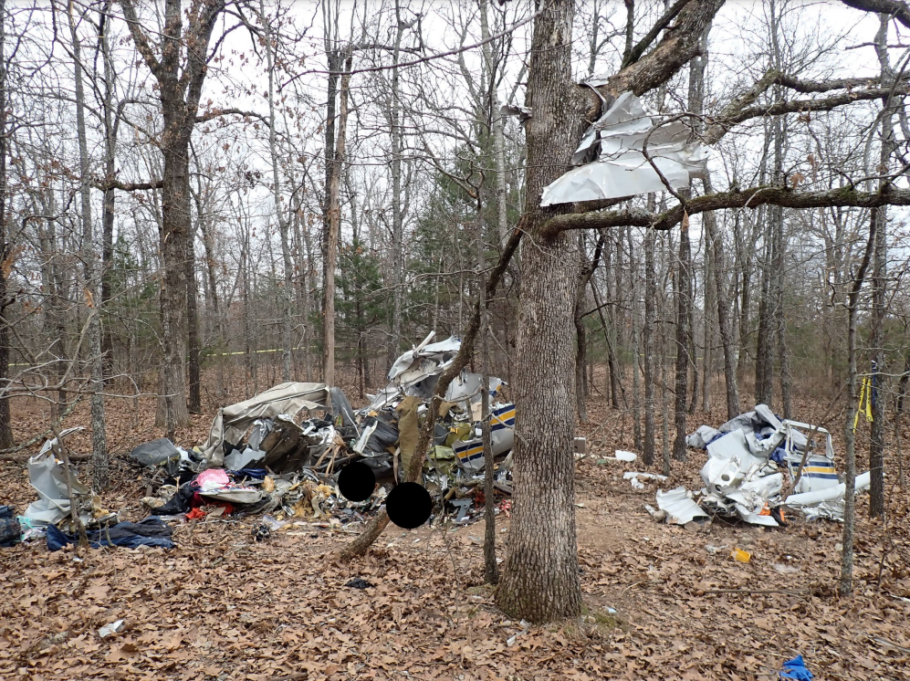
A review of meteorological data showed that low cloud ceilings, low visibility, and low-level windshear prevailed at the accident site. Based on the weather conditions and the flight track data, it is likely that the pilot encountered low cloud ceilings and low visibility conditions. The flight track data was consistent with the known effects of spatial disorientation. It is likely there were no outside visual references, the pilot had an increase in workload due to spatial disorientation, and he was unable to recover the airplane from its descent. The airplane impacted trees and terrain with a near-vertical descent angle. The airplane was destroyed.
One text messages that the passenger sent to a family member while in flight stated, “ran into weather can’t see anything” and another text message later stated, “out of gas in air.”
Examination of the airframe and the engine did not reveal any preimpact mechanical malfunctions or failures that would have precluded normal operation. There was no evidence of fuel at the accident site. The pilot had first reported to air traffic control that he had a low fuel status and then later reported that he had no fuel. The fuel exhaustion likely resulted in a loss of engine power; however, the pilot did not report this to air traffic control.
It is likely that the pilot decided to continue visual flight into an area of instrument meteorological conditions due to his low fuel status. The low fuel status eventually resulted in fuel exhaustion and a subsequent loss of engine power. The pilot’s continued flight into instrument meteorological conditions resulted in spatial disorientation and a loss of airplane control.
Probable Cause: The non-instrument rated pilot’s decision to continue visual flight into an area of instrument meteorological conditions, which resulted in a loss of control due to spatial disorientation. Contributing to the accident was a loss of engine power due to fuel exhaustion.
Accident investigation:
 |
|
Sources:
https://www.kait8.com/2021/12/27/first-responders-scene-plane-crash-near-sharp-fulton-county-line/
https://data.ntsb.gov/Docket?ProjectID=104443
https://registry.faa.gov/AircraftInquiry/Search/NNumberResult?nNumberTxt=5798T
https://flightaware.com/live/flight/N5798T
Location
Images:


Photos: NTSB
Revision history:
| Date/time | Contributor | Updates |
|---|---|---|
| 27-Dec-2021 01:14 | Captain Adam | Added |
| 27-Dec-2021 16:42 | Geno | Updated [Source] |
| 28-Dec-2021 00:21 | Captain Adam | Updated [Total fatalities, Total occupants, Other fatalities, Phase, Nature, Source, Damage, Narrative] |
| 28-Dec-2021 00:32 | johnwg | Updated [Time, Location, Source] |
| 28-Dec-2021 08:54 | aaronwk | Updated [Time, Source, Narrative] |
| 05-Jan-2022 21:26 | Captain Adam | Updated [Source, Narrative, Category] |
| 05-Jan-2024 18:21 | Captain Adam | Updated [Time, Location, Departure airport, Destination airport, Source, Narrative, Category, Accident report, Photo] |
| 05-Jan-2024 18:22 | Captain Adam | Updated [Photo] |
Corrections or additions? ... Edit this accident description
The Aviation Safety Network is an exclusive service provided by:


 ©2024 Flight Safety Foundation