

ASN Wikibase Occurrence # 275003
This information is added by users of ASN. Neither ASN nor the Flight Safety Foundation are responsible for the completeness or correctness of this information.
If you feel this information is incomplete or incorrect, you can submit corrected information.
| Date: | Tuesday 1 February 2022 |
| Time: | 13:40 |
| Type: |  Cessna 182T Skylane |
| Owner/operator: | Wing & a Prayer LLC |
| Registration: | N716MC |
| MSN: | 18281717 |
| Year of manufacture: | 2005 |
| Total airframe hrs: | 901 hours |
| Fatalities: | Fatalities: 1 / Occupants: 1 |
| Aircraft damage: | Destroyed |
| Category: | Accident |
| Location: | near Heath, OH -
 United States of America United States of America
|
| Phase: | Manoeuvring (airshow, firefighting, ag.ops.) |
| Nature: | Private |
| Departure airport: | Newark Heath Airport, OH (KVTA) |
| Zanesville Airport, OH (ZZV/KZZV) | |
| Investigating agency: | NTSB |
| Confidence Rating: |
On February 1, 2022, about 1340 eastern standard time, a Cessna 182T airplane, N716MC, was destroyed when it was involved in an accident near Heath, Ohio. The pilot was fatally injured. The airplane was operated as a Title 14 Code of Federal Regulations (CFR) Part 91 personal flight.
The pilot was completing a local flight to three nearby airports and was returning to the originating airport. According to witnesses, after a hard touch-and-go landing, the airplane flew east at low altitude with the flaps still extended. The recorded flight track data indicated that, after the landing, the airplane climbed to about 500 ft above ground level (agl), then descended to about 84 ft agl. A doorbell camera video about one nautical mile (nm) from the accident site showed the airplane flying at a low altitude (about 158 ft agl according to the flight track data) with the wings relatively level. Another witness near the accident site observed the airplane about level with a nearby flagpole at the top of a hill (about 50 ft agl). The airplane then made a gradual descent toward the ground.
The airplane impacted a wooded area in a nose-low attitude. The 230-yard debris path comprised airplane components and tree branches. Many of the tree branches exhibited diagonal cuts and witness marks consistent with the engine producing power as the airplane descended through the trees. The airplane impacted the ground and continued across a road, where it collided with a metal guardrail before it descended an embankment and came to rest.
Examination of the airframe and engine did not reveal any preimpact mechanical malfunctions or failure that would have precluded normal operation. The wing flaps were found retracted at the accident site.
Four of the pilot’s flight instructors provided statements about his training history, piloting skills, and other concerns. Their statements were consistent in indicating that the pilot was easily distracted from the task of flying the airplane and tended to drift off course and altitude. The instructors indicated that the pilot was usually “behind the airplane” and had issues with basic airplane control.
Based on the pilot’s training history and the accident circumstances, it is likely that the pilot was distracted and did not maintain a safe altitude, which resulted in an inadvertent collision with trees and terrain.
Probable Cause: The pilot’s failure to maintain altitude after takeoff, which resulted in collision with trees and terrain.
Accident investigation:
 |
|
Sources:
https://eu.newarkadvocate.com/story/news/2022/02/01/ohio-state-highway-patrol-1-dead-licking-county-aircraft-crash/9302172002/
https://www.wkyc.com/article/news/local/zanesville-man-killed-in-licking-county-plane-crash/530-c99d49a6-d483-4ca0-ab7c-b9dc577d1c35
18281717
https://data.ntsb.gov/Docket?ProjectID=104586
https://registry.faa.gov/AircraftInquiry/Search/NNumberResult?nNumberTxt=716MC
https://flightaware.com/live/flight/N716MC/history/20220201/1836Z/KVTA/KVTA
https://www.aircraft.com/aircraft/1168260/n716mc-2005-cessna-182t-skylane
https://planeappraisal.com/wp-content/uploads/2020/03/plane-N716MC.jpg (photo)
Location
Images:
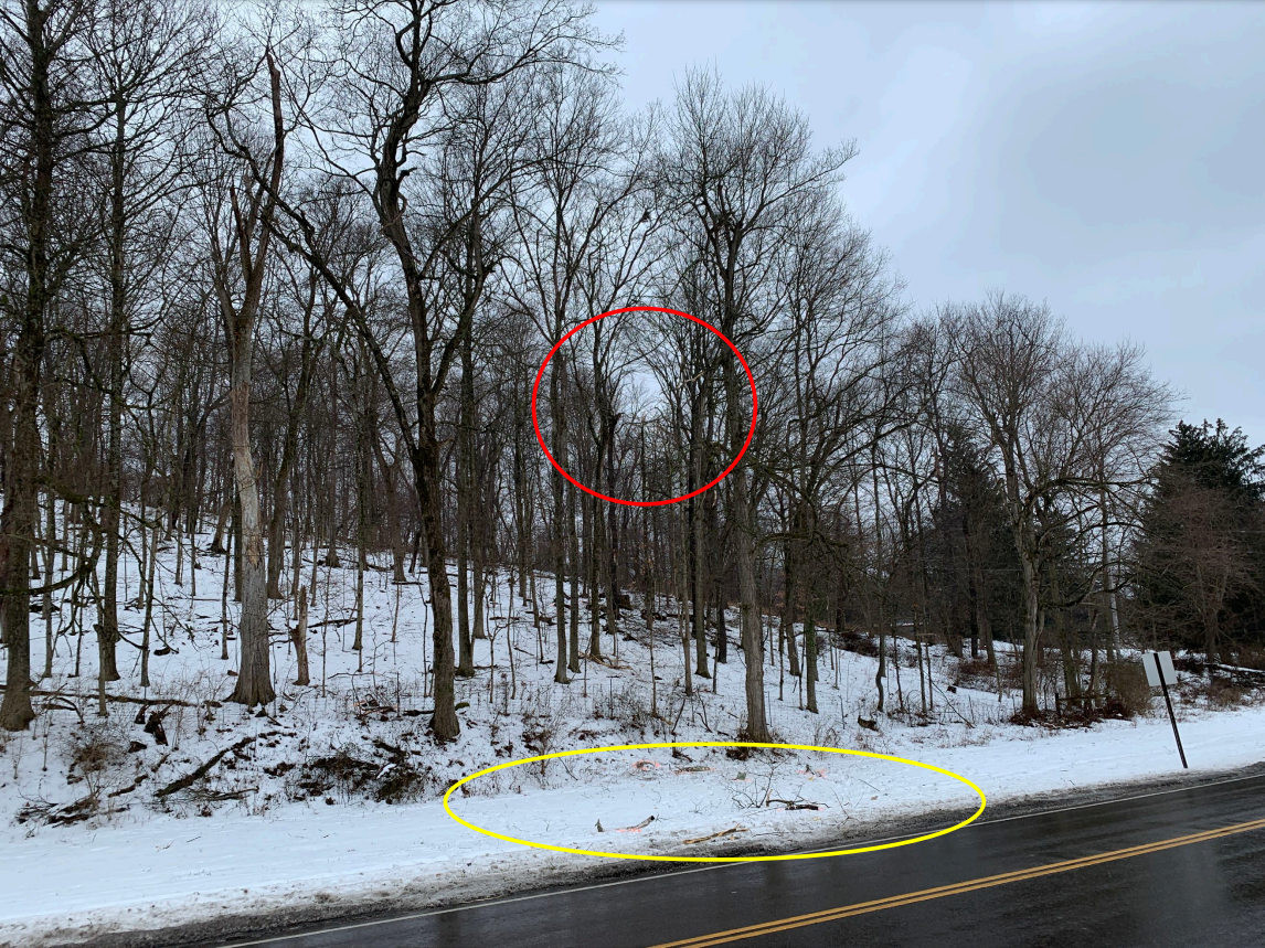
Photo: Debris Field and Initial Impact
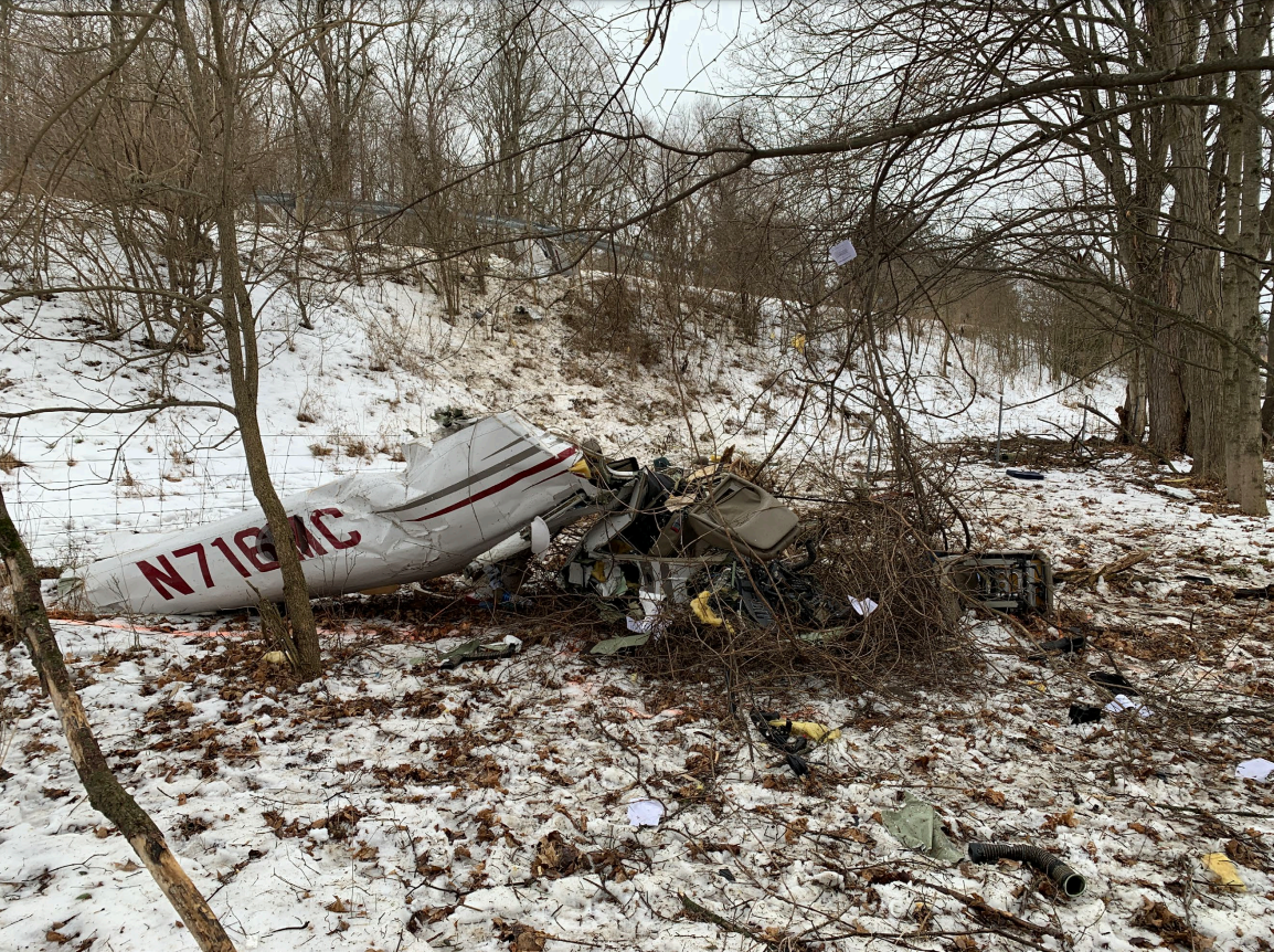
Photos: NTSB
Media:
NTSB is investigating the Feb. 1, 2022, crash of a Cessna 182T airplane near Newark, Ohio.
— NTSB_Newsroom (@NTSB_Newsroom) February 1, 2022
Revision history:
| Date/time | Contributor | Updates |
|---|---|---|
| 02-Feb-2022 00:37 | Geno | Added |
| 02-Feb-2022 03:06 | RobertMB | Updated [Date, Time, Aircraft type, Registration, Cn, Operator, Location, Phase, Nature, Source, Narrative] |
| 02-Feb-2022 04:42 | johnwg | Updated [Time, Departure airport, Destination airport, Narrative, Category] |
| 02-Feb-2022 09:10 | Captain Adam | Updated [Location, Departure airport, Destination airport, Source, Embed code, Narrative] |
| 02-Feb-2022 17:37 | harro | Updated [Embed code, Category] |
| 22-Feb-2022 22:45 | Captain Adam | Updated [Location, Destination airport, Source, Narrative, Category] |
| 23-Feb-2022 07:47 | aaronwk | Updated [Time, Source, Narrative] |
| 04-Mar-2022 22:15 | Captain Adam | Updated [Source, Narrative] |
| 08-Mar-2024 02:03 | Captain Adam | Updated [Phase, Source, Narrative, Accident report, Photo] |
| 08-Mar-2024 02:04 | Captain Adam | Updated [Photo] |
Corrections or additions? ... Edit this accident description
The Aviation Safety Network is an exclusive service provided by:
Quick Links:
| ASN Home | Send Correction / Feedback |
| FSF Home | Disclaimer | Copyright |
| Contact Us | Privacy Policy |
| Press / Media |
 ©2024 Flight Safety Foundation