

ASN Wikibase Occurrence # 277624
This information is added by users of ASN. Neither ASN nor the Flight Safety Foundation are responsible for the completeness or correctness of this information.
If you feel this information is incomplete or incorrect, you can submit corrected information.
| Date: | Saturday 23 April 2022 |
| Time: | 18:48 |
| Type: |  Diamond DA40 Diamond Star |
| Owner/operator: | RRSF LLC |
| Registration: | N321PF |
| MSN: | 40.375 |
| Year of manufacture: | 2004 |
| Total airframe hrs: | 5900 hours |
| Engine model: | Lycoming IO-360-MIA |
| Fatalities: | Fatalities: 4 / Occupants: 4 |
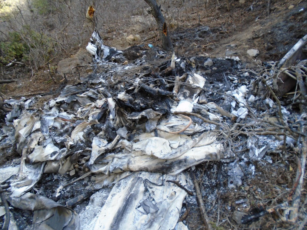
| Aircraft damage: | Destroyed |
| Category: | Accident |
| Location: | near Cedar City, UT -
 United States of America United States of America
|
| Phase: | En route |
| Nature: | Private |
| Departure airport: | Cedar City Airport, UT (CDC/KCDC) |
| Bryce Airport, UT (BCE/KBCE) | |
| Investigating agency: | NTSB |
| Confidence Rating: |
On April 23, 2022, about 1848 mountain daylight time, a Diamond Aircraft, DA 40, N321PF, was destroyed when it was involved in an accident near Cedar City, Utah. The pilot and 3 passengers were fatally injured. The airplane was operated as a Title 14 Code of Federal Regulations Part 91 personal flight.
Witnesses traveling near the accident site reported that they observed the accident airplane flying on an easterly heading about 200 to 300 ft above ground level. The airplane did not appear to be in distress. After the airplane passed over the witnesses’ positions, the airplane maneuvered as if the pilot were trying to turn it around. One witness stated that the airplane’s wings were almost completely vertical at that point. The airplane subsequently impacted mountainous terrain about 7 miles southeast of the departure airport. A postcrash fire ensued.
Postaccident examination of the airplane revealed no evidence of a pre-existing mechanical malfunction that would have precluded normal operation. A review of the airplane’s weight and balance information showed that, at the time of departure, the airplane was about 128 pounds over the airplane’s maximum gross weight of 2,646 pounds. The airplane was also outside the approved center-of-gravity envelope. The calculated density altitude at the time of departure was about 6,022 ft.
The calculated fuel use from the departure airport to the accident location was about 5 gallons. Thus, at the time of the accident, the airplane was likely about 98 pounds over the maximum gross weight. The calculated density altitude at the accident location and the time of the accident was about 7,203 ft. The calculated climb performance for the airplane, at its assumed altitude and air density conditions, would have about 300 ft per minute.
The excessive airplane weight likely limited the airplane’s ability to climb in mountainous terrain.
Probable Cause: The pilot’s failure to maintain obstacle clearance, which resulted in controlled flight into terrain. Contributing to the accident was the pilot’s decision to operate the airplane above its maximum gross weight.
Accident investigation:
 |
|
Sources:
https://www.deseret.com/utah/2022/4/24/23039756/4-dead-in-plane-crash-outside-of-cedar-city-utah-iron-county-officials-say
https://gephardtdaily.com/local/iron-county-sheriff-ids-victims-killed-in-small-plane-utah-county-deputy-wife-among-victims/
https://kslnewsradio.com/1967775/4-die-in-iron-county-plane-crash/
NTSB
https://registry.faa.gov/AircraftInquiry/Search/NNumberResult?nNumberTxt=321PF
https://flightaware.com/live/flight/N321PF/history/20220424/0059Z/KCDC/L%2037.67068%20-113.01857
https://data.ntsb.gov/Docket?ProjectID=104989
https://photos-e1.flightcdn.com/photos/retriever/8431790e851054a17789e7bd5a0e5c83e6b2def1
History of this aircraft
Other occurrences involving this aircraft
| 15 May 2021 | N321PF | Utah Helicopter | 0 | Paris, Idaho | |
sub |
| Heavy landing | ||||||
Location
Images:

Revision history:
| Date/time | Contributor | Updates |
|---|---|---|
| 24-Apr-2022 16:02 | gerard57 | Added |
| 24-Apr-2022 16:20 | RobertMB | Updated [Time, Aircraft type, Location, Source, Embed code, Narrative] |
| 24-Apr-2022 18:43 | johnwg | Updated [Time, Registration, Cn, Operator, Location, Departure airport, Source, Embed code, Narrative, Category] |
| 25-Apr-2022 20:24 | Captain Adam | Updated [Location, Nature, Source, Narrative] |
| 25-Apr-2022 23:37 | johnwg | Updated [Nature, Narrative] |
| 07-May-2022 01:57 | Captain Adam | Updated [Time, Destination airport, Source, Narrative, Category, Photo] |
| 08-May-2022 02:44 | johnwg | Updated [Time, Location, Source, Narrative, Category] |
| 14-Jun-2022 11:03 | Captain Adam | Updated [Time, Location, Source, Narrative, Category] |
Corrections or additions? ... Edit this accident description
The Aviation Safety Network is an exclusive service provided by:
Quick Links:
| ASN Home | Send Correction / Feedback |
| FSF Home | Disclaimer | Copyright |
| Contact Us | Privacy Policy |
| Press / Media |
 ©2024 Flight Safety Foundation