

ASN Wikibase Occurrence # 283674
This information is added by users of ASN. Neither ASN nor the Flight Safety Foundation are responsible for the completeness or correctness of this information.
If you feel this information is incomplete or incorrect, you can submit corrected information.
| Date: | Thursday 22 September 2022 |
| Time: | 14:39 |
| Type: |  Piper PA-28-140 Cherokee |
| Owner/operator: | Private |
| Registration: | N7063R |
| MSN: | 28-21763 |
| Year of manufacture: | 1966 |
| Fatalities: | Fatalities: 1 / Occupants: 1 |
| Aircraft damage: | Destroyed |
| Category: | Accident |
| Location: | Sisters, OR -
 United States of America United States of America
|
| Phase: | En route |
| Nature: | Private |
| Departure airport: | Sisters Eagle Airport, OR (6K5) |
| Curtis Airport, WA (0WA2) | |
| Investigating agency: | NTSB |
| Confidence Rating: |
On September 22, 2022, about 1439 Pacific daylight time, a Piper PA-28-140, N7063R, was destroyed when it was involved in an accident near Sisters, Oregon. The pilot was fatally injured. The airplane was operated as a Title 14 Code of Federal Regulations Part 91 personal flight.
The non-instrument rated pilot departed from California to reposition his airplane to southern Washington. He flew for about 7 hours, which included multiple fuel stops along his route of flight through eastern California and Oregon. Witnesses heard the airplane followed by the impact. One witness reported the engine sounded normal and the other witness reported hearing the engine sound increase before the impact. The impact occurred about 29 minutes after the last en route departure. The wreckage was located on the face of a mountain peak about 20 nautical miles (nm) from the pilot’s last departure airport.
Postaccident examination of the airframe and engine revealed no evidence of mechanical anomalies or malfunctions that could have precluded normal operation. The airplane impacted the ground at a near-vertical, nose-down attitude consistent with an inflight loss of control rather than a controlled flight into terrain.
A friend of the pilot who helped plan the trip reported they checked the weather the day before the departure and the pilot was aware that the weather was not favorable for a direct flight, but the weather would be better if he flew up the east side of the Cascade Mountains.
A review of weather information indicated updrafts and downdrafts from mountain wave development in the area at the accident time. A scattered to broken cloud cover from the ground with tops around 6,000 ft was also present and was corroborated by witness observations at the surface near the accident site, who reported rain, fog and strong wind at the time of the accident. The ceiling forecast was available in the form of graphical weather forecasts that had been issued earlier on the day of the accident. Forecasts indicated instrument meteorological conditions (IMC) prevailed on the pilot’s designated route of flight; however, it is unclear if the pilot received an updated forecast before the flight, or if he received the forecasts and chose to continue the flight regardless.
The pilot had flown for almost seven hours preceding the accident and was likely feeling the effects of physical and mental fatigue which lowers one’s ability to reason and concentrate. Although the data typically used to determine spatial disorientation (SD) was not available for this accident, there is a high probability the pilot was unable to maintain spatial orientation when he encountered IMC, resulting in his subsequent loss of control of the airplane. Contributing to the pilot’s susceptibility to SD was the fatigue he was likely feeling after seven hours of flying, his desire to continue the flight despite evidence indicating that doing so was unsafe, and his lack of an instrument rating.
The limited postmortem toxicological testing detected the volatile substances ethanol, n-butanol, isopropanol, and acetone. Given this combination of substances, as well as the condition and delayed recovery of the pilot’s remains, it is likely that some or all of these detected substances were products of postmortem microbial activity and therefore not considered a factor in this accident.
Probable Cause: The non-instrument-rated pilot’s flight into instrument meteorological conditions, which resulted in spatial disorientation and a subsequent loss of airplane control. Contributing to the accident was the pilot’s degraded judgement due to fatigue.
Accident investigation:
 |
|
Sources:
https://www.q13fox.com/news/us-coast-guard-plane-flying-near-mount-jefferson
https://data.ntsb.gov/Docket?ProjectID=105990
https://registry.faa.gov/AircraftInquiry/Search/NNumberResult?nNumberTxt=N7063R
Location
Images:
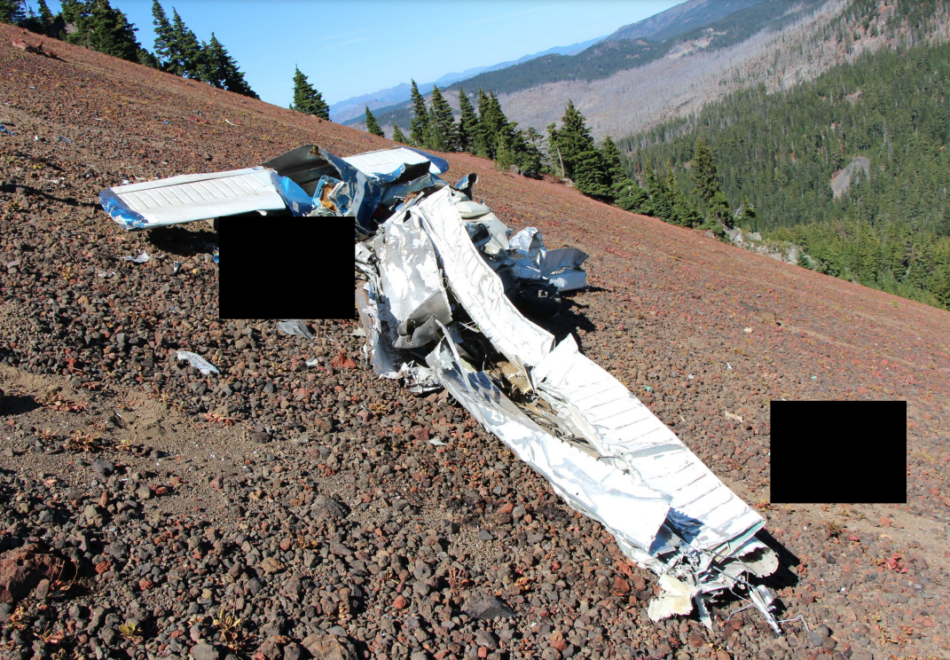
Photo: NTSB
Media:
NTSB investigating the 9/22/2022 crash of a Piper PA28-140 in Sisters, Oregon.
— NTSB Newsroom (@NTSB_Newsroom) September 23, 2022
https://youtu.be/utB9YApOBQc#UPDATE #USCG helicopter aircrew located a plane crash near Mount Jefferson with one deceased person aboard. Our sincerest condolences go out to the friends and family of the individual during this difficult time.
— USCGPacificNorthwest (@USCGPacificNW) September 23, 2022
Revision history:
| Date/time | Contributor | Updates |
|---|---|---|
| 23-Sep-2022 22:39 | Captain Adam | Added |
| 24-Sep-2022 06:34 | gerard57 | Updated [Date, Embed code] |
| 24-Sep-2022 12:09 | RobertMB | Updated [Location, Embed code, Damage, Narrative] |
| 26-Sep-2022 13:44 | RobertMB | Updated [Registration, Cn, Operator, Source, Embed code] |
| 08-Oct-2022 07:17 | Captain Adam | Updated [Time, Location, Departure airport, Destination airport, Source, Narrative, Category] |
| 31-Oct-2022 13:04 | Dogslife4me2003 | Updated [Embed code] |
| 02-May-2024 23:29 | Captain Adam | Updated [Source, Narrative, Accident report, Photo] |
Corrections or additions? ... Edit this accident description
The Aviation Safety Network is an exclusive service provided by:
Quick Links:
| ASN Home | Send Correction / Feedback |
| FSF Home | Disclaimer | Copyright |
| Contact Us | Privacy Policy |
| Press / Media |
 ©2024 Flight Safety Foundation