

ASN Wikibase Occurrence # 305824
This information is added by users of ASN. Neither ASN nor the Flight Safety Foundation are responsible for the completeness or correctness of this information.
If you feel this information is incomplete or incorrect, you can submit corrected information.
| Date: | Thursday 12 January 2023 |
| Time: | 20:17 |
| Type: |  Piper PA-28-180 Cherokee |
| Owner/operator: | Gospel Legacy LLC |
| Registration: | N4254T |
| MSN: | 28-7205121 |
| Year of manufacture: | 1971 |
| Fatalities: | Fatalities: 1 / Occupants: 1 |
| Aircraft damage: | Destroyed |
| Category: | Accident |
| Location: | Dawsonville, GA -
 United States of America United States of America
|
| Phase: | En route |
| Nature: | Private |
| Departure airport: | Cherokee County Regional Airport, GA (KCNI) |
| Stafford-Stafford Regional Airport, VA (KRMN) | |
| Investigating agency: | NTSB |
| Confidence Rating: |
On January 12, 2023, about 2017 eastern standard time, a Piper PA-28-180, N4254T, was destroyed when it was involved in an accident near Dawsonville, Georgia. The pilot was fatally injured. The airplane was operated as a Title 14 Code of Federal Regulations Part 91 personal flight.
The non-instrument-rated private pilot planned to complete a night, visual flight rules (VFR), cross-country flight to return to his home airport. The following day, he had an international flight that he was trying to get back for, in which he would be flying as a passenger. The pilot had questioned airport staff about the weather conditions along his route and they advised the pilot against flying and booked him a hotel to wait until the weather cleared in the morning. The pilot left the airport but returned after the fixed based operator closed; he then used the self-service fuel and departed for his home airport.
Review of automatic dependent surveillance - broadcast (ADS-B) data found that about ten minutes into the flight the flight track began turning left and right and climbing and descending. In the final two minutes of the flight, the airplane entered a series of tight turns and then a rapidly descending spiral turn. The wreckage was located near the final reported ADS-B position.
Examination of the wreckage revealed no preimpact mechanical malfunctions or failures with the airplane. The airplane impacted terrain in a near-vertical descent at a high speed. A witness reported that the airplane descended into terrain in a spinning turn and the engine noise was loud and continuous until impact.
A weather study found that precipitation, convective weather, and clouds were near the departure airport and along the airplane’s flight path. The study found it likely that in the final few minutes of flight the airplane entered an area of light precipitation and clouds and likely did not climb above the cloud layer.
The pilot had not requested a weather briefing for the actual departure time, but he did request a weather briefing for the route departing a few hours earlier. Had the pilot received a weather briefing for the actual departure time, VFR flight would not have been recommended.
Based upon the flight track and meteorological and astronomical data, the pilot initiated a VFR flight into instrument meteorological and dark nighttime conditions. The accident pilot’s flight into instrument meteorological conditions (IMC) likely resulted in his inability to see outside and fly by visual references to the horizon. It is likely the accident pilot was experiencing an increase in workload because of spatial disorientation and was not able to recover from the rapid descending spiral into terrain.
Review of the pilot’s qualifications and experience found that he did not possess an instrument rating, which was required to fly into the conditions experienced, and he had recently received his private pilot certificate about a month and a half prior to the accident. The pilot had about 15 hours of total night experience, and he had never logged actual instrument experience in day or night conditions. This lack of total experience and qualifications to fly in night IMC likely contributed to the pilot’s spatial disorientation and loss of control.
Furthermore, the pilot told the airport staff that he needed to return home the evening of the accident, because the next day he was scheduled to take an international flight to Europe. Despite leaving the airport after he had arrived for the flight and having a hotel room booked for him by the airport staff, he returned later in the evening after the staff had departed, refueled the airplane himself, and took off. The pilot’s aeronautical decision making to depart was likely influenced by his stated desire to get home and make an international flight the next day. According to the FAA Airplane Flying Handbook, this type of influence on decision making can be characterized as “get-home-itis” and is a common external pressure pilots are trained to be cognizant of during preflight.
The pilot’s toxicology report was positive for ethanol. Given that the ethanol was identified at a low level in muscle, but none was found in his liver tissue, most or all of the identified ethanol was likely from sources other than ingestion and did not contribute to the crash.
Probable Cause: The pilot’s decision to initiate a visual flight rules flight into night instrument meteorological conditions, resulting in a loss of control in-flight due to spatial disorientation. Contributing to the accident was the pilot’s lack of qualifications and experience in night instrument meteorological conditions.
Accident investigation:
 |
|
Sources:
https://www.dawsonnews.com/news/public-safety/breaking-one-person-found-dead-following-plane-crash-dawson-forest-wildlife-management-area/
https://data.ntsb.gov/Docket?ProjectID=106575
https://registry.faa.gov/AircraftInquiry/Search/NNumberResult?nNumberTxt=4254T
https://globe.adsbexchange.com/?icao=a51128&lat=34.359&lon=-84.144&zoom=15.0&showTrace=2023-01-13
https://flightaware.com/live/flight/N4254T
https://www.airport-data.com/images/aircraft/001/622/001622122.jpg (photo)
Location
Images:
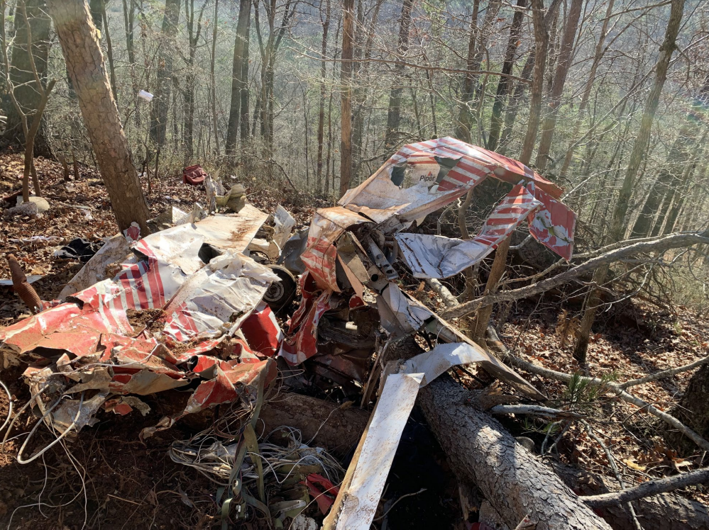
Photo: NTSB
Media:
NTSB is investigating the Jan. 12 crash of a PA-28-180 near Dawsonville, Georgia.
— NTSB Newsroom (@NTSB_Newsroom) January 13, 2023
Revision history:
| Date/time | Contributor | Updates |
|---|---|---|
| 02-May-2024 23:57 | Captain Adam | Updated [Source, Narrative, Accident report, Photo] |
Corrections or additions? ... Edit this accident description
The Aviation Safety Network is an exclusive service provided by:
Quick Links:
| ASN Home | Send Correction / Feedback |
| FSF Home | Disclaimer | Copyright |
| Contact Us | Privacy Policy |
| Press / Media |
 ©2024 Flight Safety Foundation