

ASN Wikibase Occurrence # 45485
This information is added by users of ASN. Neither ASN nor the Flight Safety Foundation are responsible for the completeness or correctness of this information.
If you feel this information is incomplete or incorrect, you can submit corrected information.
| Date: | Tuesday 23 July 2002 |
| Time: | 15:00 |
| Type: |  Piper PA-28-140 Cherokee |
| Owner/operator: | Private |
| Registration: | N8801N |
| MSN: | 28-25646 |
| Year of manufacture: | 1969 |
| Total airframe hrs: | 5000 hours |
| Engine model: | Lycoming O-320-E2A |
| Fatalities: | Fatalities: 1 / Occupants: 1 |
| Aircraft damage: | Destroyed |
| Category: | Accident |
| Location: | Kneeland, CA -
 United States of America United States of America
|
| Phase: | Manoeuvring (airshow, firefighting, ag.ops.) |
| Nature: | Private |
| Departure airport: | Kneeland Airport, CA (O19) |
| Arcata Airport, CA (ACV/KACV) | |
| Investigating agency: | NTSB |
| Confidence Rating: |
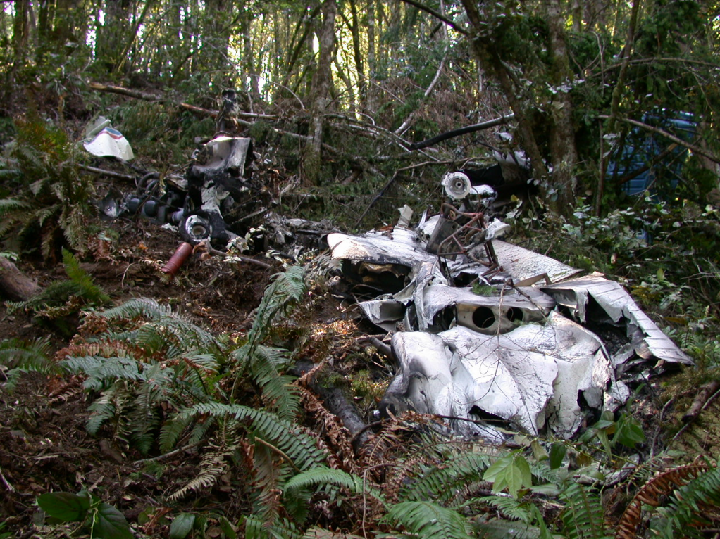
On July 23, 2002, approximately 1500 pacific daylight time, a Piper PA-28-140 single-engine airplane, N8801N, was destroyed when it impacted trees and terrain while maneuvering near Kneeland, California. The airline transport rated pilot, sole occupant of the airplane, sustained fatal injuries. The airplane was registered to the pilot and another private individual. Instrument meteorological conditions prevailed, and an instrument flight rules (IFR) flight plan was filed in-flight for the 14 Code of Federal Regulations Part 91 personal flight. The flight departed the Kneeland Airport (O19), approximately 1420, and was destined for the Arcata Airport (ACV), Arcata, California.
The pilot landed at an airport (elev. 2,737 feet msl), which was located 17.5 nm southeast of his destination airport, prior to proceeding to final destination. While at the forestry facility, the pilot contacted a fellow company pilot, who was located at the destination airport, for a report on the weather conditions. According to various weather reports, at the destination airport (elev. 218 feet msl) the cloud bases were at 1,100 feet agl and cloud tops at 3,000 feet agl. Shortly after departure from the airport, the pilot was cleared by air traffic control (ATC) for an ILS approach to the destination airport's runway 32. For unknown reasons, the pilot cancelled the approach and requested to hold at a fix until he could be cleared for another approach. Approximately 16 minutes later, the pilot was cleared for another ILS approach to runway 32. ATC instructed the pilot to cancel his IFR clearance after landing, the pilot acknowledged the request, and that was the last communication from the pilot to ATC. The airplane impacted several trees, came to rest inverted on a 45-degree sloped ridge, and was destroyed by a post-impact fire. Two separated sections of the left wing were located wrapped around near the tops of 125-foot trees. The wreckage energy path measured approximately 300-feet in length on a measured magnetic heading of 190 degrees. During examination of the wreckage, no aircraft or engine anomalies were noted that would have prevented normal operations.
Probable Cause: The pilot's failure to maintain clearance with the trees while executing an instrument approach. Contributing factors were the clouds and obscuration weather conditions.
Accident investigation:
 |
|
Sources:
NTSB: https://www.ntsb.gov/_layouts/ntsb.aviation/brief.aspx?ev_id=20020731X01271&key=1
Location
Images:
Revision history:
| Date/time | Contributor | Updates |
|---|---|---|
| 28-Oct-2008 00:45 | ASN archive | Added |
| 21-Dec-2016 19:24 | ASN Update Bot | Updated [Time, Damage, Category, Investigating agency] |
| 09-Dec-2017 16:55 | ASN Update Bot | Updated [Destination airport, Source, Narrative] |
| 13-Sep-2023 13:53 | Captain Adam | Updated [[Destination airport, Source, Narrative]] |
Corrections or additions? ... Edit this accident description
The Aviation Safety Network is an exclusive service provided by:
Quick Links:
| ASN Home | Send Correction / Feedback |
| FSF Home | Disclaimer | Copyright |
| Contact Us | Privacy Policy |
| Press / Media |
 ©2024 Flight Safety Foundation