

ASN Wikibase Occurrence # 45915
This information is added by users of ASN. Neither ASN nor the Flight Safety Foundation are responsible for the completeness or correctness of this information.
If you feel this information is incomplete or incorrect, you can submit corrected information.
| Date: | Wednesday 6 June 2001 |
| Time: | 14:30 |
| Type: |  Grumman G-164B Turbo Ag-Cat |
| Owner/operator: | Hicks Farms Inc opb Hoxie Flying Service Inc |
| Registration: | N48721 |
| MSN: | 122B |
| Year of manufacture: | 1976 |
| Total airframe hrs: | 8726 hours |
| Engine model: | Garrett TPE-331-1-15A |
| Fatalities: | Fatalities: 1 / Occupants: 1 |
| Aircraft damage: | Destroyed |
| Category: | Accident |
| Location: | Powhatan, AR -
 United States of America United States of America
|
| Phase: | Manoeuvring (airshow, firefighting, ag.ops.) |
| Nature: | Agricultural |
| Departure airport: | Cavenaugh Farm staging strip, AR |
| Investigating agency: | NTSB |
| Confidence Rating: |
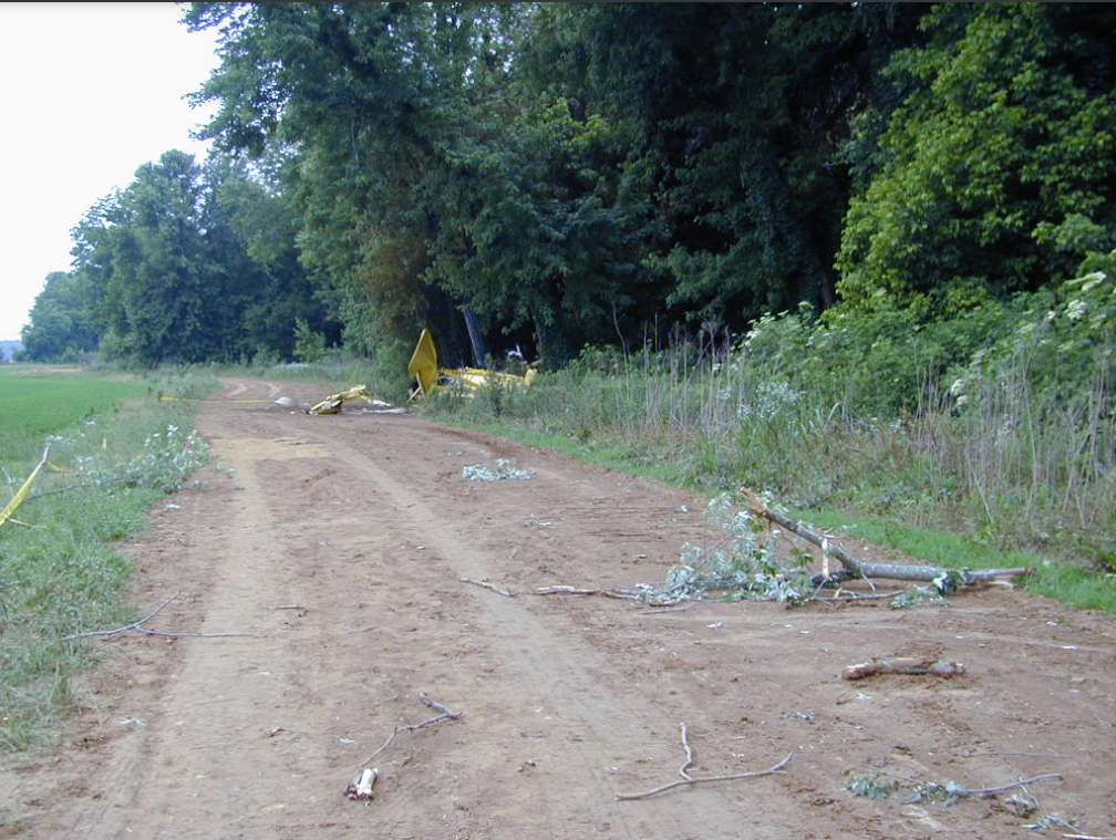
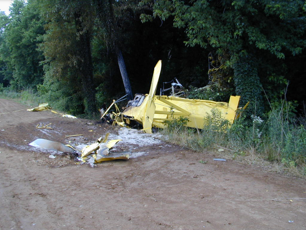
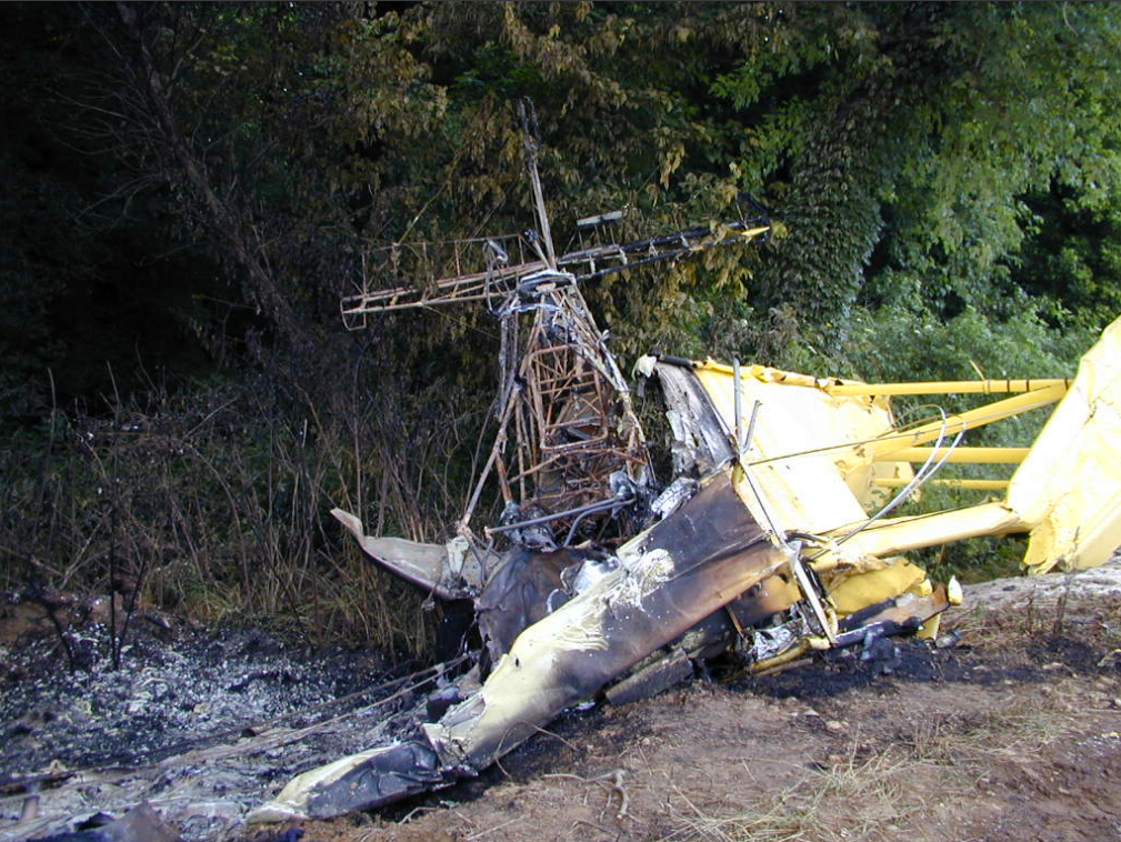
On June 6, 2001, approximately 1430 central daylight time, a Grumman-Schweizer G-164B agricultural airplane, N48721, was destroyed when it impacted terrain while maneuvering after takeoff near Powhatan, Arkansas. The airplane was registered to Hicks Farms, Inc. and operated by Hoxie Flying Service, both of Walnut Ridge, Arkansas. The commercial pilot, sole occupant of the airplane, was fatally injured. Visual meteorological conditions prevailed, and a flight plan was not filed for the 14 Code of Federal Regulations Part 137 aerial application flight. The local flight was originating from the Cavenaugh Farm staging strip, Powhatan, when the accident occurred.
Prior to departing for the 10 minute flight from the base of operation to the staging strip, the agricultural airplane's fuel tanks were topped off. After arriving at the staging strip, the airplane was loaded with 2,300 pounds of fertilizer. The airplane took off from the 2,900-foot dirt strip to the west with a right quartering tailwind (3-4 knots). After takeoff, while the airplane was turning left, its left wing struck trees. Subsequently, the airplane impacted the ground in a near inverted, nose low attitude, approximately 3,900 feet from the east end of the air strip. The airplane came to rest upright and was consumed by the ensuing fire. A witness reported observing the accident airplane as it was taking off to the west; however, he did not witness the accident. The witness reported that "the only thing that might have been odd about the takeoff was a slightly longer than normal [roll] out before he broke ground. But not enough concern for me to turn and watch his departure [to the] south." The operator reported that the normal south departure procedure when taking off west was to turn south prior to the trees and go under a set of power lines. The FAA inspector who examined the airplane wreckage, established flight control continuity. An autopsy on the pilot did not reveal evidence of any preexisting disease that could have contributed to the accident, and toxicological tests were negative for carbon monoxide, cyanide, alcohol, and drugs.
Probable Cause: The pilot's failure to maintain obstacle clearance while maneuvering after takeoff.
Accident investigation:
 |
|
Sources:
NTSB: https://www.ntsb.gov/_layouts/ntsb.aviation/brief.aspx?ev_id=20010607X01093&key=1
Images:
Photos: NTSB
Revision history:
| Date/time | Contributor | Updates |
|---|---|---|
| 28-Oct-2008 00:45 | ASN archive | Added |
| 21-Dec-2016 19:24 | ASN Update Bot | Updated [Time, Damage, Category, Investigating agency] |
| 10-Dec-2017 11:27 | ASN Update Bot | Updated [Operator, Departure airport, Source, Narrative] |
Corrections or additions? ... Edit this accident description
The Aviation Safety Network is an exclusive service provided by:
Quick Links:
| ASN Home | Send Correction / Feedback |
| FSF Home | Disclaimer | Copyright |
| Contact Us | Privacy Policy |
| Press / Media |
 ©2024 Flight Safety Foundation