

ASN Wikibase Occurrence # 65992
This information is added by users of ASN. Neither ASN nor the Flight Safety Foundation are responsible for the completeness or correctness of this information.
If you feel this information is incomplete or incorrect, you can submit corrected information.
| Date: | Monday 17 November 2008 |
| Time: | 17:03 |
| Type: |  Piper PA-38-112 Tomahawk |
| Owner/operator: | Private |
| Registration: | N2316P |
| MSN: | 38-79A0942 |
| Year of manufacture: | 1979 |
| Engine model: | Lycoming O-235-L2C |
| Fatalities: | Fatalities: 2 / Occupants: 2 |
| Aircraft damage: | Substantial |
| Category: | Accident |
| Location: | Pawtucket-North Central State Airport, RI (SFZ) -
 United States of America United States of America
|
| Phase: | Approach |
| Nature: | Private |
| Departure airport: | Providence, RI (PVD) |
| Smithfield, RI (SFZ) | |
| Investigating agency: | NTSB |
| Confidence Rating: |
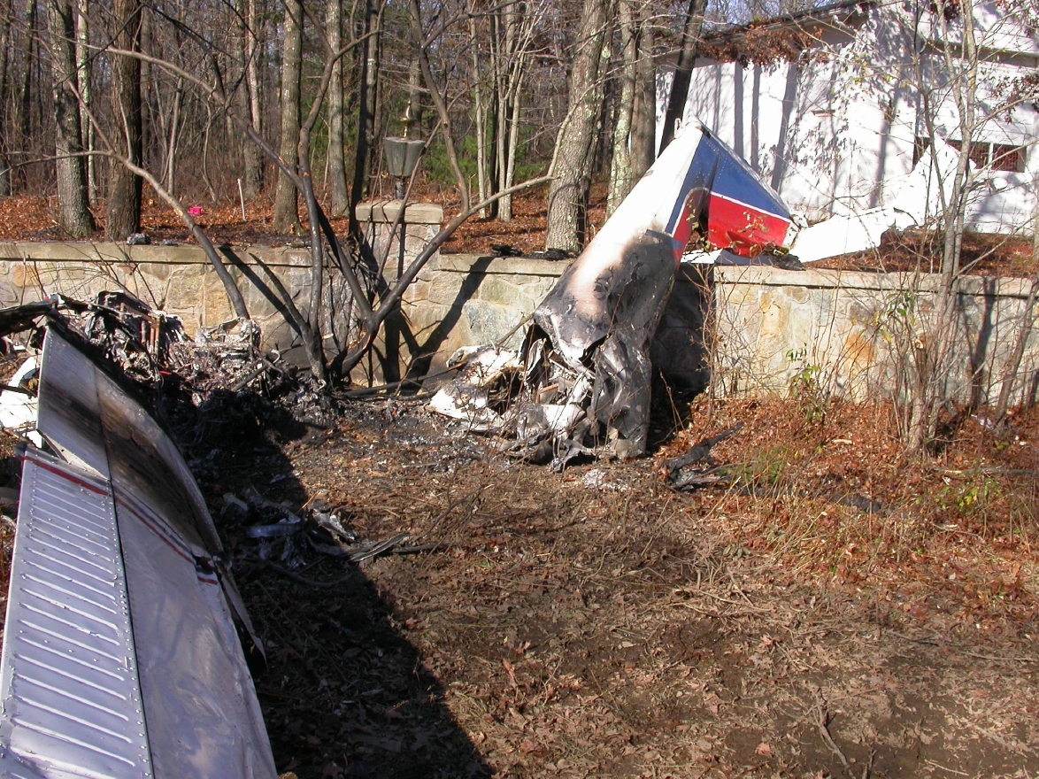
The airplane approached the airport in night visual meteorological conditions, with an instrument-rated private pilot and a private-pilot-rated passenger. The pilot received clearance for a practice very-high-omnidirectional-range/global-positioning-system approach. At 1,900 feet mean sea level (msl) and prior to the final approach fix (FAF), the pilot was cleared for the practice approach and a frequency change was approved. There was no further communication with the accident flight. Radar data showed the accident flight on a ground track associated with the approach and in a steady descent from the FAF to 500 feet msl, or 80 feet above ground level (agl) and near the first tree strike. The accident occurred approximately 2/3 mile from the threshold of runway 33. The airplane was on the correct ground track for the approach when it initially struck trees approximately 80 feet agl. The minimum descent altitude for the approach was 980 feet msl, or 539 feet agl. No evidence of any preimpact mechanical discrepancies were found with the airframe or engine that would have prevented a successful completion of the approach. Recorded weather conditions at the airport near the time of the accident included a broken cloud layer at 8,000 feet, surface visibility 10 statute miles, and a surface wind from the northwest at 6 knots.
Probable Cause: The pilot's improper descent below the published minimum descent altitude during the approach, which resulted in controlled flight into terrain.
Accident investigation:
 |
|
Sources:
NTSB
FAA register: 2. FAA: http://registry.faa.gov/aircraftinquiry/NNum_Results.aspx?NNumbertxt=2316P
Location
Images:
(c) NTSB
Revision history:
| Date/time | Contributor | Updates |
|---|---|---|
| 27-Jun-2009 00:30 | harro | Added |
| 13-Feb-2016 22:04 | Dr.John Smith | Updated [Operator, Source, Narrative] |
| 13-Feb-2016 22:05 | Dr.John Smith | Updated [Time, Narrative] |
| 21-Dec-2016 19:25 | ASN Update Bot | Updated [Time, Damage, Category, Investigating agency] |
| 03-Dec-2017 12:11 | ASN Update Bot | Updated [Operator, Other fatalities, Departure airport, Destination airport, Source, Narrative] |
Corrections or additions? ... Edit this accident description
The Aviation Safety Network is an exclusive service provided by:
Quick Links:
| ASN Home | Send Correction / Feedback |
| FSF Home | Disclaimer | Copyright |
| Contact Us | Privacy Policy |
| Press / Media |
 ©2024 Flight Safety Foundation