

ASN Wikibase Occurrence # 71071
This information is added by users of ASN. Neither ASN nor the Flight Safety Foundation are responsible for the completeness or correctness of this information.
If you feel this information is incomplete or incorrect, you can submit corrected information.
| Date: | Tuesday 5 January 2010 |
| Time: | 12:09 |
| Type: |  Bell 206B-3 JetRanger III |
| Owner/operator: | California Department of Fish & Game |
| Registration: | N5016U |
| MSN: | 2634 |
| Year of manufacture: | 1979 |
| Total airframe hrs: | 15379 hours |
| Engine model: | Rolls-Royce 250-C20J |
| Fatalities: | Fatalities: 4 / Occupants: 4 |
| Aircraft damage: | Substantial |
| Category: | Accident |
| Location: | Near Redinger Lake, California -
 United States of America United States of America
|
| Phase: | En route |
| Nature: | Survey |
| Departure airport: | Trimmer, CA |
| Trimmer, CA | |
| Investigating agency: | NTSB |
| Confidence Rating: |
The pilot was flying a deer-surveying mission under contract with a state government agency with three state employees onboard. About 2 hours into the flight, witnesses observed the helicopter flying along a valley and colliding with one of two “skylines,” or cables strung between the towers of power transmission lines. The transmission lines consisted of two parallel steel skylines on top and three power conductor lines mounted about 20 feet below. The helicopter appeared to be flying straight and level prior to the collision, exhibiting no indications of distress. Examination of the engine and damage to the rotor system indicated that the engine was producing power at the time of the collision. Examination of the airframe and engine did not reveal any evidence of preaccident failure or malfunction. The transmission lines were depicted on the applicable sectional map, as well as a printed survey map located in the debris field. The power conductor lines were observed to sag about 70 feet below the skyline in the area of the accident. The power conductor lines were about twice as thick as the skyline. Additionally, the position of the sun would have hindered identification of the skyline by the pilot. In the area of the collision a second set of power lines were located about 200 feet below the lines depicted on the maps. As such, it is possible that the pilot misidentified these as the lines depicted on the maps. Neither of the sets of power lines were equipped with spherical visibility markers or similar identification devices.
The helicopter was equipped with a wire strike protection system; however, examination of its cutting surfaces revealed that it did not make contact with any lines. The helicopter struck the second skyline along the direction of flight, indicating that it flew below the first line with the main rotor blades striking the second line from below; since the wire struck outside of the cutters’ capture envelope, the wire strike protection system would not have been in a position to protect the helicopter. Federal regulations require that any planned construction of structures over 200 feet above ground level (agl) be filed with the Federal Aviation Administration. While the power lines’ height exceeds 200 feet agl at the center of the span, their construction predates adoption of the regulation. At the time of the accident, the state agency did not have any formal safety or operational training systems in place for passengers who fly on surveying missions.
Probable Cause: The pilot's failure to see and avoid a wire while maneuvering during low-altitude operations.
Accident investigation:
 |
|
Sources:
NTSB
Location
Images:
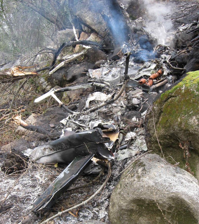
Photo: NTSB
Revision history:
| Date/time | Contributor | Updates |
|---|---|---|
| 05-Jan-2010 22:27 | slowkid | Added |
| 05-Jan-2010 22:30 | slowkid | Updated [Source, Narrative] |
| 05-Jan-2010 23:32 | angels one five | Updated [Operator, Nature, Narrative] |
| 06-Jan-2010 07:15 | emil | Updated [Registration, Cn] |
| 06-Jan-2010 12:38 | RobertMB | Updated [Aircraft type, Operator] |
| 21-Dec-2016 19:25 | ASN Update Bot | Updated [Time, Damage, Category, Investigating agency] |
| 26-Nov-2017 12:31 | ASN Update Bot | Updated [Operator, Other fatalities, Nature, Departure airport, Destination airport, Source, Narrative] |
| 26-Nov-2017 16:08 | harro | Updated [Nature, Photo, ] |
| 29-May-2023 21:20 | Ron Averes | Updated [[Nature, Photo, ]] |
Corrections or additions? ... Edit this accident description
The Aviation Safety Network is an exclusive service provided by:
Quick Links:
| ASN Home | Send Correction / Feedback |
| FSF Home | Disclaimer | Copyright |
| Contact Us | Privacy Policy |
| Press / Media |
 ©2024 Flight Safety Foundation