

ASN Wikibase Occurrence # 74417
This information is added by users of ASN. Neither ASN nor the Flight Safety Foundation are responsible for the completeness or correctness of this information.
If you feel this information is incomplete or incorrect, you can submit corrected information.
| Date: | Tuesday 6 May 1969 |
| Time: | 19:35 |
| Type: |  Aero Commander 500S Shrike Commander |
| Owner/operator: | Executive Air Services Pty Ltd. |
| Registration: | VH-EXT |
| MSN: | |
| Fatalities: | Fatalities: 0 / Occupants: 3 |
| Aircraft damage: | Destroyed |
| Category: | Accident |
| Location: | 2 miles W of Warracknabeal Aerodrome, VIC -
 Australia Australia
|
| Phase: | Approach |
| Nature: | Passenger - Scheduled |
| Departure airport: | Essendon, Melbourne (MEB/YMEN) |
| Warracknabeal Airport (WKB/YWKB) | |
| Investigating agency: | BASI |
| Confidence Rating: |
At approximately 1935 hours EST on 6 May, 1969 an Aero Commander 500S aircraft, registered VH-EXT, struck the ground and crashed 2 miles west of Warracknabeal Aerodrome, Victoria, while making an approach to land at that aerodrome.
The aircraft was owned and operated by Executive Air Services Pty. Ltd. of Melbourne. and at the time of the accident it was engaged on a scheduled passenger commuter service between Essendon and Warracknabeal.
After entering the circuit the pilot commenced a downwind leg for a landing towards the east on runway 08. He made a left turn onto base leg and noted the indicated altitude as 1,000 feet, and at that altitude, the clearance between the aircraft and the local terrain should have been slightly more than 600 feet. On the base leg of the circuit, the pilot was unable to see the runway lights and being unsure of his position, he elected to conduct a go around.
He did not retract the undercarriage, which had been extended earlier in preparation for landing, and the pilot continued the second circuit at 1,000 feet indicated altitude rather than climbing to establish 1,000 feet terrain clearance which would have been the normal procedure. He flew over the non-directional beacon, which is located approximately 300 yards north of the western end of the runway on which he intended to land arid he then positioned the aircraft for the downwind leg of the circuit.
The pilot, Allan James WALKER, and one passenger received minor injuries. A second passenger, the only other occupant, was seriously injured. The aircraft was virtually destroyed by impact forces.
When removed from the wreckage, both altimeters gave erroneous readings. Detailed examination of the instruments indicated that each had been capable of normal operation prior to the accident and that the subsequent inaccuracies were the result of impact damage.
ATSB Conclusion: The probable cause of the accident was that the pilot, in approaching an aerodrome at night, did not use appropriate circuit procedures and did not make full use of the available visual and instrument information to ensure adequate terrain clearance.
Accident investigation:
 |
|
Sources:
1. http://www.atsb.gov.au/publications/investigation_reports/1969/aair/aair196902357.aspx
2. https://sites.google.com/site/aerocommanderproductionlist/
Images:
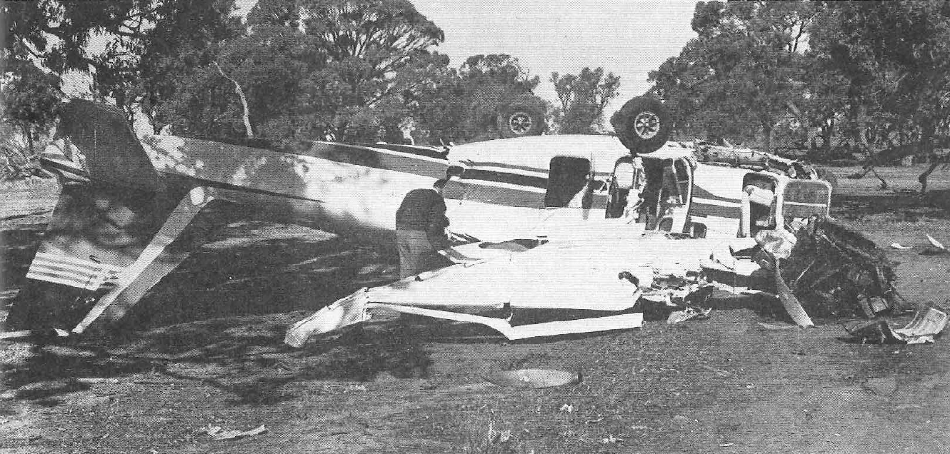
Photo: BASI
Revision history:
| Date/time | Contributor | Updates |
|---|---|---|
| 20-May-2010 11:05 | Petro | Added |
| 05-Apr-2014 19:18 | Dr. John Smith | Updated [Date, Time, Aircraft type, Registration, Operator, Total occupants, Location, Phase, Nature, Departure airport, Destination airport, Source, Narrative] |
| 05-Apr-2014 19:19 | Dr. John Smith | Updated [Narrative] |
| 19-Nov-2014 23:52 | Dr. John Smith | Updated [Destination airport] |
| 11-Nov-2018 13:38 | harro | Updated [Photo, Accident report, ] |
| 10-Jun-2022 02:41 | Ron Averes | Updated [Location] |
Corrections or additions? ... Edit this accident description
The Aviation Safety Network is an exclusive service provided by:
Quick Links:
| ASN Home | Send Correction / Feedback |
| FSF Home | Disclaimer | Copyright |
| Contact Us | Privacy Policy |
| Press / Media |
 ©2024 Flight Safety Foundation