

ASN Wikibase Occurrence # 191909
This information is added by users of ASN. Neither ASN nor the Flight Safety Foundation are responsible for the completeness or correctness of this information.
If you feel this information is incomplete or incorrect, you can submit corrected information.
| Date: | Wednesday 7 December 2016 |
| Time: | 10:43 |
| Type: |  Bellanca 7GCBC |
| Owner/operator: | Private |
| Registration: | N88452 |
| MSN: | 787-75 |
| Year of manufacture: | 1974 |
| Total airframe hrs: | 2889 hours |
| Engine model: | Lycoming O-320-A2D |
| Fatalities: | Fatalities: 1 / Occupants: 1 |
| Aircraft damage: | Substantial |
| Category: | Accident |
| Location: | Fort Wainright, Fairbanks Metropolitan Statiscal Area, AK -
 United States of America United States of America
|
| Phase: | Manoeuvring (airshow, firefighting, ag.ops.) |
| Nature: | Test |
| Departure airport: | Fairbanks, AK (AK28) |
| Fairbanks, AK (AK28) | |
| Investigating agency: | NTSB |
| Confidence Rating: |
The airline transport pilot was conducting a post-maintenance test flight following the installation of vortex generators (VGs) on the airplane's wings and horizontal stabilizers. The GPS track data were consistent with the performance of level turns, slow flight, and stalls. The last 2.5 minutes of the flight exhibited a decelerating, descending profile consistent with performance of a power off stall; during this time, the airplane descended from 1,033 ft above ground level (agl) to 469 ft agl and slowed from 81 knots to 26 knots. At 26 knots, an abrupt loss of control occurred as indicated by a sharp right turn and a rapid descent rate of about 2,000 ft per minute (fpm). During the 30 seconds before the rapid descent began, the airplane had a rate of descent of about 500 fpm. The last valid GPS data point showed an increasing groundspeed of 35 knots and an altitude of 75 ft agl. Examination of the accident site indicated that the airplane impacted trees and traveled about 350 ft before coming to rest upright.
Examination of the wreckage did not reveal evidence of any preimpact mechanical malfunctions or anomalies that would have precluded normal operation. The GPS data and site examination indicated that the pilot likely lost control of the airplane while performing a full flap aerodynamic stall and was recovering from the maneuver when the airplane impacted trees.
According to the GPS data, the pilot initiated the practice stall sequence about 500 ft below the FAA-recommended minimum practice stall recovery altitude of 1,500 ft agl. As a result, the pilot had insufficient altitude to safely recover from the maneuver before the airplane impacted terrain.
According to the manufacturer of the VGs, the airplane's expected full flap stall speed was about 33 knots, which was 7 knots higher than the speed at which the loss of control event occurred. Based on the GPS data, the airplane reached 33 knots about 30 seconds before the loss of control and likely entered a stalled condition at that time; however, the pilot apparently failed to recognize the stall and allowed the descent to continue. It is possible that the improved aileron authority at slow airspeeds, which the VG installation provided, allowed the pilot to maintain aileron control while the airplane was in a stalled condition. Further, according to the manufacturer's test data, the pre-modified airplane would have had a pronounced wing drop at the onset of stall. The stall characteristics of the modified airplane likely contributed to the pilot's failure to recognize that the airplane was stalled.
The supplemental type certificate (STC) for the VGs directed the installer to determine compatibility with other STCs, and the installation manual for the VGs stated that STC compatibility may be accomplished by a flight test consisting of a "subjective evaluation of aircraft handling to determine that no adverse characteristics exist." The pilot was conducting this flight test flight when the accident occurred. However, there was no guidance in the installation manual on what characteristics a pilot should expect from a modified airplane or how to conduct such a compatibility test. If such guidance had been available, the pilot may have selected an appropriate altitude for the test and may have recognized and recovered from the stall before losing excessive altitude.
The sun's azimuth at the time of the accident was 134° magnetic and slightly above the horizon. The final track of the airplane started at 133° and varied from 111° to 136°, which indicated that the pilot was looking into the sun during the final leg of the flight. The snow-covered ground would have reflected more sun rays into the pilot's eyes, which may have increased the effects of sun glare. It is likely that sun glare impaired the pilot's ability to see the flight instruments and the terrain.
Probable Cause: The pilot's operation of the airplane at an altitude that was too low to allow for recovery from an intentional aerodynamic stall, which resulted in an impact with terrain. Contributing to the accident were the pilot's inability to recognize altitude deviations during slow flight due to the sun glare and the pilot's lack of knowledge of the stall performance characteristics of the airplane modified with vortex generators due to the lack of information from the manufacturer.
Accident investigation:
 |
|
Sources:
NTSB
FAA register: http://registry.faa.gov/aircraftinquiry/NNum_Results.aspx?NNumbertxt=N88452
Location
Images:
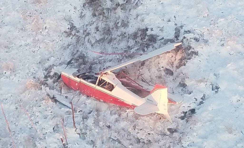
Photo: NTSB
Revision history:
| Date/time | Contributor | Updates |
|---|---|---|
| 08-Dec-2016 03:14 | Geno | Added |
| 08-Dec-2016 16:34 | Geno | Updated [Aircraft type, Registration, Cn, Operator, Source] |
| 22-Aug-2018 10:37 | ASN Update Bot | Updated [Time, Nature, Departure airport, Destination airport, Source, Damage, Narrative] |
| 22-Aug-2018 11:10 | harro | Updated [Phase, Nature, Source, Narrative, Photo, ] |
Corrections or additions? ... Edit this accident description
The Aviation Safety Network is an exclusive service provided by:
Quick Links:
| ASN Home | Send Correction / Feedback |
| FSF Home | Disclaimer | Copyright |
| Contact Us | Privacy Policy |
| Press / Media |
 ©2024 Flight Safety Foundation