

| Date: | Wednesday 27 March 1968 |
| Time: | 17:57 |
| Type: |  Douglas DC-9-15 |
| Owner/operator: | Ozark Air Lines |
| Registration: | N970Z |
| MSN: | 45772/30 |
| Year of manufacture: | 1966 |
| Total airframe hrs: | 5172 hours |
| Engine model: | Pratt & Whitney JT8D-7B |
| Fatalities: | Fatalities: 0 / Occupants: 49 |
| Other fatalities: | 2 |
| Aircraft damage: | Substantial, repaired |
| Category: | Accident |
| Location: | 2,4 km N of Saint Louis-Lambert International Airport, MO (STL) -
 United States of America United States of America
|
| Phase: | Approach |
| Nature: | Passenger - Scheduled |
| Departure airport: | Peoria-Greater Peoria Airport, IL (PIA/KPIA) |
| Saint Louis-Lambert International Airport, MO (STL/KSTL) | |
| Investigating agency: | NTSB |
| Confidence Rating: |
An Ozark Air Lines DC-9, N970Z, and an Interstate Airmotive Cessna l5OF (N8669G) collided in flight approximately 1.5 miles north of Lambert Field, St. Louis, Missouri, at approximately 17:57 local time.
Both aircraft were in the landing pattern for Runway 17, under the jurisdiction of the St. Louis Tower, when the accident occurred.
The Cessna was demolished by the collision and ground impact, and both occupants were fatally injured. The DC-9 sustained light damage and was able to effect a safe landing.
PROBABLE CAUSE: "The combination of: the inadequacy of current VFR separation standards in controlled airspace, the crew of the DC-9 not sighting the Cessna in time to avoid it, the absence of VFR traffic pattern procedures to enhance an orderly flow of landing aircraft, the local controller not assuring that important landing information issued to the Cessna was received and understood under the circumstances of a heavy traffic situation without radar assistance, and the Cessna crew's deviation from their traffic pattern instructions and/or their continuation to a critical point in the traffic pattern without informing the local controller of the progress of the flight."
Accident investigation:
 |
|
Sources:
Images:
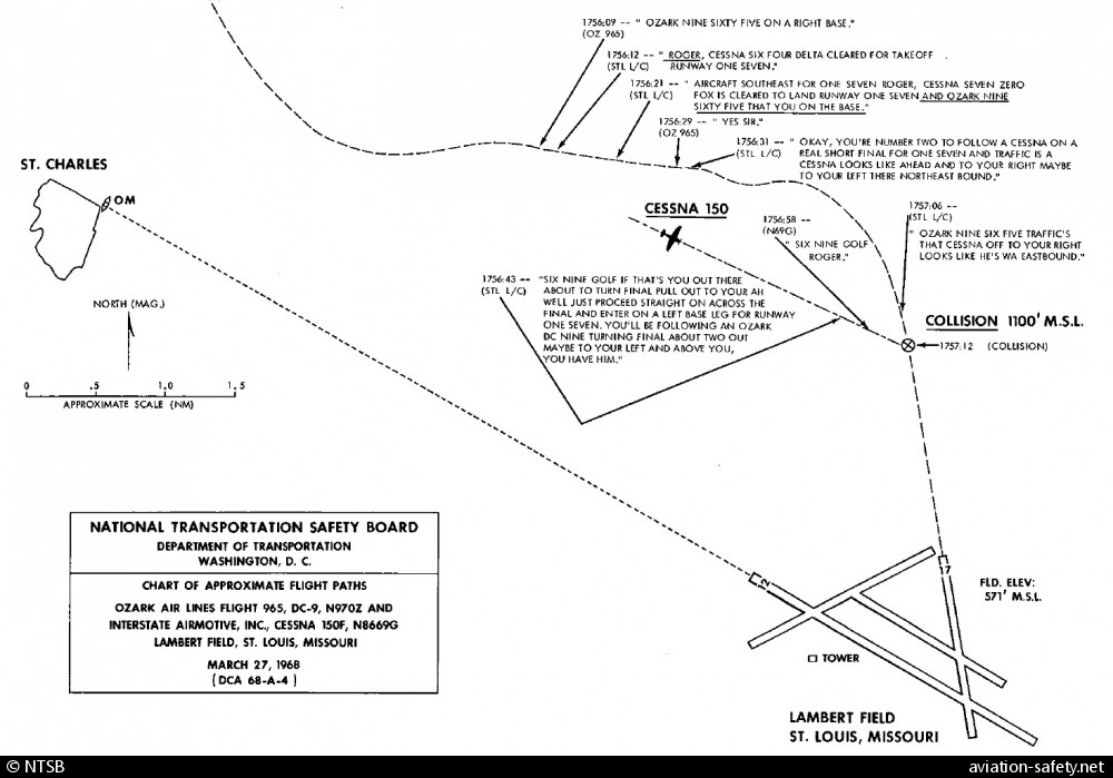
photo (c) NTSB; near Saint Louis-Lambert International Airport, MO (STL); 27 March 1968
Revision history:
| Date/time | Contributor | Updates |
|---|
The Aviation Safety Network is an exclusive service provided by:
Quick Links:
| ASN Home | Send Correction / Feedback |
| FSF Home | Disclaimer | Copyright |
| Contact Us | Privacy Policy |
| Press / Media |
 ©2024 Flight Safety Foundation