

| Date: | Friday 2 October 2015 |
| Time: | 14:49 |
| Type: |  de Havilland Canada DHC-6 Twin Otter 300 |
| Owner/operator: | Aviastar Mandiri |
| Registration: | PK-BRM |
| MSN: | 741 |
| Year of manufacture: | 1981 |
| Total airframe hrs: | 45242 hours |
| Cycles: | 75241 flights |
| Engine model: | Pratt & Whitney Canada PT6A-27 |
| Fatalities: | Fatalities: 10 / Occupants: 10 |
| Aircraft damage: | Destroyed, written off |
| Category: | Accident |
| Location: | Bajaja Mount, District of Luwu, South Sulawesi -
 Indonesia Indonesia
|
| Phase: | En route |
| Nature: | Passenger - Scheduled |
| Departure airport: | Masamba/Andi Jemma Airport (MXB/WAWM) |
| Makassar-Sultan Hasanuddin International Airport (UPG/WAAA) | |
| Investigating agency: | NTSC |
| Confidence Rating: |
The DHC-6 Twin Otter, registered PK-BRM was being operated by Aviastar Mandiri as a scheduled passenger flight with flight number MV7503. The aircraft departed from Masamba/Andi Jemma Airport intended destination to Makassar-Sultan Hasanuddin International Airport on the island of South Sulawesi in Indonesia.
The pilot-in-command acted as Pilot Flying while the second-in-command acted as pilot monitoring.
According to the flight plan clearance issued by Andi Jemma Airport Air Traffic Information Service (ATIS) the pilot intended to fly VFR with altitude of 8000 feet and fly a direct route from Masamba to Makassar.
The aircraft departed from Masamba at 06:25 UTC (14:25 LT) and estimated time of arrival Makassar at 07:39 UTC.
A partial cloud formation was present at about 60 nautical miles from Masamba on the direct track to Makassar around Mount Bajaja and Mount Latimojong.
At 06:36 UTC, the pilot informed the Ujung Pandang Information officer that the aircraft had reached 8,000 feet. One minute later the pilots discussed to fly direct to Barru from their current position. Barru is a town located at about 45 Nm north of Makassar. Both pilots agreed to fly direct and the second-in-command (SIC) explained the experience of flying direct on the flight before. A few seconds later the SIC suggested to delay the direct flight for a while. At 06:50 UTC, the PIC told the SIC that he wanted to climb and the CVR stopped recording. The aircraft impacted treetops and crashed on the top of a mountain at an elevation of 7734 feet.
The wreckage was located on Bajaja Mount on October 5.
Contributing Factors: "Deviation from the company visual route without properly considering the elevated risks of cruising altitude lower than the highest terrain and instrument meteorological condition in addition with the absence of the EGPWS warning resulted in the omission of avoidance actions."
Accident investigation:
 |
|
Sources:
Location
Images:
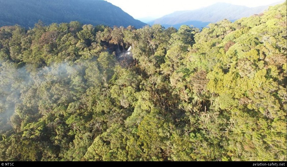
photo (c) NTSC; Mount Latimojong; October 2015

photo (c) NTSC; Mount Latimojong; October 2015
Revision history:
| Date/time | Contributor | Updates |
|---|
The Aviation Safety Network is an exclusive service provided by:
Quick Links:
| ASN Home | Send Correction / Feedback |
| FSF Home | Disclaimer | Copyright |
| Contact Us | Privacy Policy |
| Press / Media |
 ©2024 Flight Safety Foundation