

ASN Wikibase Occurrence # 121258
This information is added by users of ASN. Neither ASN nor the Flight Safety Foundation are responsible for the completeness or correctness of this information.
If you feel this information is incomplete or incorrect, you can submit corrected information.
| Date: | Monday 21 March 2011 |
| Time: | 21:18 |
| Type: |  Cessna F152 (Reims) |
| Owner/operator: | Westair Flying Services Ltd |
| Registration: | G-BJKY |
| MSN: | F152-1886 |
| Year of manufacture: | 1981 |
| Engine model: | Lycoming O-235-L2C |
| Fatalities: | Fatalities: 0 / Occupants: 2 |
| Aircraft damage: | Destroyed |
| Category: | Accident |
| Location: | Ingleborough Moor, near Settle, North Yorkshire -
 United Kingdom United Kingdom
|
| Phase: | En route |
| Nature: | Training |
| Departure airport: | Blackpool, Lancashire (BLK/EGLK) |
| Blackpool, Lancashire (BLK/EGNH) | |
| Investigating agency: | AAIB |
| Confidence Rating: |
The aircraft departed Blackpool Airport in good visibility. The instructor reported that the first three planned legs of the exercise were completed satisfactorily and, during the leg to Clitheroe, he told the student that after Clitheroe he would like him to divert to Kirkby Lonsdale, a town which was often used by the flying school as a turning point during PPL VFR navigation training. The student plotted the diversion leg on his chart, calculated the wind-corrected heading and time for the diversion leg and successfully identified Clitheroe. He then turned the aircraft onto the heading for Kirkby Lonsdale and climbed to the calculated safe altitude. The instructor could not recall the heading that the student had selected or the exact altitude flown but believed the latter was either 2,800 or 3,000 feet amsl.
The instructor reported that, initially, the student had some difficulty maintaining the intended heading but subsequently managed to regain it. He also stated that they could see nothing, describing the leg from Clitheroe as a “black hole”. He could not ascertain whether this was because they were in cloud. To back up their visual and dead-reckoning navigation, the instructor used the aircraft’s single navigation receiver to obtain bearings from the Wallasey (WAL) and Pole Hill (POL) VORs, to the south-west and south-east of the aircraft respectively.
From these bearings, which were not plotted on the chart, he concluded that the aircraft was slightly to the right (east) of track. He reported that there was still nothing visible outside the aircraft. The instructor then saw some lights to the right of the aircraft and concluded that this was Ingleton, a small town which he had expected to see to the right of the planned diversion track. He confirmed this with a “rapid reading” of the VOR bearings.
From this point on, the instructor had limited recollection of the flight and the student could remember nothing. The instructor thought that he then asked the student to alter course on to a heading of about 300 degrees M, towards lower ground, and commence a gentle descent to 2,000 feet amsl “to gain more ground visibility”. He believed that this altitude would enable them to maintain at least 1,000 ft clearance above the highest obstacle within 5 nautical miles.
The instructor and student’s next recollections were of regaining consciousness after the aircraft had crashed on high ground. They had both sustained serious injuries and remained with the aircraft which, although destroyed, did not catch fire.
Nature of Damage sustained to airframe: Per the AAIB report "Aircraft destroyed". As a result, the registration G-BJKY was cancelled by the CAA on 11-10-2011 as "Destroyed"
Accident investigation:
 |
|
Sources:
1. AAIB: https://assets.publishing.service.gov.uk/media/5422fd40ed915d13740008cb/Reims_Cessna_F152__G-BJKY_10-11.pdf
2. CAA: https://siteapps.caa.co.uk/g-info/
2. http://www.thewestmorlandgazette.co.uk/news/8923093.Breaking_News__Two_hurt_in_light_aircra/
3. http://www.peakdistrictaircrashes.co.uk/crash_sites/pennines/cessna-152-g-bjky-ingleborough/ [photos of wreckage dated 25 March 2011]
4. [LINK NOT WORKING ANYMORE:http://coptercrazy.brinkster.net/search/f150show.asp?start=1850&count=50]
5. https://www.pprune.org/private-flying/446431-cessna-down-near-ingleborough.html
6. http://www.bbc.co.uk/news/uk-england-york-north-yorkshire-12815876
7. https://forums.flyer.co.uk/viewtopic.php?f=1&t=69273
8. http://www.thekathrynreport.com/2011/03/plane-crash-blackpool-uk-reims-cessna.html
9. https://www.blackpoolgazette.co.uk/news/blackpool-pilot-survives-horror-plane-crash-1-3212305
Images:
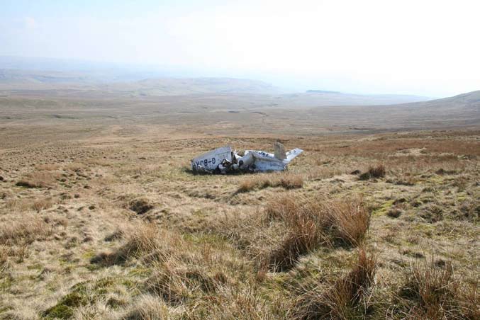
photo: AAIB
Revision history:
| Date/time | Contributor | Updates |
|---|---|---|
| 22-Mar-2011 03:05 | gerard57 | Added |
| 22-Mar-2011 16:47 | P the P | Updated [Aircraft type, Registration, Damage] |
| 23-Mar-2011 14:54 | JINX | Updated [Aircraft type, Cn, Operator, Location, Source, Narrative] |
| 21-Apr-2011 08:50 | TB | Updated [Time, Aircraft type, Operator, Location] |
| 28-Sep-2011 08:28 | Uli Elch | Updated [Aircraft type, Departure airport, Source, Narrative] |
| 30-Sep-2011 19:19 | Dr. John Smith | Updated [Location, Nature, Source, Narrative] |
| 14-Oct-2011 11:41 | Anon. | Updated [Source, Narrative] |
| 15-Sep-2012 16:47 | Dr. John Smith | Updated [Source, Embed code, Narrative] |
| 28-Mar-2015 13:39 | Dr. John Smith | Updated [Departure airport, Source, Narrative] |
| 27-Nov-2016 20:11 | Dr. John Smith | Updated [Cn, Source] |
| 27-Nov-2016 20:17 | Dr. John Smith | Updated [Operator, Departure airport, Destination airport, Narrative] |
| 27-Nov-2016 20:20 | Dr. John Smith | Updated [Source] |
Corrections or additions? ... Edit this accident description
The Aviation Safety Network is an exclusive service provided by:
Quick Links:
| ASN Home | Send Correction / Feedback |
| FSF Home | Disclaimer | Copyright |
| Contact Us | Privacy Policy |
| Press / Media |
 ©2024 Flight Safety Foundation