

ASN Wikibase Occurrence # 139914
This information is added by users of ASN. Neither ASN nor the Flight Safety Foundation are responsible for the completeness or correctness of this information.
If you feel this information is incomplete or incorrect, you can submit corrected information.
| Date: | Wednesday 16 November 2011 |
| Time: | 08:53 LT |
| Type: |  Cessna 172M Skyhawk |
| Owner/operator: | Nusa Flying International |
| Registration: | PK-NIP |
| MSN: | 172-65519 |
| Fatalities: | Fatalities: 3 / Occupants: 3 |
| Aircraft damage: | Destroyed |
| Category: | Accident |
| Location: | Mount Ciremai at Argapura village, Sumedang, Jawa Barat -
 Indonesia Indonesia
|
| Phase: | En route |
| Nature: | Training |
| Departure airport: | Jakarta-Halim Perdana Kusuma Airport (HLP/WIHH) |
| Cirebon-Penggung Airport (CBN/WICD) | |
| Investigating agency: | NTSC |
| Confidence Rating: |
On 16 November 2011 Cessna 172 registration PK-NIP operated by Nusa Flying International (NFI) conducted a training flight for cross country three leg exercise from Halim – Cirebon – Budiarto. The flight was planned to be conducted under (Visual Flight Rules (VFR).
At 00:40 UTC the aircraft departed runway 24 Halim Perdanakusuma Airport. On board in this flight were one Flight Instructor and two student pilots.
At 01:19 UTC the pilot reported to Cakra Tower of Cakrabhuana Airport, Cirebon that the aircraft was over VIRAN heading to "CA" and estimated over "CA" at 01:53 UTC.
Two minutes later the pilot requested to climb to 7500 feet due to bad weather which was approved by Jakarta Info officer.
At 01:40 UTC Jakarta Info operator noticed that PK-NIP had dissappeared from radar screen.
After five days, on 28 November 2011, the aircraft position was identified by local villagers and reported to local police station. The aircraft was found at Ceremai Mountain, Majalengka - West Java on coordinate 06° 53' 30" S, 108° 23' 15" E at elevation approximately 2400 meter, or approximately on bearing 228° and 12 nautical miles from Cakrabhuana Airport.
All occupants were fatally injured and the aircraft suffered severe damage.
Factors:
The flight was in IFR however a witness saw the aircraft flew into the cloud toward ceremai mountain, it was possibly, the pilots had lost of visual references to the ground prior to impact.
This accident classified as Controlled Flight Into terrain (CFIT).
Accident investigation:
 |
|
Sources:
http://www.dephub.go.id/knkt/ntsc_aviation/baru/Final%20Report%20PK-NIP.pdf
http://www.mysinchew.com/node/66543
http://www.pikiran-rakyat.com/node/165940
https://indeks.kompas.com/topik-pilihan/list/1480/pesawat.cessna.172.hilang
http://teknologi.kompasiana.com/terapan/2011/11/18/pk-nip-cessna-172-hilang-di-sekitar-jawa-barat-utara/
http://www.shanghaidaily.org/article/article_xinhua.asp?id=35049
Images:
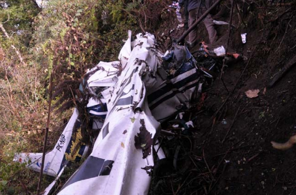
Photo: NTSC
Revision history:
| Date/time | Contributor | Updates |
|---|---|---|
| 16-Nov-2011 05:44 | Alpine Flight | Added |
| 18-Nov-2011 13:30 | Alpine Flight | Updated [Registration, Source, Narrative] |
| 21-Nov-2011 22:01 | romeo_mike | Updated [Departure airport, Destination airport] |
| 27-Nov-2011 05:01 | Alpine Flight | Updated [Aircraft type, Other fatalities, Narrative] |
| 29-Nov-2011 00:44 | gerard57 | Updated [Location, Source, Damage, Narrative] |
| 22-Jul-2013 19:26 | harro | Updated [Aircraft type, Cn, Source, Narrative] |
Corrections or additions? ... Edit this accident description
The Aviation Safety Network is an exclusive service provided by:
Quick Links:
| ASN Home | Send Correction / Feedback |
| FSF Home | Disclaimer | Copyright |
| Contact Us | Privacy Policy |
| Press / Media |
 ©2024 Flight Safety Foundation