

ASN Wikibase Occurrence # 182445
| Date: | Thursday 17 December 2015 |
| Time: | 19:44 |
| Type: |  Van's RV-4 |
| Owner/operator: | Private |
| Registration: | N77BP |
| MSN: | 3281 |
| Year of manufacture: | 1995 |
| Total airframe hrs: | 1012 hours |
| Engine model: | Lycoming O-320-D1B |
| Fatalities: | Fatalities: 2 / Occupants: 2 |
| Aircraft damage: | Destroyed |
| Category: | Accident |
| Location: | Madison County, SW of Madison, FL -
 United States of America United States of America
|
| Phase: | En route |
| Nature: | Private |
| Departure airport: | Apopka, FL (X04) |
| Tallahassee, FL (TLH) | |
| Investigating agency: | NTSB |
| Confidence Rating: |
The airline transport pilot, who was a US Navy flight instructor and newly certificated civilian flight instructor, was flying his cousin to his home base where he planned to provide her with initial flight training. He received a weather briefing earlier in the day, and the briefer indicated that visual flight rules (VFR) flight was not recommended due to instrument meteorological conditions (IMC) at the surface. Despite the briefer's statement, the pilot indicated he planned on remaining VFR throughout the flight.
Before taking off for the accident flight, during ground operations, the pilot discussed the weather with a former flight service station pilot weather briefer, who told the pilot that the weather was "really bad" in the direction of the pilot's destination, and the pilot agreed, yet he chose to depart anyway. He reported that the pilot appeared to be "in a hurry." No evidence was found indicating that the pilot received any additional weather briefing information before taking off for the accident flight.
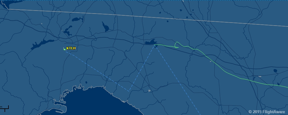
The flight departed to the northwest toward an approaching cold front. The conditions associated with the front included low clouds and mist. As the pilot proceeded toward his destination, the flight encountered the front, and the pilot declared an emergency with air traffic control (ATC), stating that he was in instrument flight rules (IFR) conditions and that his airplane was "not capable of IFR." Radar data of the final segment of the flight showed the airplane in a left, 180-degree turn for 43 seconds, immediately followed by a right, 90-degree turn for 37 seconds before radar and radio contact was lost. The last radar return was observed at an altitude of about 1,200 ft mean sea level.
The wreckage was located about 0.2 nautical mile southeast of the last radar return. Forward-to-aft crushing signatures to the wreckage, damage to adjacent trees, and the lack of a linear wreckage debris path were consistent with a near-vertical, nose-low attitude at impact. An examination of the airframe and engine did not reveal any evidence of a preimpact anomaly or malfunction, and the pilot did not report any mechanical issues to ATC. According to the airplane builder and Federal Aviation Administration records, the airplane was not approved for flight in IMC.
The low visibility conditions that existed during the flight, which was conducted at night in instrument conditions, were conducive to the development of spatial disorientation. Further, the pilot's actions and responses and the airplane's turning ground track and near-vertical descent were consistent with the pilot losing airplane control due to spatial disorientation. The pilot should not have initiated the flight into a known approaching cold front in an airplane not equipped for IMC flight, and this decision directly led to the accident.
Probable Cause: The pilot's decision to initiate the flight into known adverse weather conditions, in an airplane that was not approved for instrument flight, which resulted in an encounter with instrument meteorological conditions and his subsequent spatial disorientation and loss of airplane control.
Accident investigation:
 |
|
Sources:
NTSB
https://flightaware.com/live/flight/N77BP/history/20151217/2309Z/KOCF/KTLH
FAA register: http://registry.faa.gov/aircraftinquiry/NNum_Results.aspx?NNumbertxt=77BP
Location
Images:
Revision history:
| Date/time | Contributor | Updates |
|---|---|---|
| 18-Dec-2015 09:27 | gerard57 | Added |
| 18-Dec-2015 16:28 | Geno | Updated [Time, Registration, Cn, Location, Departure airport, Destination airport, Source, Narrative] |
| 19-Dec-2015 03:56 | Geno | Updated [Total fatalities, Total occupants, Other fatalities, Location, Source, Damage, Narrative] |
| 19-Dec-2015 14:27 | harro | Updated [Source, Embed code] |
| 25-Dec-2015 21:30 | Anon. | Updated [Damage] |
| 21-Dec-2016 19:30 | ASN Update Bot | Updated [Time, Damage, Category, Investigating agency] |
| 14-Mar-2017 07:24 | PiperOnslaught | Updated [Departure airport, Source, Narrative] |
| 19-Aug-2017 13:54 | ASN Update Bot | Updated [Time, Aircraft type, Other fatalities, Destination airport, Source, Embed code, Damage, Narrative] |
The Aviation Safety Network is an exclusive service provided by:
Quick Links:
| ASN Home | Send Correction / Feedback |
| FSF Home | Disclaimer | Copyright |
| Contact Us | Privacy Policy |
| Press / Media |
 ©2024 Flight Safety Foundation