

ASN Wikibase Occurrence # 185878
This information is added by users of ASN. Neither ASN nor the Flight Safety Foundation are responsible for the completeness or correctness of this information.
If you feel this information is incomplete or incorrect, you can submit corrected information.
| Date: | Saturday 26 March 2016 |
| Time: | 00:18 |
| Type: |  Eurocopter AS 350B2 AStar |
| Owner/operator: | Metro Aviation Inc. |
| Registration: | N911GF |
| MSN: | 3119 |
| Year of manufacture: | 1998 |
| Total airframe hrs: | 8923 hours |
| Engine model: | Turbomeca Arriel/1D1 |
| Fatalities: | Fatalities: 4 / Occupants: 4 |
| Aircraft damage: | Substantial |
| Category: | Accident |
| Location: | Coffee County, NNE of Goodman, AL -
 United States of America United States of America
|
| Phase: | Take off |
| Nature: | Ambulance |
| Departure airport: | Goodman, AL (None) |
| Montgomery, AL (AL11) | |
| Investigating agency: | NTSB |
| Confidence Rating: |
After picking up a patient at a motor vehicle accident (MVA) site, the airline transport pilot of the helicopter air ambulance flight, which was operating under visual flight rules (VFR), departed in dark night instrument meteorological conditions (IMC) to transport the patient to a hospital; a flight nurse and paramedic were also on board. Witness statements, video, and photographs indicated that reduced visibility in fog and mist as well as very-light-to-light precipitation existed at the MVA site, and the nearest weather station, 4 miles away, was reporting a 300-ft ceiling and 3 miles visibility. Radar data indicated that, after takeoff, the helicopter entered a left turn and climbed to 1,000 ft above mean sea level (msl). The rate of turn then began to increase, and, after reaching a peak altitude of 1,100 ft msl, the helicopter began a rapid descent that continued to ground impact. According to the radar data, the flight lasted about 1 minute. A search was initiated when the pilot did not check in with the communications center as required, and the wreckage was located the next morning about 1/2 mile from the departure location. Examination of the accident site and wreckage revealed that the helicopter struck trees and terrain and was highly fragmented. Examination of the wreckage did not reveal evidence of any preimpact malfunctions or failures that would have precluded normal operation of the helicopter.
Although the helicopter was not certificated for flight in IMC, it had sufficient instrumentation to operate in the event of an inadvertent encounter with IMC and was equipped with a helicopter terrain avoidance warning system, a night vision imaging system which included night vision goggles (NVGs), and an autopilot. The pilot had about 265 hours experience operating in IMC and had been trained in inadvertent IMC loss of control recovery, but he was not instrument current. Further, he had not been trained or qualified by the operator to fly in IMC. He was likely using NVGs during the flight as one of the first responders who helped load the patient into the helicopter saw the pilot wearing them. Based on the weather conditions, the flight path of the helicopter, and the lack of preimpact failures or anomalies, it is likely that the pilot experienced spatial disorientation after entering IMC and subsequently lost control of the helicopter.
Probable Cause: The pilot's decision to perform visual flight rules flight into night instrument meteorological conditions, which resulted in loss of control due to spatial disorientation. Contributing to the accident was the pilot's self-induced pressure to complete the mission despite the weather conditions and the operator's inadequate oversight of the flight by its operational control center.
Accident investigation:
 |
|
Sources:
NTSB
FAA register: http://registry.faa.gov/aircraftinquiry/NNum_Results.aspx?nNumberTxt=911GF
Location
Images:
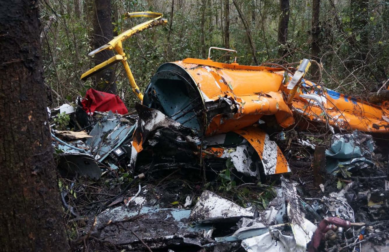
Photo: NTSB
Media:
NTSB investigating today\'s crash of a Eurocopter AS350 in Goodman, AL.
— NTSB (@NTSB) 26 mars 2016
Revision history:
| Date/time | Contributor | Updates |
|---|---|---|
| 26-Mar-2016 15:53 | gerard57 | Added |
| 26-Mar-2016 17:44 | Iceman 29 | Updated [Time, Aircraft type, Destination airport, Source, Narrative] |
| 26-Mar-2016 19:14 | harro | Updated [Aircraft type] |
| 26-Mar-2016 19:20 | harro | Updated [Operator, Location, Destination airport] |
| 26-Mar-2016 19:57 | Iceman 29 | Updated [Embed code] |
| 26-Mar-2016 20:29 | Geno | Updated [Location, Departure airport, Source, Embed code] |
| 27-Mar-2016 07:11 | Chieftain | Updated [Registration, Source] |
| 27-Mar-2016 07:13 | harro | Updated [Registration, Narrative] |
| 27-Mar-2016 10:11 | Iceman 29 | Updated [Embed code, Photo, ] |
| 27-Mar-2016 14:27 | CTYONE | Updated [Aircraft type, Cn] |
| 28-Mar-2016 07:49 | Aerossurance | Updated [Time, Aircraft type, Registration, Cn, Narrative] |
| 28-Mar-2016 12:44 | Aerossurance | Updated [Aircraft type, Narrative] |
| 28-Mar-2016 17:35 | Geno | Updated [Registration, Cn, Operator, Phase, Source, Narrative] |
| 28-Mar-2016 22:42 | Aerossurance | Updated [Narrative] |
| 18-Apr-2016 19:55 | Aerossurance | Updated [Operator, Departure airport, Destination airport, Source, Narrative] |
| 10-May-2016 11:18 | Aerossurance | Updated [Aircraft type] |
| 21-Dec-2016 19:30 | ASN Update Bot | Updated [Time, Damage, Category, Investigating agency] |
| 26-May-2018 13:44 | Aerossurance | Updated [Narrative] |
| 26-May-2018 15:18 | Aerossurance | Updated [Source, Damage] |
| 01-Jun-2018 09:55 | ASN Update Bot | Updated [Operator, Departure airport, Destination airport, Source, Embed code, Damage, Narrative] |
| 01-Jun-2018 11:44 | harro | Updated [Source, Embed code, Narrative, Photo, ] |
Corrections or additions? ... Edit this accident description
The Aviation Safety Network is an exclusive service provided by:
Quick Links:
| ASN Home | Send Correction / Feedback |
| FSF Home | Disclaimer | Copyright |
| Contact Us | Privacy Policy |
| Press / Media |
 ©2024 Flight Safety Foundation