

ASN Wikibase Occurrence # 189388
This information is added by users of ASN. Neither ASN nor the Flight Safety Foundation are responsible for the completeness or correctness of this information.
If you feel this information is incomplete or incorrect, you can submit corrected information.
| Date: | Friday 19 August 2016 |
| Time: | 08:07 |
| Type: |  Thrush S-2R-T660 |
| Owner/operator: | Arnt Aerial Application |
| Registration: | N40499 |
| MSN: | T660-113 |
| Year of manufacture: | 2005 |
| Total airframe hrs: | 4042 hours |
| Engine model: | Pratt & Whitney PT6A-65AG |
| Fatalities: | Fatalities: 1 / Occupants: 1 |
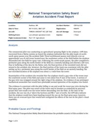
| Aircraft damage: | Destroyed |
| Category: | Accident |
| Location: | W of Ruthton, Pipestone County, MN -
 United States of America United States of America
|
| Phase: | Manoeuvring (airshow, firefighting, ag.ops.) |
| Nature: | Agricultural |
| Departure airport: | Worthington, MN (OTG) |
| Worthington, MN (OTG) | |
| Investigating agency: | NTSB |
| Confidence Rating: |
The commercial pilot was conducting an agricultural spraying flight in the airplane. GPS data recovered from a Satloc system on board the airplane indicated that the pilot made 16 north-south spray passes over the accident field. Three northbound passes went directly over an approximate 200-ft-tall tower located near the southwest corner of the field before the airplane descended into the field for spray runs. Following the north-south passes, the pilot completed a perimeter pass along the north border of the field on a westerly heading and entered a left turn. Due to buffering of the data by the Satloc unit, the final portion of the recorded track did not extend to the accident site; however, the final portion of the track was consistent with the pilot setting up for a perimeter pass along the south border of the field on an easterly heading; the last recorded location of the airplane was about 0.7 mile from the tower.
Examination of the accident site revealed that the airplane struck a guy-wire of the tower near the southwest corner of the field and came to rest about 600 ft east of the tower. A section of the guy-wire was wrapped around the right wing of the airplane. No evidence of any preimpact mechanical anomalies that would have precluded normal operation of the airplane was found.
The evidence is consistent with the pilot failing to see and avoid the tower guy-wire during the final spray pass. The pilot was aware of the tower and its location as evidenced by previous passes that were made over the tower before descending into the field. At the time of the accident, the sun was 16.3° above the horizon and 88.1° east of north; the GPS data indicate that the airplane would have been heading toward the sun on the final spray pass; however, there was an overcast layer that would have mitigated the effects of the sun on the pilot's visual capability.
Probable Cause: The pilot's failure to see and avoid the tower guy-wire during an agricultural spraying operation.
Accident investigation:
 |
|
Sources:
NTSB
FAA register: http://registry.faa.gov/aircraftinquiry/NNum_Results.aspx?NNumbertxt=40499
Location
Images:
Photo: NTSB
Revision history:
| Date/time | Contributor | Updates |
|---|---|---|
| 19-Aug-2016 21:09 | Iceman 29 | Added |
| 19-Aug-2016 23:08 | Geno | Updated [Time, Aircraft type, Registration, Cn, Operator, Location, Phase, Departure airport, Destination airport, Source, Narrative] |
| 22-Aug-2016 18:18 | Geno | Updated [Registration, Source, Narrative] |
| 15-Nov-2018 08:48 | ASN Update Bot | Updated [Time, Operator, Departure airport, Destination airport, Source, Narrative, Accident report, ] |
| 15-Nov-2018 08:58 | harro | Updated [Source, Narrative, Photo] |
Corrections or additions? ... Edit this accident description
The Aviation Safety Network is an exclusive service provided by:
Quick Links:
| ASN Home | Send Correction / Feedback |
| FSF Home | Disclaimer | Copyright |
| Contact Us | Privacy Policy |
| Press / Media |
 ©2024 Flight Safety Foundation