

ASN Wikibase Occurrence # 190178
This information is added by users of ASN. Neither ASN nor the Flight Safety Foundation are responsible for the completeness or correctness of this information.
If you feel this information is incomplete or incorrect, you can submit corrected information.
| Date: | Saturday 17 September 2016 |
| Time: | 02:04 LT |
| Type: |  Agusta A109S Grand |
| Owner/operator: | North Memorial Air Care |
| Registration: | N91NM |
| MSN: | 22014 |
| Year of manufacture: | 2006 |
| Total airframe hrs: | 1659 hours |
| Engine model: | Pratt & Whitney Canada PW207C |
| Fatalities: | Fatalities: 0 / Occupants: 3 |
| Aircraft damage: | Destroyed |
| Category: | Accident |
| Location: | Lake Winona, near Alexandria, MN -
 United States of America United States of America
|
| Phase: | Approach |
| Nature: | Ambulance |
| Departure airport: | Brainerd, MN (BRD) |
| Alexandria, MN (AXN) | |
| Investigating agency: | NTSB |
| Confidence Rating: |
The pilot and two medical crewmembers were conducting a night instrument flight rules cross-country flight to pick up a patient. During the instrument approach to the destination airport, the weather conditions deteriorated. The pilot was using the helicopter's autopilot to fly the GPS approach to the airport, and the pilot and the medical crew reported normal helicopter operations. Upon reaching the GPS approach minimum descent altitude, the pilot was unable to see the airport and executed a go-around. The pilot reported that, after initiating the go-around, he attempted to counteract, with right cyclic input, an uncommanded sharp left 45° bank . Recorded flight data revealed that the helicopter climbed and made a progressive right bank that reached 50°. The helicopter descended as the right bank continued, and the airspeed increased until the helicopter impacted treetops. The helicopter then impacted terrain on it's right side and came to rest near a group of trees.
Postaccident examinations of the helicopter and flight control systems did not reveal any malfunctions or anomalies that would have precluded normal operation. The helicopter was equipped with a GPS roll steering modification that featured a switch that allowed the pilot to manually select the heading reference source. In case of a malfunction or an erroneous setting, the helicopter's automatic flight control system had at least two limiters in place to prevent excessive roll commands. Further testing revealed that the GPS roll steering modification could not compromise the flight director and autopilot functionalities to the point of upsetting the helicopter attitudes or moving beyond the systems limiters.
Recorded helicopter, engine, and flight track data were analyzed and used to conduct flight simulations. The simulations revealed that the helicopter was operated within the prescribed limits; no evidence of an uncommanded 45° left bank was found. The helicopter performed a constant right climbing turn with decreasing airspeed followed by a progressive right bank with the airspeed and descent rate increasing. In order to recover, the simulations required large collective inputs and a steep right bank; such maneuvers are difficult when performed in night conditions with no visual references, although less demanding in day conditions with clear visual references. The data are indicative of a descending accelerated spiral, likely precipitated by the pilot inputting excessive right cyclic control during the missed approach go-around maneuver, which resulted in a loss of control.
Probable Cause: The pilot's excessive cyclic input during a missed approach maneuver in night instrument meteorological conditions, which resulted in a loss of control and spiraling descent into terrain.
Accident investigation:
 |
|
Sources:
NTSB
http://aerossurance.com/helicopters/hems-a109s-night-loci/
https://flightaware.com/live/flight_track_bigmap.rvt?ident=N91NM-1474093159-6-0-18
FAA register: http://registry.faa.gov/aircraftinquiry/NNum_Results.aspx?NNumbertxt=91NM
Location
Images:
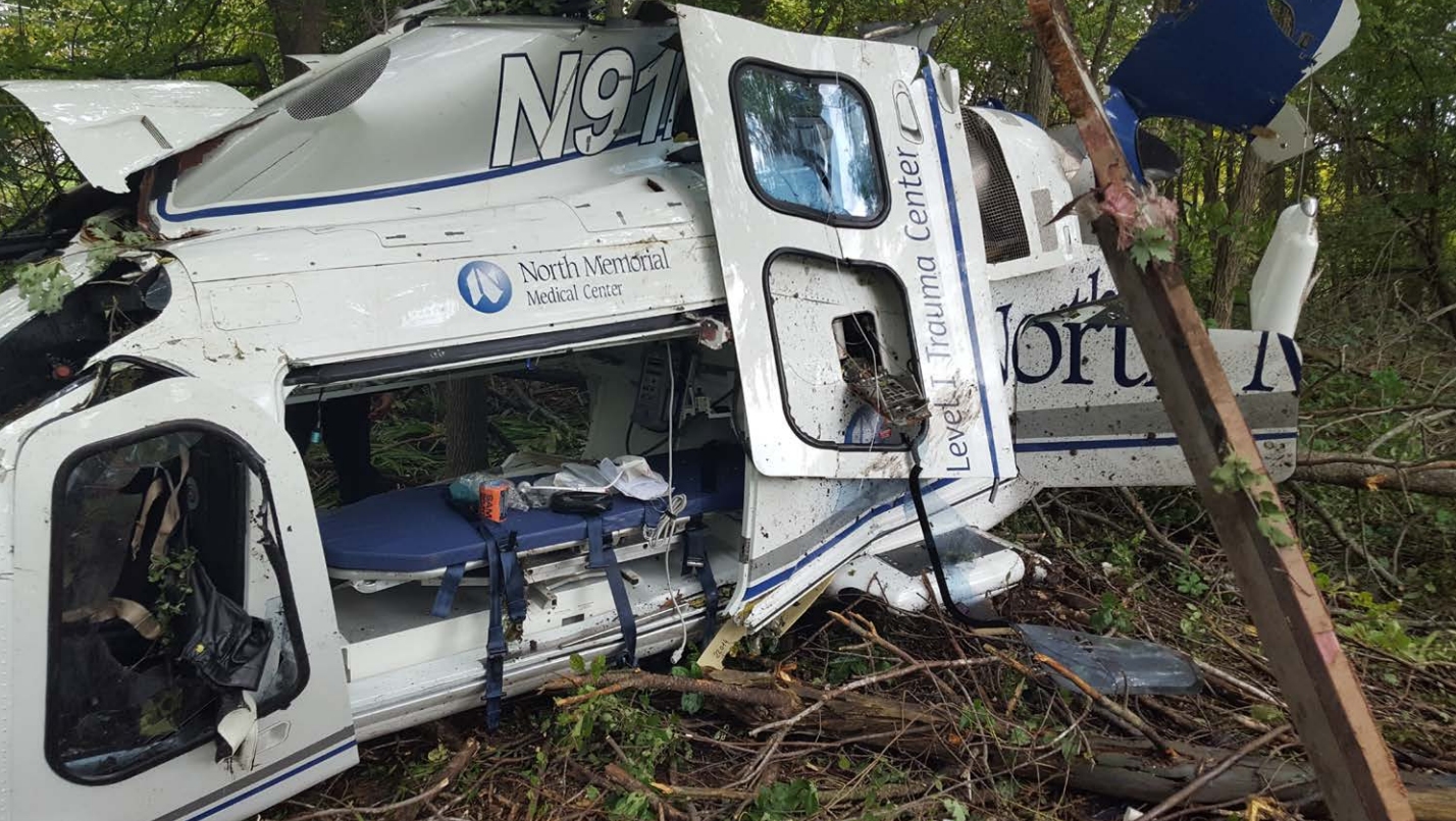
Photo: NTSB

Graphic: NTSB
Media:
#OTD in 2016: The pilot and 2 medical personnel were seriously injured and their #helicopter destroyed in yet another night HEMS #airambulance #accident in the US.https://t.co/whJOgsTaNR #flightsafety #aviationsafety pic.twitter.com/OLVQGIQPiP
— Aerossurance (@Aerossurance) September 17, 2020
Revision history:
| Date/time | Contributor | Updates |
|---|---|---|
| 17-Sep-2016 18:19 | gerard57 | Added |
| 17-Sep-2016 18:21 | harro | Updated [Date, Operator, Location] |
| 17-Sep-2016 18:22 | harro | Updated [Aircraft type] |
| 18-Sep-2016 06:55 | reformFAAnow | Updated [Time, Registration, Source, Narrative] |
| 18-Sep-2016 07:13 | Aerossurance | Updated [Time, Aircraft type, Cn, Source, Narrative] |
| 18-Sep-2016 16:58 | Aerossurance | Updated [Location, Source, Narrative] |
| 19-Sep-2016 20:03 | Aerossurance | Updated [Source] |
| 05-Oct-2016 22:48 | Aerossurance | Updated [Phase, Departure airport, Destination airport, Source, Narrative] |
| 09-Sep-2018 17:26 | ASN Update Bot | Updated [Time, Operator, Departure airport, Destination airport, Source, Narrative, Accident report, ] |
| 09-Sep-2018 17:57 | harro | Updated [Source, Narrative, Photo] |
| 09-Sep-2018 17:57 | harro | Updated [Photo] |
| 29-Sep-2018 09:08 | Aerossurance | Updated [Time, Source] |
| 17-Sep-2020 06:59 | Aerossurance | Updated [Embed code] |
Corrections or additions? ... Edit this accident description
The Aviation Safety Network is an exclusive service provided by:
Quick Links:
| ASN Home | Send Correction / Feedback |
| FSF Home | Disclaimer | Copyright |
| Contact Us | Privacy Policy |
| Press / Media |
 ©2024 Flight Safety Foundation